This item has been sold, but you can get on the Waitlist to be notified if another example becomes available, or purchase a digital scan.
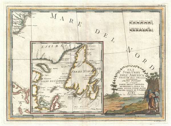
1797 Cassini Map of Newfoundland, Canada and Cape Fear, North Carolina
Newfoundland-cassini-1797$375.00

Title
Gli Stati Uniti dell' America delineati sulle ultime Osservazioni, Sesto Foglio che comprende parte della Carolina ed inoltre l'Isola di Terra Nuova colle altre isole del Golfo di S. Lorenzo.
1797 (dated) 15 x 20 in (38.1 x 50.8 cm) 1 : 3400000
1797 (dated) 15 x 20 in (38.1 x 50.8 cm) 1 : 3400000
Description
An unusually laid out example of Cassini's stunning 1797 map of North and South Carolina, Newfoundland, and part of the Bahamas. The map is dominated by a large inset of Newfoundland also covering parts of Labrador and Cape Breton Island. Beyond the inset, the map itself is set in the Atlantic Ocean near Cape Fear and Charleston, South Carolina, which is evident in the upper left corner. In the bottom left, part of the Bahamas are visible. The coverage of this map is, as we have already stated, unusual, but is derived from Cassini's sourcing of his North American Series from the Zatta-Mitchell map of 1755.
Cartographically Cassini derived this map from the 1778 Zatta 12 sheet revision and expansions of the John Mitchell's seminal 1755 map of the eastern part of North America. Cassini published six maps of United States regions based upon Zatta's work, of which this is map no. 6. This work was published in Cassini's 1797 Nuovo Atlante Geografico Universale. Today all maps from this series are highly sought after for their exceptional beauty and fine engraving.
Cartographically Cassini derived this map from the 1778 Zatta 12 sheet revision and expansions of the John Mitchell's seminal 1755 map of the eastern part of North America. Cassini published six maps of United States regions based upon Zatta's work, of which this is map no. 6. This work was published in Cassini's 1797 Nuovo Atlante Geografico Universale. Today all maps from this series are highly sought after for their exceptional beauty and fine engraving.
Cartographer
Giovanni Maria Cassini (1745 - 1824) was a Rome based Italian mathematician, globe maker, geographer, engraver, and cartographer active in the later part of the 18th and early 19th century. He was a disciple of Giovanni Battista Piranesi. He invented new form of projection used for an atlas of the kingdom of Naples issued by Giovanni Antonio Rizzi Zannoni. Cassini is best known as a globe maker and is considered the last of the great 18th century globe makers. His maps are distinctive for their fine engraving, dark strong impressions, and elaborate distinctive cartouche work. Unlike many map and atlas publishers of the period, Cassini did all of his own engraving work - this impregnating each map with his unmistakable style. Though he produced a significant corpus of well-regarded work, little is known of Cassini's personal life. G. M. Cassini is often mistakenly associated with the well-known French cartographic family of the same name, however, they are not related. More by this mapmaker...
Condition
Very Good. Minor centerfold wear and toning. Wide margins. Blank on verso. Platemark visible.
References
OCLC 456402522. McCorkle, B. B, New England in Early Printed Maps 1513 - 1800, 797.3.