This item has been sold, but you can get on the Waitlist to be notified if another example becomes available, or purchase a digital scan.
1904 Scarborough Map of New Hampshire
NewHampshire-scarborough-1904$275.00


Title
Scarborough's Map of New Hampshire.
1904 (dated) 42.5 x 34 in (107.95 x 86.36 cm) 1 : 285120
1904 (dated) 42.5 x 34 in (107.95 x 86.36 cm) 1 : 285120
Description
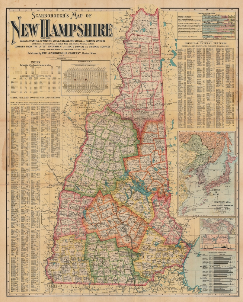
This is a 1904 Scarborough Company map of New Hampshire. Scarborough maps are widely admired for their boldly distinctive typography, and New Hampshire is among the rarest in the series. The map includes insets illustrating current events: the Russo-Japanese War and the construction of the Panama Canal. Although unfolding far from New Hampshire, their inclusion here is no error and underscores the state's global maritime connections out of Portsmouth. Scarborough maps are much admired for their bold distinctive typography.
Two inset maps along the right border highlight the major news events of 1904. The larger illustrates eastern Asia, specifically Japan, Korea, and eastern China and Russia. At the time, the Russo-Japanese War (1904 - 1905) was raging. The second smaller inset map focuses on the Panama Canal. Construction began on the Panama Canal on May 4, 1904 and was a topic of worldwide interest. Here, the maps illustrate how the canal planned to connect the Atlantic and Pacific Oceans, its route across Panama, and the route's profile. A chart in the lower left underscores the projected shorter transit routes between New York, New Orleans, San Francisco, and Liverpool.
A Closer Look
Coverage embraces New Hampshire in detail including road and train connections to adjacent states. Towns, townships, and counties are noted along with lakes, rivers, hills, and other physical features. Several indexes appear to the left and right, listing New Hampshire's cities, towns, counties, and principal natural features. A graph illustrating population and manufacturing statistics occupies the upper right.Two inset maps along the right border highlight the major news events of 1904. The larger illustrates eastern Asia, specifically Japan, Korea, and eastern China and Russia. At the time, the Russo-Japanese War (1904 - 1905) was raging. The second smaller inset map focuses on the Panama Canal. Construction began on the Panama Canal on May 4, 1904 and was a topic of worldwide interest. Here, the maps illustrate how the canal planned to connect the Atlantic and Pacific Oceans, its route across Panama, and the route's profile. A chart in the lower left underscores the projected shorter transit routes between New York, New Orleans, San Francisco, and Liverpool.
Publication History and Census
This map was created and published by the Scarborough Company in 1904. We note three examples cataloged in OCLC: Boston Public Library, the New Hampshire State Library, and Duke University.Cartographer
Scarborough Company (1885 - 1913) was founded by the brothers Walter C. Scarborough (June 4, 1862 - May 9, 1904) and Howard G. Scarborough (December 23, 1867 - June 10, 1905). Walter, the older brother, was born in Providence, Rhode Island, and studied at the Boston University Law School. The Scarborough brothers founded their map publishing concern in 1885. Initially, there were three separate firms: the National Publishing Company (Portland, Maine, 1897), later based in Boston; the Dominion Publishing Company, based in Canada; and the Scarborough Publishing Company, based in London. These three firms each published semi-independently but were merged with a capital of 1,000,000 USD in 1902, subsequently publishing under the Scarborough imprint. Howard took over full management of the Scarborough in 1904 when Walter died. Howard was also in poor health, suffering from tuberculous, and relocated to Europe in 1900, where he lived in a sanatorium. He returned to the United States in 1902, settling first in Asheville, North Carolina, then at a sanatorium community in Oracle, Arizona. Until his death, he managed the Scarborough Company remotely. From about 1904, there was another branch of the firm located at 227 East Ohio Street in Indianapolis, Indiana. After Howard's 1905 death, the management of the firm, as well as its principal manufacturing and distribution points, was relocated to Indianapolis. In 1913, it became the Scarborough Motor Guide Company (c. 1913 - c. 1933). More by this mapmaker...
Condition
Fair. Wear along original fold lines. Verso repairs to fold separations and at fold intersections. Soiling.
References
OCLC 57272721.