This item has been sold, but you can get on the Waitlist to be notified if another example becomes available, or purchase a digital scan.
1926 Shurtleff Pictorial Map of New Hampshire
NewHampshire-shurtleff-1926$550.00

Title
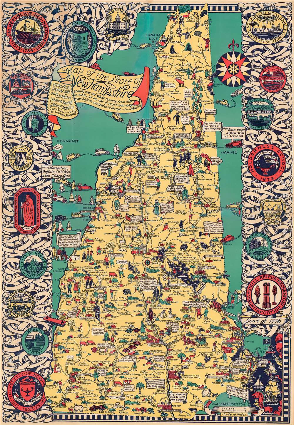
Map of the State of New Hampshire.
1926 (dated) 33.5 x 23.25 in (85.09 x 59.055 cm) 1 : 345000
1926 (dated) 33.5 x 23.25 in (85.09 x 59.055 cm) 1 : 345000
Description
This is a 1926 Elizabeth Shurtleff and Helen F. McMillin pictorial map of New Hampshire. Shurtleff and McMillin were among the most prominent of the pioneering female artists who influenced the Golden Age of American Pictorial Cartography - from the 1920s - 1940s. Shurtleff was a New Hampshire native, and this map represents some of her earliest formative work - and as such offers both scarcity and significance.
A Closer Look
The authors effortlessly blend geographic information with comic vignettes: hunter telling a moose to 'stand still, now!', 'portraits' of Washington, Jefferson, Adams, Monroe, and Madison in the place of mountains named after them, and road signs that read 'From Bethel, Bangor, Labrador, and Iceland' and 'From Newburyport, Boston, Florida, and the Cape of Good Hope'. Phillips Exeter Academy is illustrated and labeled in the lower right, not far from New Hampshire University. Dartmouth College is also prominent, with a bright green banner proclaiming the college's name and students carrying suitcases emblazoned with large capital 'D's. Both Lake Winnipesaukee and Lake Asquam are located, as they appear as a dark black against the yellow used to shade New Hampshire. Seals of various organizations, cities, and towns, including Phillips Exeter Academy, the Holderness School, Dartmouth College, Manchester, and Nashua occupy the left and right borders.Publication History and Census
This map was designed, drawn, and published by Elizabeth Shurtleff and Helen F. McMillin in 1926. We note a handful of cataloged examples, which are part of the collection at the Norman B. Leventhal Map Center at the Boston Public Library, the American Geographical Society Library at the University of Wisconsin Milwaukee, the New Hampshire Historical Society, and the David Rumsey Map Center at Stanford University.CartographerS
Elizabeth Shurtleff (September 3, 1890 - December 7, 1968), or Elizabeth Cate, was an American painter and artist active in the middle part of the 20th century. She was born in Concord, New Hampshire and attended the Boston Museum School of Fine Arts. Shurtleff is known for a small but significant corpus of pictorial maps issued alone and in collaboration with others between 1926 and 1930. She frequently collaborated with Wellesley graduates and pictorial mapmakers Helen F. McMillin, Elizabeth L. McMillin, and Alva Bennett Scott. These women were at the forefront of a new generation of female mapmakers emerging in the mid-20th century. Together with Helen F. McMillin, Shurtleff headed the Boston based Graphic History Association Publishers of Historical Maps. Elizabeth was married to Carroll L. Cate of Montreal. She died in Montreal in 1968. More by this mapmaker...
Helen Frances McMillin (June 9, 1896 - June 6, 1987) was and American publisher, writer, editor, and illustrator active in the middle part of the 20th century. McMillin was born to a prominent family of North Adams, Massachusetts and attended Wellesley College, where she was editor of the Wellesley Legenda and Wellesley College News. =After graduating in 1917, she moved to Boston, where she worked as publisher of the Granite Monthly. She remained in until at least 1926, but in 1930 she was living in New York City where she worked at the Museum of Modern Art. We have had a difficult time assessing out her marriage situation based upon announcements published in the North Adams Transcript. In 1921 there was an announcement of her engagement to Royal Stuart Steiner of Wisconsin, an economics professor. Another announcement appeared in 1930, to Richard G. Francois of New York. A third appears to suggest she married Royal Stewart Van de Woestyne (1892 - 1967), a Knox College economic professor, in 1933. Based upon ancestry research, it appears that Steiner and Van de Woestyne are one in the same, and so a name change may have occurred, for unclear reasons. She is the aunt of another important female pictorial map mapmaker and artist, Elisabeth L. McMillin (1909 - 19??). Together with Helen F. McMillin, Shurtleff headed the Boston based Graphic History Association Publishers of Historical Maps, which published several important pictorial maps between 1926 and 1936. Helen died in Hamilton, Ohio. Learn More...
Condition
Good. Mounted on heavy linen.
References
Boston Public Library Norman B. Leventhal Map Center G3741.A5 1926 .S58. New Hampshire Historical Society 912.778 S562 c. 1. Stanford University David Rumsey Map Center G3741.A5 1926 .S5. OCLC 1037496198.