1856 Smith Wall Map of New Haven County, Connecticut
NewHaven-smith-1856$2,250.00


Title
Map of New Haven County Connecticut.
1856 (dated) 58 x 55 in (147.32 x 139.7 cm) 1 : 50000
1856 (dated) 58 x 55 in (147.32 x 139.7 cm) 1 : 50000
Description
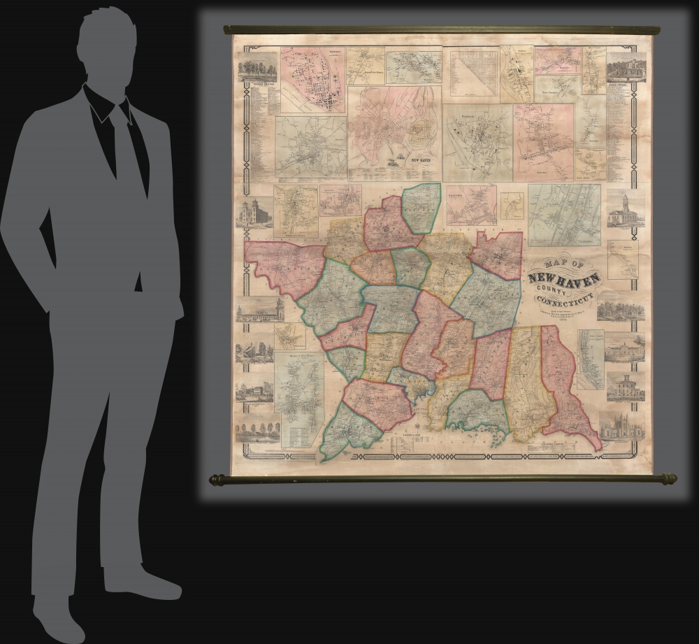
This is an impressive large-scale 1856 H. and C. T. Smith wall map of New Haven County, Connecticut. The map captures New Haven at the height of the industrial revolution, when expanding industry and railroads transformed it into a center of commerce and manufacturing.
A Closer Look
The map embraces New Haven County and is subdivided into townships. Individual property owners are noted both on the primary map and in some of the insets. Business directories for New Haven and Waterbury are in the upper left and right corners, respectively. Inset maps include: New Haven, Birmingham, Milford, North Haven bridge, Westville, Waate4rbury, Ansonia, Madison, Mount Carmel, Cheshire, Guilford, East Haven, Bedford, Mixville, Wallingford, Oxford, Humphreysville, Waterville, Meriden, Derby Narros, and Naugatuck. The border decoration features twelve vignette images capturing local buildings of interest - including two images of Yale.Historical Context
Like much of the country, in the 1850s, New Haven was experiencing a period of growth and transformation marked by the wide-scale industrialization. The city of New Haven transformed into a center for manufacturing and innovation. Prominent industries included the production of carriages, firearms, and hardware. The county's economy was also bolstered by its bustling harbor and the development of railroads, enhancing trade and transportation. Additionally, the intellectual and cultural landscape of New Haven was defined by Yale University, contributing to the county's reputation as a center of education and progressive thought.Publication History and Census
This map was compiled and published in 1856. The copyright at the bottom left was filed by the well-known map publisher Robert Pearsall Smith, however, the publishers are identified as H. and C. T. Smith. Despite publishing at least 5 significant wall maps, this firm has proven elusive. We see four examples in OCLC: Yale University, the Library of Congress, Connecticut Museum of Culture and History, and the University of Wisconsin-Milwaukee.CartographerS
Robert Pearsall Smith (February 1, 1827 - April 17, 1898) was an American map maker active in Philadelphia from the middle to late 19th century. Smith was born to a Quaker family in Philadelphia, all librarians and publishers. Robert Pearsall originally ran a law bookstore at 19 James Street, Philadelphia. It was not until 1846 that Smith began producing maps in collaboration with this father, John Jay Smith, and brother, Lloyd P. Smith. One year earlier, in 1845, John Jay, then librarian at the Library Company of Philadelphia and Loganian Library, acquired the American rights to the anastatic process of transfer lithography. In February of 1846 he and his two sons founded the Anastatic Office, a printing concern based on the anastatic process located at 317 Market Street, Philadelphia. The Anastatic Office produced numerous copies and reissues of historic documents and maps from the Library Company's collection before being dissolved in 1847. In the same year Robert Pearsall opened a printing establishment under his own name at 144 Chestnut Street. In 1858, he joined forced with the Swiss-American engraver Frederick Bourquin (1808 - 1897) under the imprint 'F. Bourquin and Company' (602 Chestnut Street). Smith retired suddenly and inexplicably from the printing business around 1865. Smith was also deeply religious, a lay leader in the Holiness Movement in the United States and the Higher Life Movement in Great Britain. Smith and his wife, Hannah Tatum Whitall, first crossed the Atlantic to preach in England, Germany and Switzerland in 1873. They returned in 1875, preaching in Brighton, where Smith supposedly had an affair with an American writer. In, 1888, his entire family moved to England. More by this mapmaker...
H. and C. T. Smith (fl. c. 1855 - 1862) was a Philadelphia based map publisher active in the mid-19th century. The firm is commonly associated with Robert Pearsall Smith (1827 - 1898), who filed for the copyright on many of their maps. These individuals may or may not have been related. R. P. Smith did have a brother, Horace Smith, but of C. T., we can find nothing, nor can we conform Horace's involvement in H. and C. T. Publications include county wall maps of Connecticut, New York, New Jersey, and Massachusetts. Learn More...
Condition
Very good. Professional restoration and stabilization. Measurements do not include rollers.
References
OCLC 33500621, 857109180. Library of Congress, G3783.N3 1856 .H2. Stephenson, Land Ownership Maps, #65. Thompson, E., Maps of Connecticut for the Years of the Industrial Revolution, #154. Rumsey 1583.