1834 Burr Map of Australia and New Zealand
NewHolland-burr-1835$350.00

Title
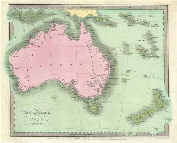
New Holland, and New Zealand.
1834 (dated) 11.5 x 14 in (29.21 x 35.56 cm) 1 : 20000000
1834 (dated) 11.5 x 14 in (29.21 x 35.56 cm) 1 : 20000000
Description
This is an attractive 1834 first edition map of Australia and New Zealand by David H. Burr. It covers all of Australia, including Tasmania, and New Zealand along with a few Pacific Islands. Gone are many of the errors of the previous century with the coastlines accurately rendered. Inland though, much remained confused. Vast stretches of unmapped territory and speculative cartography fill central both Australia and New Zealand. In 1840, after the signing of the Treaty of Waitangi, the British annexed New Zealand as part of the Australian colony of New South Wales. However, it separated from New South Wales to become a colony in its own right in 1841.
During this time in history, Burma was under British rule, while much of modern day Indonesia including Sumatra and parts of Borneo were part of the Dutch commercial colony of the Dutch East Indies. The French dominated Indochina, including Cambodia and Vietnam and most of the modern day Philippines were a Spanish territory called Spanish East Indies. Only Thailand (Siam) and China retained national sovereignty.
According to Ristow, although Burr is credited on the title page, he left this atlas incomplete. He was appointed as topographer to the U.S. Post Office, and of the sixty-three maps finally included in this atlas, only completed eight. The rest of the maps were then completed by Illman and Pilbrow in Burr's style. This map was ‘Entered according to act of Congress in the year 1835 by Illman and Pilbrow in the Clerk’s office of the District Court for the Southern District of New York’, but was not published until the atlas was released in 1835. Published by D. S. Stone in Burr’s New Universal Atlas.
CartographerS
David Hugh Burr (August 18, 1803 - December 25, 1875) of one of the first and most important truly American cartographers and map publishers. Burr was born in Bridgeport Connecticut in August of 1803. In 1822 Burr moved to Kingsboro, New York to study law. A year and a half later he was admitted to the New York Bar association. Burr must have questioned his choice of careers because shortly after being admitted to the Bar, he joined the New York State Militia. Though largely untrained in the art of surveying, Burr was assigned to work under Surveyor General of New York, Simeon De Witt, to survey several New York Roadways. Seeing a window of opportunity, Burr was able to negotiate with the governor of New York at the time, De Witt Clinton, to obtain copies of other New York survey work in order to compile a map and Atlas of the state of New York. Recognizing the need for quality survey work of its territory, the government of New York heartily endorsed and financed Burr's efforts. The resulting 1829 Atlas of the State of New York was the second atlas of an individual U.S. state and one of the most important state atlases ever produced. Burr went on to issue other maps both of New York and of the United States in general. In cooperation with publishing firm of Illman & Pillbrow, he produced an important New Universal Atlas and, with J.H. Colton, several very important maps of New York City. In recognition of this work, Burr was appointed both "Topographer to the Post office" and "Geographer to the House of Representatives of the United States". Later, in 1855, Burr was assigned to the newly created position of Surveyor General to the State of Utah. Burr retired from the position and from cartographic work in general in 1857 when light of some of his financial misdeeds and frauds came to light. He was accused of submitting false expense reports and underpaying employees, among other indiscretions. More by this mapmaker...
Thomas Illman (fl. c. 1824 – 1858) was an English engraver active in New York City during the early 19th century. Illman was born in England and attended Trinity College in Oxford where he attained a degree in theology. Despite initial religious fervor, he soon became an atheist. Professionally he turned to engraving to support his artistic tendencies. In London he mastered the engraver's art. His first paying work as an artist was illustrating for Thomas Carlyle's Confessions of an English Opium Eater. He relocated to New York City in 1828, almost immediately partnering with Edward Pilbrow to found the firm Illman and Pilbrow. Illman and Pillbrow were almost immediately hired by David H. Burr to engrave maps for his Universal Atlas, which he began working on in that year. When Burr took a position as topographer and cartographer for the United States Post Office, he ceded all remaining work on the Atlas to Illman and Pilbrow. In addition to his atlas work, Illman privately pursued his own art as well as engraved portraits and landscapes. He was admired as a skilled line, stipple, and mezzotint engraver. At some point he may have relocated to Philadelphia. His sons, H. Illman and G. Illman followed in his footsteps founding Illman Sons in 1845 Learn More...
Source
Burr, David H., A New Universal Atlas; Comprising Separate Maps of All the Principal Empires, Kingdoms & States Throughout the World: and forming a distinct Atlas of the United States, (New York: D. S. Stone) 1835 (First Edition).
Burr's New Universal Atlas was first published in 1835. It is one of the first great American commercial atlases and one of the most important to appear before the Civil War. Burr was most likely initially inspired to publish a 'universal atlas' in pursuit a more general audience by the success of his 1829 Atlas of New York State. He began work on the Universal Atlas sometime around 1830. By 1832 he had copyrighted eight new maps for the work. Around this time he accepted a position as topographer and cartographer for the United States Postal Department and was thus unable to finish the atlas personally. Instead, while retaining editing rights and overall ownership, Burr passed much of the production work to his engravers Thomas Illman and Edward Pillbrow. The first edition of the atlas was completed in 1835 and published by D. S. Stone of New York. A second edition, published by William Hall, appeared in the following year, 1836. Both editions featured 63 maps, the first part of the book being dedicated to world maps and the second part to the Americas, particularly the United States. Some of the 1836 editions feature outline rather than the distinctive full color common in the first edition. The plates for the atlas were later sold to Jeremiah Greenleaf who expanded the atlas to 65 maps and issued editions in 1840, 1842, and 1848.
Condition
Very good. Minor foxing. Original platemark visible.
References
Rumsey 4628.026. Philips (Atlases) 771.