1846 Bradford Map of New Jersey
NewJersey-bradford-1846$250.00

Title
New Jersey.
1846 (dated) 15 x 12 in (38.1 x 30.48 cm) 1 : 760000
1846 (dated) 15 x 12 in (38.1 x 30.48 cm) 1 : 760000
Description
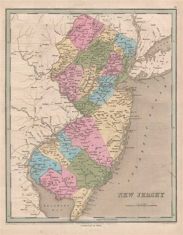
This is an 1846 Thomas G. Bradford map of New Jersey. The map depicts the region from Pennsylvania to Long Island and Connecticut and from Pennsylvania and New York to Delaware, Delaware Bay, and the Atlantic Ocean. As is the case among many maps from Bradford's A Universal Illustrated Atlas, the extensive railroad network in New Jersey is featured.
Railroads in New Jersey
Several different railroads are illustrated, including the Camden and Amboy, the New Jersey Rail Road, and the Central Railroad of New Jersey. The Camden and Amboy was chartered on February 4, 1830, making it one of the ten earliest permanent North American railroads. The Camden and Amboy ran south from New York Harbor at South Amboy to Camden, where it provided a connection to a ferry on the Delaware River to Philadelphia. The New Jersey Rail Road and Transportation Company (NJRR) was chartered on March 7, 1832 and planned as a parallel route to the Camden and Amboy. Connecting Jersey City to Trenton, the NJRR provided the same service as the Camden and Amboy, except the journey by ferry to Jersey City from New York City was shorter than the crossing the South Amboy. The NJRR, which eventually ran through New Brunswick, slowly began consolidating ownership of the region's bridges and turnpikes, and by 1846 held a fairly strong monopoly on bridges over the Passaic, Hackensack, and Raritan Rivers. The Central Railroad of New Jersey, was originally chartered as the Elizabethtown and Somerville Railroad on February 9, 1831. The completion of new lines connected it with the New Jersey Rail Road and the Somerville and Easton Railroad. The Elizabethtown and Somerville bought the Somerville and Easton in 1849 to become the Central Railroad of New Jersey. Today, all of these lines are part of the NJ TRANSIT network, the PATH network, Amtrak, or Conrail.
Highly detailed, each county is illustrated, labeled, and shaded a different color to allow for easy differentiation. Numerous cities and towns are labeled, including Jersey City, Hoboken, New Brunswick, Princeton, Elizabethtown, Trenton, and Camden. Outside New Jersey, the cities of New York, Brooklyn, Williamsburg, and Flatbush are labeled in New York, Philadelphia is labeled in Pennsylvania, and Dover is labeled in Delaware. Myriad rivers and lakes are depicted and labeled throughout the state, including the Delaware River, along with Delaware Bay, Rariton Bay, and New York Bay. The coast of New Jersey is depicted in detail and Cape May is labeled.
This map was engraved by George Boynton and published in the 1846 edition of Bradford and Goodrich's A Universal Illustrated Atlas.
CartographerS
Thomas Gamaliel Bradford (1802 - 1887) was born in Boston, Massachusetts, where he worked as an assistant editor for the Encyclopedia Americana. Bradford's first major cartographic work was his revision and subsequent republishing of an important French geography by Adrian Balbi, Abrege de Geographie published in America as Atlas Designed to Illustrate the Abridgment of Universal Geography, Modern and Ancient. Afterwards Bradford revised and expanded this work into his own important contributions to American cartography, the 1838 An Illustrated Atlas Geographical, Statistical and Historical of the United States and Adjacent Countries. Bradford's cartographic work is significant as among the first to record Texas as an independent nation. In his long career as a map publisher Bradford worked with William Davis Ticknor of Boston, Freeman Hunt of New York, Charles De Silver of Philadelphia, John Hinton, George Washington Boynton, and others. We have been able to discover little of Bradford's personal life. More by this mapmaker...
George Washington Boynton (fl. c. 1830 - 1850) was a Boston based cartographer and map engraver active in the first half of the 19th century. Boynton engraved and compiled maps for numerous publishers including Thomas Bradford, Nathaniel Dearborn, Daniel Adams, and S. G. Goodrich. His most significant work is most likely his engraving of various maps for Bradford's Illustrated Atlas, Geographical, Statistical, and Historical, of the United States and the Adjacent Countries and Universal Illustrated Atlas. He also engraved for the Boston Almanac. In 1835, Boynton is listed as an employee of the Boston Bewick Company, an engraving, stereotype, and printing concern based at no. 47 Court Street, Boston. Little else is known of his life. Learn More...
Source
Bradford, T. G. and Goodrich, S. G., A Universal Illustrated Atlas, exhibiting a Geographical, Statistical, and Historical view of the World, (Boston: Charles D. Strong) 1846.
The Universal Illustrated Atlas is one of the great American atlases of the first half of the 19th century. The atlas was first published in 1838 under the imprint of Charles D. Strong. It replaced and superseded Bradford's earlier smaller format Illustrated Atlas, Geographical, Statistical, and Historical, of the United States and the Adjacent Countries. Numerous reissues of the Universal Illustrated Atlas followed until about 1848. Although there are minor variations between the editions, most contain about 50 maps, the majority of which focus on the United States. Bradford's atlases are significant for recording North America during the Republic of Texas Era. In later editions, particularly the 1846 edition, Bradford illustrates the boom in railroad construction, possibly with the idea that his maps would aid travelers in planning journeys by rail. It was compiled by Thomas Gamaliel Bradford and Samuel Griswold Goodrich with most of the plates engraved by George Washington Boynton (fl. c. 1830 - 1850). Other contributors include Thomas Gordon (1778 - 1848), Fielding Lucas Jr. (1781 - 1854), Samuel Edward Stiles (1844 - 1901), Sherman and Smith (fl. c. 1829 - 1855), and Horace Thayer (1811 - c. 1874).
Condition
Very good. Even overall toning. Light soiling. Blank on verso.
References
Rumsey 0089.015 (1838 edition).