1849 Greenleaf Map of New Jersey
NewJersey-greenleaf-1849$300.00

Title
New Jersey.
1849 (undated) 12.75 x 10.5 in (32.385 x 26.67 cm) 1 : 860000
1849 (undated) 12.75 x 10.5 in (32.385 x 26.67 cm) 1 : 860000
Description
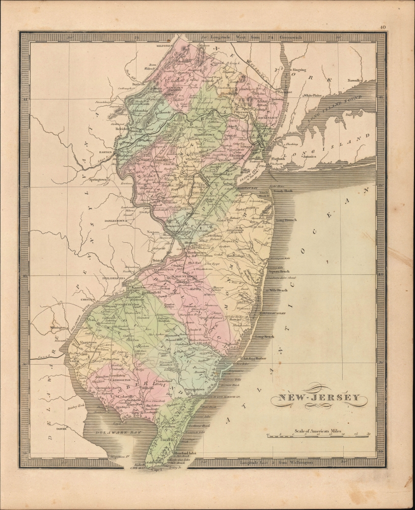
A superb example of Jeremiah Greenleaf's 1849 hand-colored map of New Jersey. Among other elements, it demonstrates the state's evolving industrial and transportation infrastructure, especially canals and railroads.
A Closer Look
New Jersey is depicted with color-coding at the county level, and with roads, railways, rivers, lakes, cities and towns, canals, ferry crossings, islands, lighthouses, and other features noted. Elevation is rendered by hachure. Portions of neighboring states and similarly detailed, including New York City, towards top-right, and Philadelphia, towards left. A close examination of the map reveals many interesting elements, such as early and unusual town names ('Snuff Town' in the state's north) and the concentration of early industrial forges (furnaces) in Burlington County.Marvelous Canals
Several features that stand out prominently here were technological marvels of their day. The Morris Canal, cutting across the northern portion of New Jersey, linking with the Delaware Canal and Lehigh Canal, allowed coal from Pennsylvania to be transported to New York Harbor (Easton, across the Delaware River from Philipsburg, is today home to the National Canal Museum). It used a system of locks and cables to climb a total of some 900 feet from east to west. The Delaware and Raritan Canal, Camden and Amboy Railroad, and Elizabethtown and Somerville Railroad (labeled only as 'Railroad') were aimed at building commercial and passenger links between New York City and Philadelphia, though ferries still had to be engaged at Trenton or Camden and at Jersey City to go between the urban centers.Publication History and Census
This map was published by Jeremiah Greenleaf in the scarce 1849 (last) edition of his New Universal Atlas. It is based on David Burr's 1835 original, which was published in the latter's atlas of the same name, before being inherited and updated by Greenleaf, who published it in several editions in the 1840s.CartographerS
Jeremiah Greenleaf (1791 - 1864) is a little known but highly admired American cartographer of the early 19th century. He published from roughly 1830 to 1850. His most important work is A New Universal Atlas; Comprising of all the Principal Empires, Kingdoms, and States Throughout the World and Forming a distinct Atlas of the United States, published in several editions in the 1840s. Many of his maps are reformatted versions of his contemporary David Burr's much admired cartographic works. Greenleaf's maps are extremely rare and admired for their stunningly vivid pastel color washes. More by this mapmaker...
David Hugh Burr (August 18, 1803 - December 25, 1875) of one of the first and most important truly American cartographers and map publishers. Burr was born in Bridgeport Connecticut in August of 1803. In 1822 Burr moved to Kingsboro, New York to study law. A year and a half later he was admitted to the New York Bar association. Burr must have questioned his choice of careers because shortly after being admitted to the Bar, he joined the New York State Militia. Though largely untrained in the art of surveying, Burr was assigned to work under Surveyor General of New York, Simeon De Witt, to survey several New York Roadways. Seeing a window of opportunity, Burr was able to negotiate with the governor of New York at the time, De Witt Clinton, to obtain copies of other New York survey work in order to compile a map and Atlas of the state of New York. Recognizing the need for quality survey work of its territory, the government of New York heartily endorsed and financed Burr's efforts. The resulting 1829 Atlas of the State of New York was the second atlas of an individual U.S. state and one of the most important state atlases ever produced. Burr went on to issue other maps both of New York and of the United States in general. In cooperation with publishing firm of Illman & Pillbrow, he produced an important New Universal Atlas and, with J.H. Colton, several very important maps of New York City. In recognition of this work, Burr was appointed both "Topographer to the Post office" and "Geographer to the House of Representatives of the United States". Later, in 1855, Burr was assigned to the newly created position of Surveyor General to the State of Utah. Burr retired from the position and from cartographic work in general in 1857 when light of some of his financial misdeeds and frauds came to light. He was accused of submitting false expense reports and underpaying employees, among other indiscretions. Learn More...
Source
Greenleaf, J., New Universal Atlas, (Brattleboro, Vermont: Greenleaf) 1849.
Condition
Good. Light foxing.
References
Rumsey 15176.044.