1861 Kitchell Wall Map of New Jersey
NewJersey-kitchell-1861$4,500.00


Title
Topographical map of the State of New Jersey together with the vicinities of New York and Philadelphia, and with most of the state of Delaware from the State Geological Survey and the U.S. Coast Survey, and from surveys by G. Morgan Hopkins, civil engineer.
1861 (dated) 69.5 x 58 in (176.53 x 147.32 cm) 1 : 158400
1861 (dated) 69.5 x 58 in (176.53 x 147.32 cm) 1 : 158400
Description
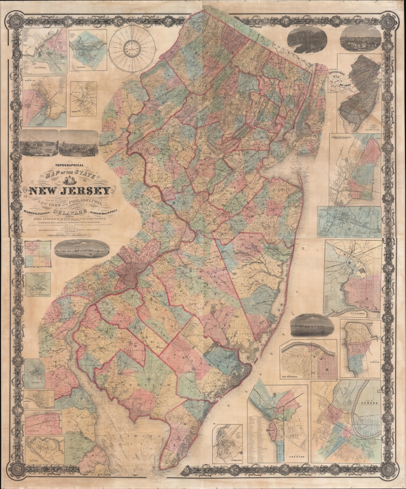
Magnificently detailed, visually stunning, and monumentally proportioned, this is William Kitchell's seminal 1861 wall map of New Jersey. This is the largest and most detailed map of New Jersey printed in the 19th century.
A Closer Look
This map covers the entire state of New Jersey as well as the Delaware Bay and adjacent parts of New York, Pennsylvania (particularly Philadelphia), and Delaware. Breathtaking detail throughout. The cartographers attempted to identify every road, hill, farm, hotel, post office, river, creek, swamp, store, distillery, and nearly every non-urban building in the state. The rivers, bays, and coastlines, especially around New York Harbor and the Delaware Bay, feature countless depth soundings and other nautical references no doubt derived from the work of the U.S. Coast Survey. The whole is surrounded by a grapevine-style border further embellished with floral motif decorative medallions.The Insets
In those large cities where marking individual buildings proved impossible, detailed insets are presented. The map features 17, from upper right: Paterson, Belvidere, Rahway, Morristown, Jersey City and Hoboken, Orange, Elizabeth, New Brunswick, Camden, Bordentown, Trenton, Newark, Salem, Burlington, Beverly, Newton, and Mount Holly. Additionally, there are several vignette views illustrating New Brunswick, Newark, the Delaware Water Gap, Paterson, Trenton, and Camden.Sources and History
Cartographically this map is derived from the earlier work of the State Geological Survey (from work commenced in 1836 under Henry Darwin Rogers), the U.S. Coast Survey (particularly for the Delaware Bay, New York Harbor, the New Jersey coastline, and in various river ways), and further survey work completed by the civil engineer G. Morgan Hopkins under the direction of William Kitchell, superintendent of the Geological Survey of New Jersey. Work on this map began by order of the legislature in 1854 when William Kitchell was installed as State Geologist. Kitchell began compiling the map with the assistance of his staff, which included George H. Cook (assistant Geologist), Henry Wurtz (Chemist and Mineralogist), and Egbert Viele (Topographical engineer). Two years later, in 1856, the New Jersey legislature, citing financial difficulties, suspended funding for the map and abolished the office of state geologist. Over the subsequent four years, Kitchell lobbied furiously for reinstatement and, in 1860, was granted permission to access the 'apparatus and materials belonging to the state survey' to, at his own expense, complete his grand map. The result, privately published later that year, is this awesome production, a landmark in the mapping of New Jersey and a significant advancement over the 1828 Gordon map.Publication History and Census
This map was first published in 1860 by H. G. Bond and William Kitchell. It is based on surveys compiled by Kitchell and G. M. Hopkins. The present example is the 1861 second edition. This map is scarce. The OCLC identifies two examples in the collections of Princeton University and the University of Massachusetts, Amherst. We have further identified examples at the New York State Library, the Fairleigh Dickinson University Library, and the Chester Public Library. There are three further examples in private hands. An important map for any serious collection focused on New Jersey.CartographerS
William Kitchell (April 21, 1827 - December 29, 1861) was a geologist and cartographer active in New Jersey during the middle part of the 19th century. Kitchell was born in East Madison, Morris County, New Jersey. He briefly studied at Rutgers College before dropping out to study medicine at the University of New York. He later took a position teaching Natural Sciences at the Newark Institute. Around 1850, finding his calling in this field, Kitchell proceeded to Germany in order to pursue a degree at the Mining School of Freiberg. On his return, in 1854, he was appointed to the office of State Geologist of New Jersey with a commission to produce a geological survey and accompanying topographical map of the state. A failure in legislative appropriations led to the position of State Geologist being abolished in 1860. Kitchell successfully lobbied for a reinstatement of the position and in 1860 was giving permission to continue work, though at his own expense, on his topographical map and geological survey. Later that year Kitchell published his cardinal work, the Topographical Map of New Jersey, arguably the largest and most detailed map of New Jersey ever made. One year later, in 1861, Kitchell unexpectedly died of an unknown acute illness, leaving his assistant, George H. Cook, to continue the Geological Survey, which was finally published in 1868. More by this mapmaker...
Griffith Morgan Hopkins (George M. Hopkins, G. M. Hopkins; 1834 - September 23, 1901) was an American Civil Engineer active in Philadelphia. Hopkins was born in Camden, New Jersey, and spent most of his career in Philadelphia. His earliest known map is the 1859 Clark and Tackabury map of Connecticut. He is also credited with work on the well-known Kitchell map of New Jersey (1860). In 1865, he partnered with his brother, Henry W. Hopkins (1838 - 1920), to found G.M. Hopkins and Company. This prosperous firm issued numerous plat maps and atlases of American cities and counties, most along the eastern seaboard. Hopkins retired from the firm in 1901 and died one year later. The firm was taken over by his brother, Henry, who himself retired in 1902. G. M. Hopkins went through numerous subsequent owners and remains active to this day. Learn More...
Robert Pearsall Smith (February 1, 1827 - April 17, 1898) was an American map maker active in Philadelphia from the middle to late 19th century. Smith was born to a Quaker family in Philadelphia, all librarians and publishers. Robert Pearsall originally ran a law bookstore at 19 James Street, Philadelphia. It was not until 1846 that Smith began producing maps in collaboration with this father, John Jay Smith, and brother, Lloyd P. Smith. One year earlier, in 1845, John Jay, then librarian at the Library Company of Philadelphia and Loganian Library, acquired the American rights to the anastatic process of transfer lithography. In February of 1846 he and his two sons founded the Anastatic Office, a printing concern based on the anastatic process located at 317 Market Street, Philadelphia. The Anastatic Office produced numerous copies and reissues of historic documents and maps from the Library Company's collection before being dissolved in 1847. In the same year Robert Pearsall opened a printing establishment under his own name at 144 Chestnut Street. In 1858, he joined forced with the Swiss-American engraver Frederick Bourquin (1808 - 1897) under the imprint 'F. Bourquin and Company' (602 Chestnut Street). Smith retired suddenly and inexplicably from the printing business around 1865. Smith was also deeply religious, a lay leader in the Holiness Movement in the United States and the Higher Life Movement in Great Britain. Smith and his wife, Hannah Tatum Whitall, first crossed the Atlantic to preach in England, Germany and Switzerland in 1873. They returned in 1875, preaching in Brighton, where Smith supposedly had an affair with an American writer. In, 1888, his entire family moved to England. Learn More...
Condition
Very good. Professionally devarnished with fresh linen backing.
References
Snyder, J. P., Mapping of New Jersey, p. 105. Dombroski, D. R., 'Brief History of the New Jersey Geological Survey', New Jersey Geological Survey Technical Memorandum, 1984. Barker, H., 'A Brief History of Some New Jersey Maps, 1654-1964', Mapping Digest for New Jersey, Bulletin 66, 1965 (New Jersey Geological Survey), p. 1-2. Cook, G., Annual Report of the State Geologist for the year 1885, (Trenton: New Jersey Geological Survey), p. 162.