This item has been sold, but you can get on the Waitlist to be notified if another example becomes available, or purchase a digital scan.
1910 Rand McNally Map of New Mexico w/ Railroads
NewMexico-randmcnally-1910$50.00

Title
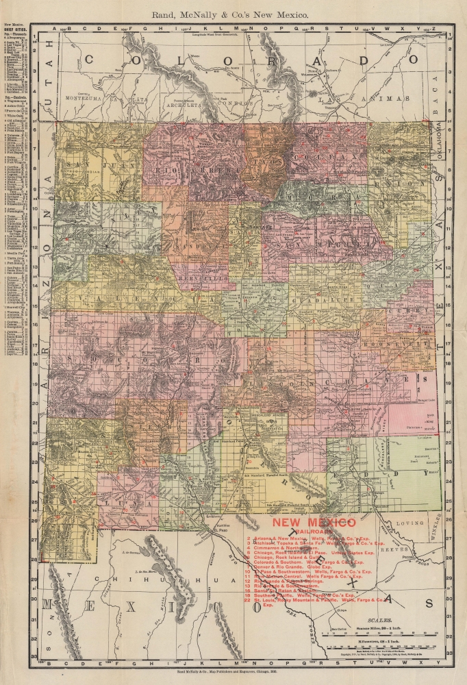
Rand McNally and Co.'s New Mexico.
1910 (dated) 19.75 x 13.5 in (50.165 x 34.29 cm) 1 : 1900800
1910 (dated) 19.75 x 13.5 in (50.165 x 34.29 cm) 1 : 1900800
Description
This is a 1910 Rand McNally and Company map of New Mexico Territory, published two years before statehood. With impressive detail, the map emphasizes New Mexico's extensive railroad network.
A Closer Look
Published during New Mexico territorial period, the map provides details townships, counties, cities, land grants, reservations, and most importantly, railroads.Railroads
For those interested in transportation history, this map provides interesting insight. New Mexico territory's railroad network is laid out in impressive detail, with every line labeled. Fourteen rail lines are emphasized with red overprinting and correspond with an index. Among these are 9 express services, including 5 Wells Fargo Express trains. These include the Atchison, Topeka, and Santa Fe; the Colorado and Southern; the El Paso and Southwestern; the Southern Pacific; and the St. Louis, Rocky Mountain and Pacific.Publication History and Census
This map was created and published by Rand McNally in 1910. While Rand McNally likely published editions of this map regularly, we note only one cataloged example of the present 1910 edition which is part of the collection at the Universitätsbibliothek Erfurt in Erfurt, Germany.Cartographer
Rand, McNally and Co. (fl. 1856 - present) is an American publisher of maps, atlases and globes. The company was founded in 1856 when William H. Rand, a native of Quincy, Massachusetts, opened a print shop in Chicago. Rand hired the recent Irish immigrant Andrew McNally to assist in the shop giving him a wage of 9 USD per week. The duo landed several important contracts, including the Tribune's (later renamed the Chicago Tribune) printing operation. In 1872, Rand McNally produced its first map, a railroad guide, using a new cost effective printing technique known as wax process engraving. As Chicago developed as a railway hub, the Rand firm, now incorporated as Rand McNally, began producing a wide array of railroad maps and guides. Over time, the firm expanded into atlases, globes, educational material, and general literature. By embracing the wax engraving process, Rand McNally was able to dominate the map and atlas market, pushing more traditional American lithographic publishers like Colton, Johnson, and Mitchell out of business. Eventually Rand McNally opened an annex office in New York City headed by Caleb S. Hammond, whose name is today synonymous with maps and atlases, and who later started his own map company, C. S. Hammond & Co. Both firms remain in business. More by this mapmaker...
Condition
Very good. Light wear along original fold lines. Accompanied by original binder.
References
OCLC 837980830.