
1948 Stedman Pictorial Map of New Mexico

This item has been sold.
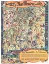
Recreational Map of New Mexico The Land of Enchantment.
Visit New Mexico - the Land of Enchantment.
- Digital Map Information
- Suitable for large format printing
- Full resolution TIFF file
- ICC color profile embedded
- Delivered instantly via download link
Visit New Mexico - the Land of Enchantment.
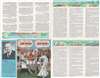
This is a 1948 Wilfred Stedman pictorial map of New Mexico. The map depicts the state of New Mexico from Shiprock to El Paso. Many recreational areas, national monuments, and various points of interest are identified including Chaco Canyon, Gran Quivira, Acoma the sky city, Aztec Ruins, White Sands, and Carlsbad Caverns National Park. Stedman's map also identifies Billy the Kid country, the Grave of Billy the Kid, Apache country, several fossil beds, lava beds, caves, rivers, and lakes. Fantastically illustrated with cowboys, Native American Indians, vacationers, birds, animals, and Spanish dancers, Stedman uses stereotypes of the American Southwest to appeal to potential tourists. In the upper right, Stedman marks the 'Four Corners', the only point in the United States common to four states, where the boundaries of Utah, New Mexico, Arizona and Colorado meet. The lower right features a short note entitled 'Make Your Vacation a Real Adventure.' Information about monuments, parks, sports, climate, and other topics appears on the verso.Publication History and Census
The map was prepared and illustrated by Wilfred Stedman and published by the New Mexico State Tourist Bureau, a division of the State Highway Department in 1948. This map is well represented in institutional collections.Cartographer
Wilfred Stedman (1892 – 1950) was an English architect and illustrator active in Santa Fe, New Mexico in the first half of the 20th century. Born in Liverpool, Stedman later moved to New Mexico where he fell in love with the culture and natural beauty of the American southwest. Stedman's works include WPA projects and numerous collaborations with his wife, Myrtle Stedman, on such subjects as adobe houses, design, and southwestern architecture. Further Details...
Condition
Very good. Exhibits light wear along original fold lines. Verso repair to a fold separation in margin. Text on verso.
References
OCLC 427908802.