This item has been sold, but you can get on the Waitlist to be notified if another example becomes available, or purchase a digital scan.
1827 Map of New Mexico and the Colorado Territory
NewMexico-vandermaelen-1827-2$400.00

Title
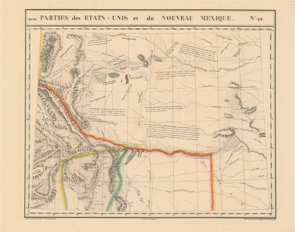
Parties des Etats-Unis et du Nouveau Mexique. Amer. Sep. no. 48.
1827 (undated) 18.5 x 22 in (46.99 x 55.88 cm) 1 : 1641836
1827 (undated) 18.5 x 22 in (46.99 x 55.88 cm) 1 : 1641836
Description
This is 1827 Vandermaelen map of the American-Mexican frontier of the Missouri Territory, shown during a period of active exploration. It was the largest-scale map of this region produced to date - 'no mapmaker had previously attempted to use such a large scale for any western American area.' (Wheat). Like all of the maps from Vandermaelen's Atlas, it is the also the first map of the region executed in lithograph.
On the Map
The map shows what would become Colorado, New Mexico and Nebraska. Santa Fe is shown along with neighboring villages, including Taos. Castle Rock in Colorado is shown, near Bell's Springs (now occupied by Bell's Springs.) The map includes tribal routes, cities and settlements, and notes the region that would eventually become Yellowstone Park. New Mexique, it should be noted, refers to the region under Mexican government: the northern part of the map shows part of the Missouri Territory, in particular the areas that would become Nebraska and Colorado. The map captures the region in its frontier period - many Native American tribes are shown with their populations noted. There are some notes pertaining to the Pike expedition, and a very full treatment of the 1820 expedition of Stephen Harriman Long.The Long Expedition
The track of Long's 1820 expedition up the Platte River to the Rocky mountains is shown on the map, which - though not the first to show the journey - is the best-focused cartographic document of it. Due to the large scale afforded by this map, the expedition's track is shown in comparable, or even greater detail than Long's own (much smaller) map published with his report in 1823, including many descriptive texts reporting the geology of the land as well as the populations and disposition of the Native American tribes encountered.Publication History
This map appeared in the fourth part, 'Quatrième partie, Amér. sept.' of Vandermaelen's Atlas universel de géographie physique, politique, statistique et minéralogique. The atlas was produced in one edition in 1827; only 810 complete sets were sold. The full set of six volumes appears in eleven institutional collections in OCLC; the 4th volume alone is listed in 9. This map is listed as a separate only in the Clements Library, New Mexico State University, the University of Texas at Arlington, and the Amon Carter Museum of American Art.Cartographer
Philippe Marie Guillaume Vandermaelen (December 23, 1795 - May 29, 1869) was a Flemish cartographer active in Brussels during the first part of the 19th century. Vandermaelen is created with "one of the most remarkable developments of private enterprise in cartography," namely his remarkable six volume Atlas Universel de Geographie. Vandermaelen was born in Brussels in 1795 and trained as a globe maker. It was no doubt his training as a globe maker that led him see the need for an atlas rendered on a universal scale in order that all bodies could be understood in relation to one another. In addition to his great work Vandermaelen also produced a number of globes, lesser maps, a highly detailed 250 sheet map of Belgium, and several regional atlases. More by this mapmaker...
Source
Vandeermaelen, P. Atlas universel de geographie physique, politique, statistique et mineralogique (Bruxelles, Vandermaelen) 1827.
Condition
Very good condition. Area of faint toning near upper centerfold, else excellent.
References
Rumsey 2212.000. OCLC 78320444. Wheat, C.I. Mapping the transmississippi West, 378; Streeter, T.W. Bibliography of Texas 1795-1845, 1095. Phillips, 749. Koeman Vdm 1. National Maritime Museum, 179. Wellens-De Donder, L. Philippe Vandermaelen 1795-1869, 4-5.