This item has been sold, but you can get on the Waitlist to be notified if another example becomes available, or purchase a digital scan.
1899 U.S.C.G.S. Nautical Chart of Long Island Sound from Throgs Neck to New Rochelle
NewRochelleThrogsNeck-uscgs-1899$275.00

Title
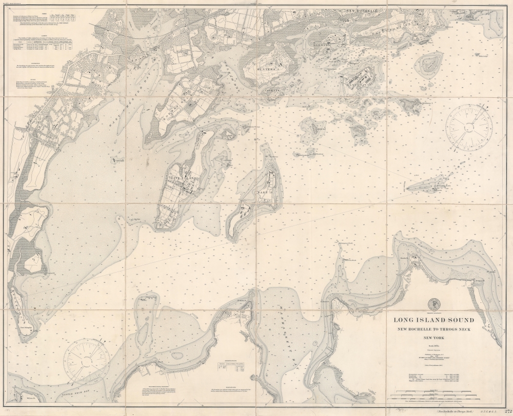
Long Island Sound. New Rochelle to Throgs Neck. New York.
1899 (dated) 35 x 43.25 in (88.9 x 109.855 cm) 1 : 10000
1899 (dated) 35 x 43.25 in (88.9 x 109.855 cm) 1 : 10000
Description
This is an 1899 U.S. Coast and Geodetic Survey nautical map of part of Long Island Sound from Throgs Neck to New Rochelle.
A Closer Look
Oriented toward the northwest, New Rochelle and Davenport Neck appear at top right. Glen Island, Hunters Island, Davids Island, City Island, and Hart Island are illustrated in the Sound. Depth soundings fill the Sound, and rocks and other navigation hazards are labeled. Part of the north coast of Long Island occupies most of the bottom border, with Little Neck Bay and Manhassett Bay labeled. Throgs Neck appears along the left border. Roads and railroads are illustrated throughout. Buildings noted include Neptune House, a grand resort hotel built in 1837, located just below New Rochelle. One section of the hotel still stands and has been divided into four private homes.Publication History and Census
This map was created and published by the U.S. Coast and Geodetic Survey during the superintendency of Henry S. Pritchett. We note a single cataloged example of the 1899 edition which is part of the collection at the British Library. This chart was first published in 1895, of which four examples are referenced in OCLC.CartographerS
The Office of the Coast Survey (1807 - present) founded in 1807 by President Thomas Jefferson and Secretary of Commerce Albert Gallatin, is the oldest scientific organization in the U.S. Federal Government. Jefferson created the "Survey of the Coast," as it was then called, in response to a need for accurate navigational charts of the new nation's coasts and harbors. The spirit of the Coast Survey was defined by its first two superintendents. The first superintendent of the Coast Survey was Swiss immigrant and West Point mathematics professor Ferdinand Hassler. Under the direction of Hassler, from 1816 to 1843, the ideological and scientific foundations for the Coast Survey were established. These included using the most advanced techniques and most sophisticated equipment as well as an unstinting attention to detail. Hassler devised a labor intensive triangulation system whereby the entire coast was divided into a series of enormous triangles. These were in turn subdivided into smaller triangulation units that were then individually surveyed. Employing this exacting technique on such a massive scale had never before been attempted. Consequently, Hassler and the Coast Survey under him developed a reputation for uncompromising dedication to the principles of accuracy and excellence. Unfortunately, despite being a masterful surveyor, Hassler was abrasive and politically unpopular, twice losing congressional funding for the Coast Survey. Nonetheless, Hassler led the Coast Survey until his death in 1843, at which time Alexander Dallas Bache, a great-grandson of Benjamin Franklin, took the helm. Bache was fully dedicated to the principles established by Hassler, but proved more politically astute and successfully lobbied Congress to liberally fund the endeavor. Under the leadership of A. D. Bache, the Coast Survey completed its most important work. Moreover, during his long tenure with the Coast Survey, from 1843 to 1865, Bache was a steadfast advocate of American science and navigation and in fact founded the American Academy of Sciences. Bache was succeeded by Benjamin Pierce who ran the Survey from 1867 to 1874. Pierce was in turn succeeded by Carlile Pollock Patterson who was Superintendent from 1874 to 1881. In 1878, under Patterson's superintendence, the U.S. Coast Survey was reorganized as the U.S. Coast and Geodetic Survey (C & GS) to accommodate topographic as well as nautical surveys. Today the Coast Survey is part of the National Oceanic and Atmospheric Administration or NOAA as the National Geodetic Survey. More by this mapmaker...
Henry Smith Pritchett (April 16, 1857 - August 28, 1939) was an American astronomer and educator. Born in Fayette, Missouri, Pritchett attended Pritchett College in Glasgow, Missouri and graduated with a B.A. in 1875. He then spent two years at the U.S. Naval Observatory under the tutelage of Asaph Hall, after which he became an assistant astronomer. He returned to Glasgow in 1880 for a job at the Morrison Observatory, where his father was the director. In 1882, Pritchett served as an astronomer on the Transit of Venus Expedition to New Zealand, and was appointed as a professor of mathematics and astronomy at Washington University in St. Louis upon his return in 1883. While at Washington University, Pritchett also served as the director of the observatory. Pritchett studied in Germany in the early 1890s and earned a PhD from the University of Munich in 1894. From December 1, 1897 until November 30, 1900, Pritchett was the Superintendent of the U.S. Coast and Geodetic Survey, and then was president of the Massachusetts Institute of Technology (MIT) from 1900 until 1906. After leaving MIT, Pritchett served as the president of the Carnegie Foundation for the Advancement of Teaching from 1906 until he retired in 1930. Learn More...
Condition
Very good. Dissected and mounted on linen in 16 panels.
References
OCLC 556428630.