This item has been sold, but you can get on the Waitlist to be notified if another example becomes available, or purchase a digital scan.
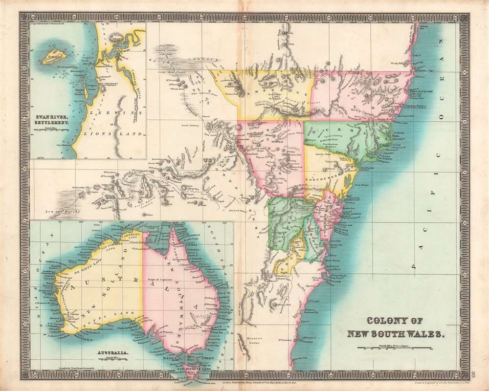
1831 Dower Map of New South Wales, Australia
NewSouthWales-dower-1831$200.00

Title
Colony of New South Wales, Swan River Settlement, Australia.
1831 (undated) 12.25 x 15.5 in (31.115 x 39.37 cm) 1 : 2400000
1831 (undated) 12.25 x 15.5 in (31.115 x 39.37 cm) 1 : 2400000
Description
This is the Teesdale / John Dower's brilliantly colored 1831 map of Australia, with a focus on the Colony of New South Wales. It illustrates the territory as it was rapidly developing and transitioning from a penal colony to a society of free settlers.
Overall, this map captures Australia as it quickly transitioned from a land inhabited by Aboriginal peoples to a penal colony ruled by a military governor, and again to a settlement with laws, representative government, and civil society organizations.
Historical Context
At the time this map was made, the British population was small and mostly confined to a handful of coastal towns, but was growing quickly. Several expeditions in the early 19th century mapped out routes through the Blue Mountains, but, as can be seen here, much of Australia remained terra incognita. In the 1820s, significant settlements sprang up west of Sydney at Bathurst and Wellington (the latter noted simply as 'Depot'). Colonies were also established in western Australia (Swan River, later Perth, in an inset at top-left) and soon afterwards in southern Australia (based at Adelaide, near Kangaroo Island and Cape Jervis, marked in the inset of the entire continent at bottom-left), joining the existing colony at Van Diemen's Land (Tasmania).Overall, this map captures Australia as it quickly transitioned from a land inhabited by Aboriginal peoples to a penal colony ruled by a military governor, and again to a settlement with laws, representative government, and civil society organizations.
Publication History and Census
This map was engraved by John Dower for the 1831 edition of A New General Atlas of the World, published by Henry Teesdale. This appears to be an especially rare presentation of Dower's Australia map, not matching any of the examples in the David Rumsey Historical Map Collection or other major digital repositories. Although undated, it almost certainly is an example from 1831, as the Swan River Settlement was established in 1829 and then incorporated into the new Colony of Western Australia in 1832. Since the latter term is not present here, the map likely was published between these two dates. Also, it does not include the Colony of South Australia, split off from New South Wales in 1836. The map is only cataloged in the holdings of four institutions in Australia and the United Kingdom, though as stated above the present map is likely to be distinct from those examples in coloration and presentation.CartographerS
John James Dower (June 1, 1825 - 1901) was a well-respected mapmaker, print seller, and publisher based in London, England. Dower is the heir to the more prominent London engraver and mapmaker John Crane Dower (1791 - 1847). Dower worked with many prominent middle to late 19th century London map publishers including Weller, Cassell, Bacon, Petermann, and others. He was elected to the Royal Geographical Society in 1854. Dower also published on maps his own account including one atlas and various school geographies. In addition to his cartographic work, Dower is well known as an engraver of military scenes. More by this mapmaker...
Henry Teesdale (December 1776 - January 1856) was a British map publisher active in the first half of the 19th century. Teesdale was born in London. He was elected to the Royal Geographical Society in 1830. Teesdale initially partnered with John Hordan and William Colling Hobson as Henry Teesdale and Company, but this partnership was dissolved in 1832. Afterwards Teesdale continued to publish maps and atlases on his own account. He worked with several major British map engravers of the period including John Crane Dower, Christopher Greenwood, and Josiah Henshall, among others. His most prominent work is a large map of the world engraved by Dower. He must have enjoyed considerable commercial success because in 1845 he is registered as a partner in the Royal Bank of Scotland. Teesdale died in January of 1856 and was buried in All Souls, Kensal Green. Learn More...
Source
John Dower, A New General Atlas of the World..., (London: Henry Teesdale) 1831.
Condition
Very good. Some discoloration around central fold line.
References
OCLC 219938568.