This item has been sold, but you can get on the Waitlist to be notified if another example becomes available, or purchase a digital scan.
1874 Dripps Map of the Bays, Harbors and Rivers around New York City, New York
NewYork-asheradams-1874$200.00

Title
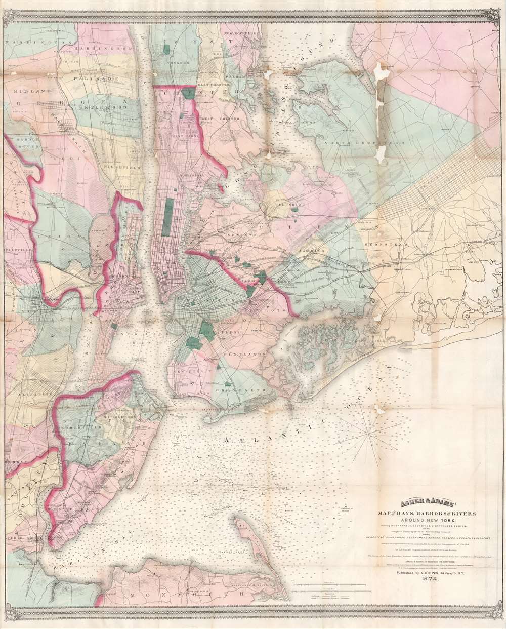
Asher and Adams' Map of the Bays, Harbors and Rivers Around New York: Showing the Channels, Soundings, Lighthouses, Buoys etc. and the Complete Topography of the Surrounding Country: including Hempstead, Sandy-Hook, South-Amboy, Newark, Yonkers, N. Rochelle and Glenn Cove.
1874 (dated) 33.25 x 27.25 in (84.455 x 69.215 cm) 1 : 84480
1874 (dated) 33.25 x 27.25 in (84.455 x 69.215 cm) 1 : 84480
Description
This is a visually striking and rare 1874 Matthew Drips and Asher and Adams map of the greater New York City area. Innovatively combining detailed land surveys with the work of the U.S. Coast Survey, the map depicts the New York City area from Sandy Hook and Monmouth County, north to include Staten Island, Newark, Manhattan and Yonkers. Coverage extends eastward into Long Island as far as Hicksville, Jericho and Freeport. All of Brooklyn, Jamaica Bay, and Queens are illustrated, along with parts of Westchester and much of northeastern New Jersey. The farmlands, islands, swamps, and parks of the region are also illustrated. The Croton Aqueduct appears as a thin black line in Westchester and the Bronx. Nautically, this map is heavily based upon the 1856 U.S. Coast survey of the same region compiled under the direction of A. D. Bache. It includes thousands of depth soundings and notes channels, buoys, and lighthouses where appropriate.
Publication History and Census
This map was created and published by Matthew Dripps working in conjunction with the Asher and Adams. Three editions of this map were produced. Dripps published the first edition in 1866. He published an updated edition in 1871 that extended the coverage area further east. The third edition, of which the offered example is representative, was published jointly by Dripps and Asher and Adams in 1874. An example of this rare third edition is cataloged in OCLC and is part of the collection at the New York Public Library.CartographerS
Matthew Dripps (1812 – April 9, 1896) was an Irish-born American mapmaker active in Philadelphia and New York during the second half of the 19th century. Dripps was born in Gracefield, Ireland. In Ireland, probably Belfast, he worked as a grocer. Dripps immigrated to American from Belfast on the Patrick Henry in 1849, arriving in Philadelphia, where he connected with the Reformed Presbyterian Church and worked briefly as a tax collector. His earliest recorded maps, depicting Philadelphia, appeared during this period. Dripps relocated to Brooklyn, New York in 1850, setting up shop as a map publisher. His two largest maps were published in the following years, 1850 and 1851, and combine to form an enormous map of Manhattan. These gained him the attention of the City Council, who used his maps for census and government work. Afterwards, he issued other large format New York City and Brooklyn maps as well as smaller maps for the New York City Clerk's office. He was married to Ameila Millar Dripps with whom he had six children, among them Amelia Dripps and the clergyman Joseph Frederick. Dripps is interred at Greewood Cemetery, Brooklyn. More by this mapmaker...
The Office of the Coast Survey (1807 - present) founded in 1807 by President Thomas Jefferson and Secretary of Commerce Albert Gallatin, is the oldest scientific organization in the U.S. Federal Government. Jefferson created the "Survey of the Coast," as it was then called, in response to a need for accurate navigational charts of the new nation's coasts and harbors. The spirit of the Coast Survey was defined by its first two superintendents. The first superintendent of the Coast Survey was Swiss immigrant and West Point mathematics professor Ferdinand Hassler. Under the direction of Hassler, from 1816 to 1843, the ideological and scientific foundations for the Coast Survey were established. These included using the most advanced techniques and most sophisticated equipment as well as an unstinting attention to detail. Hassler devised a labor intensive triangulation system whereby the entire coast was divided into a series of enormous triangles. These were in turn subdivided into smaller triangulation units that were then individually surveyed. Employing this exacting technique on such a massive scale had never before been attempted. Consequently, Hassler and the Coast Survey under him developed a reputation for uncompromising dedication to the principles of accuracy and excellence. Unfortunately, despite being a masterful surveyor, Hassler was abrasive and politically unpopular, twice losing congressional funding for the Coast Survey. Nonetheless, Hassler led the Coast Survey until his death in 1843, at which time Alexander Dallas Bache, a great-grandson of Benjamin Franklin, took the helm. Bache was fully dedicated to the principles established by Hassler, but proved more politically astute and successfully lobbied Congress to liberally fund the endeavor. Under the leadership of A. D. Bache, the Coast Survey completed its most important work. Moreover, during his long tenure with the Coast Survey, from 1843 to 1865, Bache was a steadfast advocate of American science and navigation and in fact founded the American Academy of Sciences. Bache was succeeded by Benjamin Pierce who ran the Survey from 1867 to 1874. Pierce was in turn succeeded by Carlile Pollock Patterson who was Superintendent from 1874 to 1881. In 1878, under Patterson's superintendence, the U.S. Coast Survey was reorganized as the U.S. Coast and Geodetic Survey (C & GS) to accommodate topographic as well as nautical surveys. Today the Coast Survey is part of the National Oceanic and Atmospheric Administration or NOAA as the National Geodetic Survey. Learn More...
Asher and Adams (fl. c. 1860 - c. 1900) were New York based cartographers active in the latter part of the 19th century. Active in the 1860s and 70s, the New York firm of Asher & Adams produced some of the most detailed and colorful late 19th century American Atlases. Asher & Adams are known for their remarkable state and county atlases which are so detailed that they include individual family homes and names. The Asher & Adams firm followed the quality and style formats pioneered by the earlier Colton and Johnson firms - notable for their distinctive pastel color washes and impressive size. Their most important work is their 1874 Asher & Adams Commercial and Statistical Gazetteer of the United States which is one of the first 19th century atlases to remove topographical information to make room for detailed depictions of railroads. Learn More...
Condition
Good. Has undergone some professional restoration work and has been backed with Japanese paper. However, has also been refolded at some point. Some minor damage and loss along a couple of the original fold lines - especially in the upper right quadrant. Would flatten beautifully.
References
Haskell, D. C., Manhattan Maps: A Co-operative List, no. 1268. Phillips (America) p. 538. American Geographical Society Library, 862.1 B-1871 (1866 edition). OCLC 317117996.