This item has been sold, but you can get on the Waitlist to be notified if another example becomes available, or purchase a digital scan.
1807 Bridges and Maverick Map of New York City
NewYork-bridgesmaverick-1807$1,750.00

Title
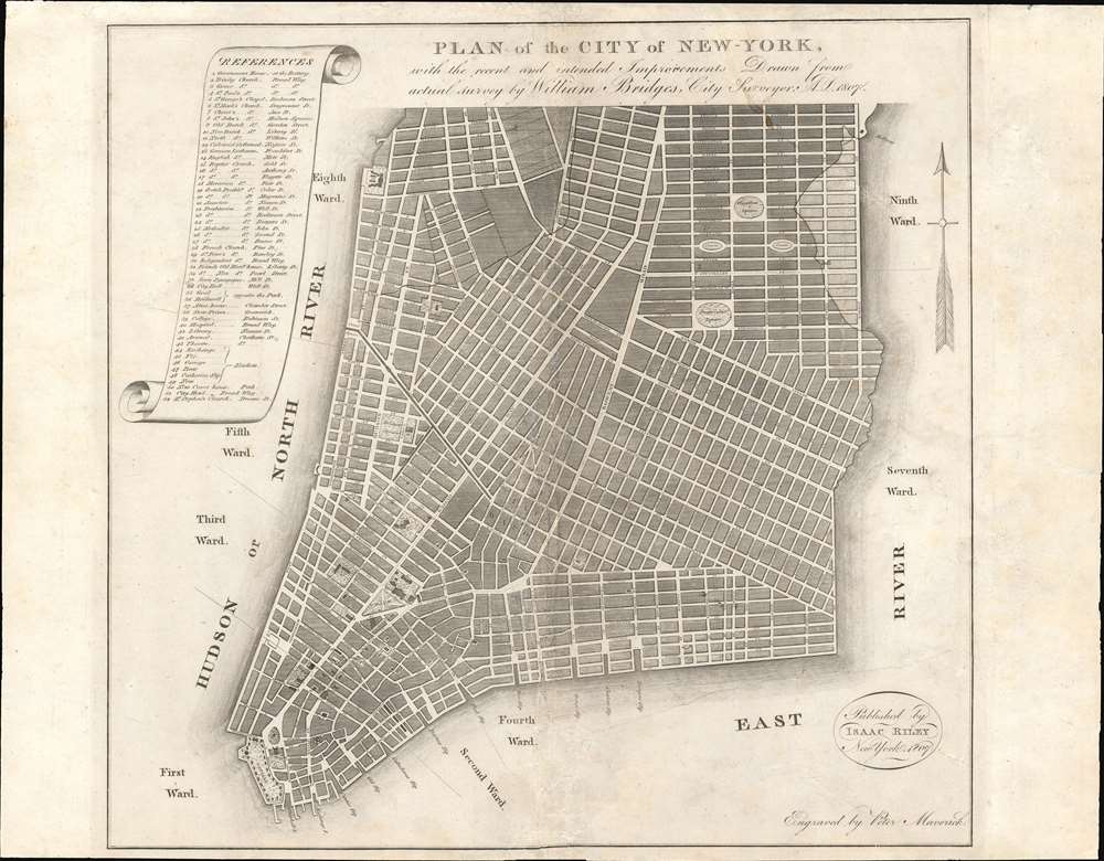
PLAN of the CITY OF NEW-YORK, with the recent and intended Improvements. New York, 1807.
1807 (dated) 12.5 x 13.5 in (31.75 x 34.29 cm) 1 : 17200
1807 (dated) 12.5 x 13.5 in (31.75 x 34.29 cm) 1 : 17200
Description
This is a highly unusual piece with a confused and complex history. The map was published in 1807 by Isaac Riley, William Bridges, and Peter Maverick. It depicts lower Manhattan from roughly Bank Street (current West Village) to the Bowery, but is cartographically unusual as it follows the Mangin-Goerck Plan, a much larger c. 1801 map also engraved by Peter Maverick. That, plan, like the present map, proposed extensive landfill projects and new streets intended to generate clean neat lines and sharp right angles throughout. It is of note that this map pre-dates the 1811 Commissioner's Plan, and thus represents the definitive plan of New York City at the time of publication. This map is thus the only obtainable examples of one of the most important founding cartographic documents relating to the development of New York's street grid, publishing while the Mangin-Goerck map was still relevant.
The recent outbreak of Yellow Fever underscored the dangers of allowing such a city to grow haphazardly without central planning. Lower Manhattan was a hodge-podge of streets and narrow alleys built at odd angles, much in the spirit of old European capitals. This congestion, combined with swampy terrain, harsh winters, sweltering summers, and a lack of sanitation, led to the unorganized urban space being a breeding ground for epidemic level disease. Even so, the city was rapidly expanding northwards, absorbing great farming estates into sprawling unregulated private developments. By 1799 these developments absorbed the Bayard Farm, the Delancey Estate, and parts of the Stuyvesant Farms, breaking them into discordant grids and selling off lots. Riley himself lived in one of these new houses in what is today Greenwich Village.
No one was more aware of the problem the veteran city surveyor Casmir Goerck and French emigre Charles Mangin, who jointly lobbied the Common Council to finance the first official city plan since the American Revolutionary War. With earlier plans being obsolete and near useless, Goerck and Mangin began the onerous task of resurveying the entire city. The work took years, during which time Goerck contracted malaria and died, leaving the plan to Mangin. Mangin was bold and visionary, and under his pen, what began as a simple administrative real-estate map, became a blueprint for future development. His plan took into account the existing developments, both public and private, and incorporated them into a bold new plan extending the street grid well beyond the developed area into what where then unceded farming estates.
In the words of Gerard Koeppel in City on a Grid,
BUT, in 1807, the Commissioner's Plan was still a distant dream. What they had was the Mangin-Goerck Plan. When Dr. Samuel Mitchell (1764 - 1831) approached the New York publisher Isaac Riley for a map to illustrate his Picture of New York, Riley reached out to City Surveyor William Bridges to replicate, at a reduced scale, the dominant if not officially sanctioned, Mangin-Goerck Plan. Bridges contracted Maverick, who was intimately acquainted with the Mangin-Goerck Plan, as well as the city's premier engraver, to produce the map. Then, as in 1801, it was understood that this was not a map of New York as it was, but rather 'as it was to be'.
The Mangin-Georck Plan
It is impossible to understand this Riley / Bridges plan without first understanding the precursor Mangin-Goerck map. At the end of the 18th century, following the American Revolutionary War, the population of New York was increasing exponentially and the city's developed area growing at a breakneck pace. The Common Council, which governed New York was well aware that while the city of 1797 was still a small by European standards, within a few years, it would become major global metropolis.The recent outbreak of Yellow Fever underscored the dangers of allowing such a city to grow haphazardly without central planning. Lower Manhattan was a hodge-podge of streets and narrow alleys built at odd angles, much in the spirit of old European capitals. This congestion, combined with swampy terrain, harsh winters, sweltering summers, and a lack of sanitation, led to the unorganized urban space being a breeding ground for epidemic level disease. Even so, the city was rapidly expanding northwards, absorbing great farming estates into sprawling unregulated private developments. By 1799 these developments absorbed the Bayard Farm, the Delancey Estate, and parts of the Stuyvesant Farms, breaking them into discordant grids and selling off lots. Riley himself lived in one of these new houses in what is today Greenwich Village.
No one was more aware of the problem the veteran city surveyor Casmir Goerck and French emigre Charles Mangin, who jointly lobbied the Common Council to finance the first official city plan since the American Revolutionary War. With earlier plans being obsolete and near useless, Goerck and Mangin began the onerous task of resurveying the entire city. The work took years, during which time Goerck contracted malaria and died, leaving the plan to Mangin. Mangin was bold and visionary, and under his pen, what began as a simple administrative real-estate map, became a blueprint for future development. His plan took into account the existing developments, both public and private, and incorporated them into a bold new plan extending the street grid well beyond the developed area into what where then unceded farming estates.
In the words of Gerard Koeppel in City on a Grid,
In sum, Mangin's plan of the city 'such as it is to be' was a synthesizing of patterns already establishing themselves at the suburban fringes of the city and, in the city proper, an orderly filling in east and west with linear streets out to continuous roads along the waterfronts. The city government hadn't asked for it, but it seemed to be just what was wanted.Initially it appeared that the Common Council was pleased with Mangin's work. This suddenly changed in 1803, likely, as Koeppel suggests, due to political maneuvering between rival parties and petty revenge against Mangin for winning the prestigious contract to design New York's first city hall. It does not, again referencing Keoppel, appear to have been an outright rejection of Mangin's vision or the plan itself. Thus, until recently, the Mangin-Goerck map is regularly dismissed as the common academic perception was that the map was fantastical, rejected by the Common Council as false, and never adopted. As Koeppel points out in City on a Grid, this could not be further from the truth. In fact, the plan was followed meticulously south of Houston (North) Street. According to Koeppel,
…everything he laid out became actual city streets, many with his chosen names, but for the upper portion of his expanded Bayard grid and his expanded Stuyvesant grid with its near-true east-west axis. What seems to have happened is that regardless of whatever its official status map have been, without another plan, Mangin's became the de facto plan - if not the 'new map of the city,' the 'sort of map of the city'.
The 1807 Bridges / Riley / Maverick Map
Moving forward in time by 4 years. Between the release of the Mangin-Goerck Plan and 1807, the city continued to develop and expand - largely in accordance with that plan. It is no mistake that in 1807, the year this map was published, that the Common Council created the Commission of Streets and Roads and ordered an even more expansive and futuristic plan that, under master surveyor John Randel Jr., would extend the grid well into upper Manhattan. The resultant map, published by Bridges and Maverick in 1811, was known as the Commissioner's Plan.BUT, in 1807, the Commissioner's Plan was still a distant dream. What they had was the Mangin-Goerck Plan. When Dr. Samuel Mitchell (1764 - 1831) approached the New York publisher Isaac Riley for a map to illustrate his Picture of New York, Riley reached out to City Surveyor William Bridges to replicate, at a reduced scale, the dominant if not officially sanctioned, Mangin-Goerck Plan. Bridges contracted Maverick, who was intimately acquainted with the Mangin-Goerck Plan, as well as the city's premier engraver, to produce the map. Then, as in 1801, it was understood that this was not a map of New York as it was, but rather 'as it was to be'.
Publication History and Census
This map was prepared by William Bridges, engraved by Peter Maverick, and published by Isaac Riley. It was intended for publication in Dr. Mitchell's Picture of New York. The present example, appears be a proof or a separate issue, not intended for insertion into the book - which would have required a more complex fold meteoric, as the book was a smallish sextodecimo size. The present map exhibits evidence of only a centerfold. The map was briefly resurrected in lithograph and published in John Hardy's 1870 (published 1871) Manual of the Corporation of the City of New York wherein it illustrated a reissue of Englishman John Lambert's 1807 - 1808 essay describing the aspect, people, climate, and economy of New York City.CartographerS
William Bridges (1771 - July 10, 1814) was a surveyor and cartographer active in New York City early in the 19th century. Bridges was born in England. He must have arrived in the United States between 1805 and 1806. In 1806 he is advertising his services as a tutor in architectural drawing for young ladies and gentlemen. Bridges was a Federalist and was accused of election fraud when he attempted to force others to vote for his candidates. In cartographic spheres, Bridges is best known for his publication of New York City's grid structure in his important 1811 Commissioner's Plan of New York. The Commissioner's Plan is considered to be 'the single most important document in New York City's development' (Augustyn & Cohen). Unfortunately Bridges had little to do with the actual construction of the Commissioner's plan having stolen credit for the work from the actual surveyor, John Randel Jr. (1787 - 1865). Although Randel is credited for the Commissioner's Plan, it was Bridges who profited on the original issue and successfully held the copyright. In 1807, Bridges also issued an edition of the Mangin-Goerck Plan of New York City, attaching his own name to it as the 'Bridges Plan', and publishing it in a picture guide to New York. He died in 1814, shortly after publishing his version of the Commissioner's Plan, and is buried in St. Paul's Churchyard, Manhattan. More by this mapmaker...
Peter Maverick (October 22, 1780 – June 7, 1831) was a New York City engraver active in the early part of the 19th century. Peter Maverick is best known engraving several seminal maps of New York City, including the Mangin-Goerck plan of 1803, the Bridges Plan of 1807, and Commissioner's Plan of 1811. Maverick mastered engraving under the tutelage of his father, Peter Rushton Maverick (1755 – 1811), a well known New York engraver in his own right. He was active as an engraver from roughly 1802, when he married Mary Griffin and graduated from his apprenticeship, to 1817. Maverick took his own apprentice, Asher Brown Durand, from 1812 to 1817. Once Durand graduated form his apprenticeship, five years later, he and Maverick established a partnership which lasted until about 1820. Maverick's first shop was located at 68 Beekman Street, New York. He later recoated to Frankfort Street and then to successive locations on Nassau Street. Peter Maverick died of a heart attack on June 7th of 1831. Learn More...
Joseph-Francois Mangin (June 10, 1758 - 1818) was an architect, city surveyor, and civil engineer active in New York during the late 18th and early 19th century. Mangin was born in Vosages, France, the son of Jean-Baptiste François Mangin, the king's surgeon. He went to both high school and University in Nancy, graduating in 1781. He apprenticed under Ange-Jacques Gabriel in the design of the Place de la Concorde, Paris. He then traveled to the French colony of Saint Domingue (Haiti), presumably to make his fortune, but was force to flee in 1793 because of the 1792 Haitian Revolution (1792 - 1796). By this time the French Revolution was well underway, Mangin's family, royalists all, were arrested and executed at the guillotine. Mangin came to New York city in 1786 as a refugee, but quickly acquired the patronage of Alexander Hamilton, and was admitted as a Freeman of New York on May 9, 1796. He submitted several projects to the Common Council of New York, including a recommendation to drain the Collect Pond and various improvements to the port facilities. In 1797, he was commissioned, along with fellow surveyor Casimir Goerck, to make a large scale plan of New York City - the first since American independence. He presented the plan to the Common Council in 1801. While the council initially approved of the plan, it was dismissed in 1803 due to anti-Hamilton political maneuvering. Nonetheless, the Mangin-Goerck Plan, which proposed landfill work and a new street grid, was highly influential. Mangin is also today credited with the principal design of New York's first City Hall although fellow designer, John McComb unilaterally denied Mangin's claims in an attempt to steal credit for the work. Mangin remained favorite with the Common Council and was commissioned to work on the 1811 Commissioner's Plan of New York City, a truly meritorious work that laid out the permanent street grid for most of Manhattan. Mangin left New York in 1818, presumably back to France, and is believe to have died there. Learn More...
Isaac Riley (November 29, 1770 - March 14, 1824) was a New York City based book publisher and shipping merchant active in the early 19th century. Riley was born in Berlin, Connecticut. The earliest substantial refence we have found regarding Riley is from 1802, when he is recorded as a shipping agent based at 63 Pine Street, New York. It is not clear when he established his shipping business, or how it was run, but one report notes he owned sixteen vessels, suggesting considerable wealth. From at least 1805 to 1806 he ran Isaac Riley and Company, at 1 City-Hotel, Broadway, a printer and seller of legal books. This firm was sold in December 1806 to Brisban and Brannan. From roughly 1807 he had a new bookshop and printing office at the intersection of Wall Street and William Street, from which he published travel narratives, maps, and guides, as well as imported popular books from Europe. Riley was considered a major publisher, for a time touted as the 'largest in New York with a stock worth at least $400,000.' Nonetheless, when the War of 1812 led to a major recession, he, like many other publishers, was forced into bankruptcy. He recovered and was in business again by 1815. Around 1820 he relocated to Philadelphia, establishing his business there. He also was heavily invested in Maine real estate, where he is reported to have owned 'Ketcham' and 'Riley' townships. He established a colony of settlers from Philadelphia in Maine in 1823, traveling there with them. He died in Maine one year later, in 1824. Learn More...
Source
Mitchell, S., Picture of New York (New York: Riley) 1807.
Condition
Good. Laid down on archival tissue.
References
OCLC 26115396. Koeppel, G, City on a Grid, pages 29 - 71. Haskel, D. C., Manhattan Maps, A Co-operative List, 643. Augustyn, R. T., Cohen, P., Manhattan in Maps 1527 - 1995, p. 96-99. New York Public Library, Map Division, Map Div. 88-5214.