1965 New York Convention and Visitors Bureau Pictorial Map of Manhattan, New York City
NewYork-conventionbureau-1965$225.00

Title
New York Guide Touristique et Carte.
1965 (dated) 11 x 25.75 in (27.94 x 65.405 cm)
1965 (dated) 11 x 25.75 in (27.94 x 65.405 cm)
Description
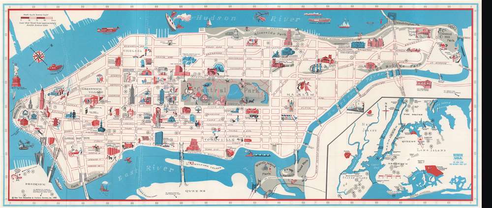
This is a 1965 New York Convention and Visitors Bureau pictorial map of Manhattan, New York City, issued for the 1964 - 1965 World's Fair. Pictorial icons mark landmarks from the Battery to Inwood Hill Park, including the Empire State Building, the American Museum of Natural History, Lincoln Center, and the United Nations. The Museum of Modern Art, the Guggenheim, and the Metropolitan Museum of Art appear alongside Columbia University, Hunter College, the New School, and New York. One of the lions in front of the New York Public Library overlooks Fifth Avenue. An inset in the lower right provides a regional context and highlights the World's Fair grounds, LaGuardia, Newark, and J.F.K. airports.
Publication History and Census
This map was created for and published by the New York Convention and Visitors Bureau in 1965. We note two cataloged examples. One is part of the Donovan Clarke Map Collection at the National Library of Australia and the other appears in OCLC at the Erfgoedbibliotheek Hendrick Conscience in Antwerp, Belgium.Condition
Very good. Light wear along original fold lines. Text and printed photographs on verso. Trimmed along bottom, likely removing text below the map.
References
'New York Guide Touristique et Carte, 1965', Donovan Clarke Map Collection, National Library of Australia, Item 21. OCLC 901320579.