1907 Hotel Booklet City Map or Plan of Manhattan, New York City
NewYork-hotelbooklet-1907$300.00

Title
New Map of New York.
1907 (dated) 6.25 x 19.5 in (15.875 x 49.53 cm) 1 : 27700
1907 (dated) 6.25 x 19.5 in (15.875 x 49.53 cm) 1 : 27700
Description
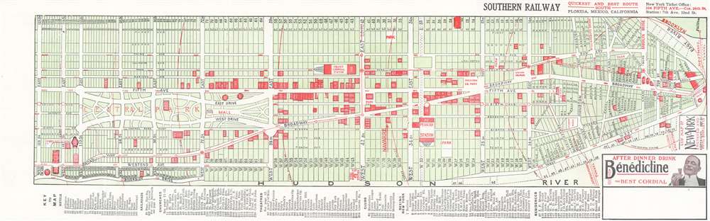
This is a 1907 Hotel Booklet Company city plan or map of Manhattan in New York City. The map depicts the borough from 125th Street to Battery Park and from First Avenue to the Hudson River. All the major streets are labeled, as are Washington Square Park, Madison Square Park, and Central Park. Over 220 different locations throughout Manhattan are illustrated in red and numerically identified, each of which corresponds with an index included along the bottom of the map, Some of the referenced sites include hotels, churches, theatres, and clubs, as well as tourist destinations such as the Metropolitan Museum of Art, the stock exchange, Grant's Tomb, Columbia University, and the Central Park Zoo, referenced here as the menagerie. Major subway lines are illustrated, though remain unlabeled, and references mark the Williamsburg Bridge, Manhattan Bridge, and Brooklyn Bridge.
Publication History and Census
This map was created and published by the Hotel Booklet Company in 1907. The OCLC records this map as being part of only one institutional collection at Stony Brook University.Condition
Very good. Light wear along original fold lines. Text on verso.
References
OCLC 24053976.