This item has been sold, but you can get on the Waitlist to be notified if another example becomes available, or purchase a digital scan.
1933 Mora Pictorial Map of New York City
NewYorkandHarbor-mora-1933$75.00

Title
New York and Harbor.
1933 (undated) 7 x 4.5 in (17.78 x 11.43 cm)
1933 (undated) 7 x 4.5 in (17.78 x 11.43 cm)
Description
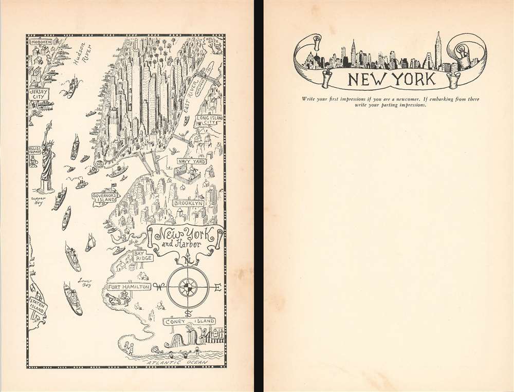
This is a delightful 1933 Jo Mora pictorial map of New York City. The map depicts the region from Jersey City to Long Island City and from Central Park to Coney Island and the Atlantic Ocean. True to the aesthetic he cultivated over the course of his career, Mora employs numerous comic vignettes to illustrate this work. The New York Aquarium, then located in Battery Park, is marked simply by a goldfish in a fishbowl. Manhattan's elevated railway, now a thing of the past, curves around Lower Manhattan near Battery Park as well, evoking a note of nostalgia in the modern viewer. Hell Gate, though labeled, is marked by the devil brandishing a pitchfork. All four East River bridges are not illustrated as the wonders of modern engineering that they are, rather as four very simple foot bridges, complete with steps on either end. A man is illustrated fishing off of the Manhattan Bridge, while another figure pushes a wheelbarrow across the Queensboro Bridge.
Mora highlights the Brooklyn Navy Yard, labeled here as simply 'Navy Yard', but doesn't choose to Forth Hamilton in southern Brooklyn is marked by a doughboy (identifiable by his hat) is preparing to fire a cannon into The Narrows, and Coney Island is marked by a carnival barker and a rollercoaster. A very cheerful Statue of Liberty is illustrated greeting the ships entering and exiting the harbor, with an immigrant standing behind her on Ellis Island, then the nation's busiest immigration station.
On a more serious note, Manhattan's iconic, and ever-changing, skyline is highlighted, with the. Empire State Building in the center. Central Park, near the top border, is filled with trees and has a vehicle of some kind illustrated driving through it. Manhattan's many piers along the Hudson River are full, highlighting New York's economic importance and its stature as the largest city in the world. Jersey City and Hoboken are labeled in New Jersey, while the boroughs of Staten Island and Brooklyn are identified in New York.
The verso is mostly blank, but features a wonderful illustration of the New York skyline and a prompt to use the space as a diary entry, 'Write your first impressions if you are a newcomer. If embarking from there write your parting impressions.'
Publication History
This map was created and published by Jo Mora in 1933. A similar edition was published in a volume by Mora, but this example was almost certainly a separate issue due to the verso content.Cartographer
Joseph 'Jo' Jancito Mora (October 22, 1876 – October 10, 1947) was an Uruguayan born artist active in California during the first half of the 20th century. Mora immigrated to California as a young man. He studied art in Boston and, after graduating, worked there briefly before relocating to California. In cartographic circles Mora is known for pioneering the 20th century pictorial map. In a series he referred to as his 'cartes,' published between in 1926 and 1942, Mora developed a pictorial style that combined cartography with colorful cartoonish image of local figures, folklore, history, and natural wonders. His earliest maps were commissioned by the Hotel Del Monte and included California's Playground and The Seventeen Mile Drive. As he matured as a cartographer, his work became increasingly dense, often packed with tiny figures, each expressive of some aspect of regional life. Mora, often called the 'Renaissance man of the West' also worked as an illustrator, muralist, sculptor, photographer, and writer. His masterpiece is considered to be the Father Serra Cenotaph, a bronze and marble sculpture at the Memorial Chapel in El Carmelo Mission, Carmel, California. His map work included Monterey Penninsula (1927), and Seventeen Mile Drive (1927), California (1927), Grand Canyon (1931), Yosemite (1931), Yellowstone (1936), Carmel-By-The-Sea (1942), California (1945) (large and small versions), Map of Los Angeles (1942), among others. More by this mapmaker...
Condition
Very good. Even overall toning. Light soiling. Text on verso.
References
Rumsey 8632.009.