This item has been sold, but you can get on the Waitlist to be notified if another example becomes available, or purchase a digital scan.
1865 Dripps Map or Plan of New York City and Vicinity
NewYorkAndVicinity-dripps-1865-3$300.00

Title
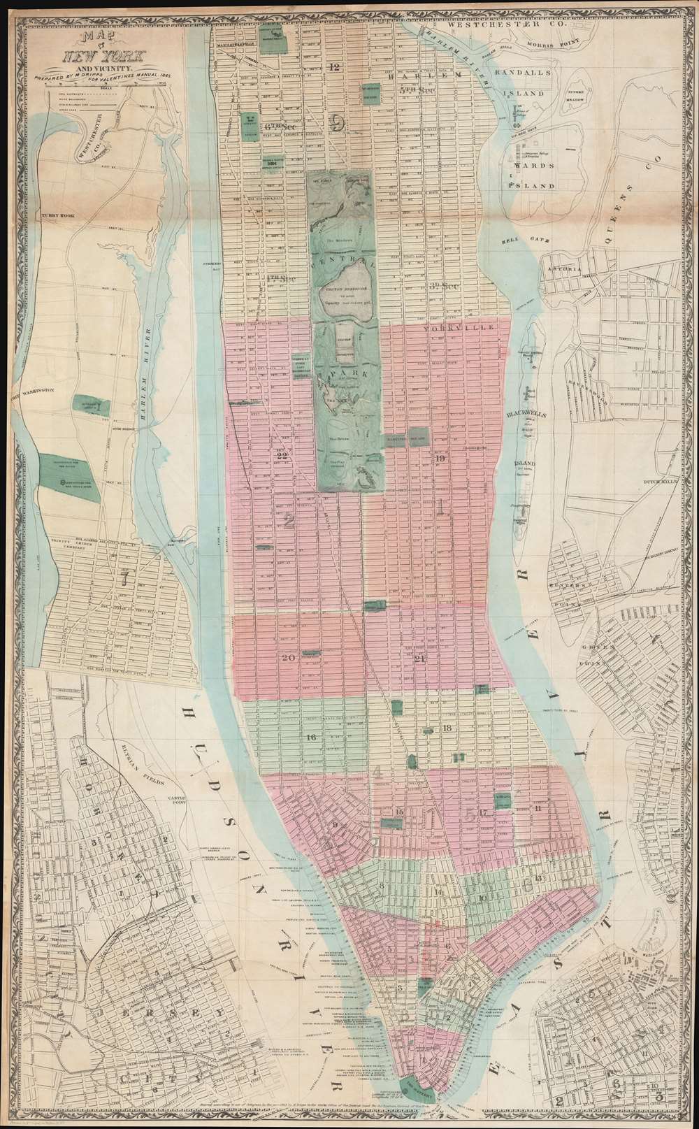
Map of New York and Vicinity.
1865 (dated) 34 x 21 in (86.36 x 53.34 cm) 1 : 17000
1865 (dated) 34 x 21 in (86.36 x 53.34 cm) 1 : 17000
Description
This is a scarce large format 1865 plan or map of New York City by Matthew Dripps. It depicts the island of Manhattan as well as parts of Brooklyn, Queens, Hoboken, and Jersey City. The map illustrates the city in considerable detail with all streets and, in Manhattan, block numbers clearly identified. An inset along the left border details the northern portion of Manhattan. The map labels most of the piers in lower Manhattan and shows numerous individual buildings with identifying numbers. Where Columbia University now stands, this map reveals a 19th century Lunatic Asylum. In Queens, Dripps labels Hunters Point and presents the beginnings of the Long Island Railroad. Astoria is delineated. Central Park is mapped in detail exhibiting the fully glory of Olmsted's plan.
19th Century Urban Development in New York
The mid-19th century was a dynamic period in the urban development of New York City. Under the governance of Tammany Hall and the corrupt 'Boss' Tweed, New York City had become a mélange of extremes. By 1864 the Five Points had devolved into the world's most notoriously dangerous slum, while further north the high ideals and design genius of Frederick Law Olmsted and Calvert Vaux created Central Park, the world's first and possibly finest planned public recreation area. Meanwhile, across the East River, Brooklyn, Greenpoint, and Williamsburg consolidated into a single city, becoming the third largest city in the United States, and setting the stage for the emergence of the modern New York City.Publication History and Census
Dated 1865 under the title, the copyright at the bottom left reads 'Entered according to Act of Congress in the year 1865 by M. Dripps in the Clerk's Office of the District Court for the Southern District of New York'. It was prepared by Matthew Dripps for issue in David Valentine's 1865 Manual of the Common Council of New York.CartographerS
Matthew Dripps (1812 – April 9, 1896) was an Irish-born American mapmaker active in Philadelphia and New York during the second half of the 19th century. Dripps was born in Gracefield, Ireland. In Ireland, probably Belfast, he worked as a grocer. Dripps immigrated to American from Belfast on the Patrick Henry in 1849, arriving in Philadelphia, where he connected with the Reformed Presbyterian Church and worked briefly as a tax collector. His earliest recorded maps, depicting Philadelphia, appeared during this period. Dripps relocated to Brooklyn, New York in 1850, setting up shop as a map publisher. His two largest maps were published in the following years, 1850 and 1851, and combine to form an enormous map of Manhattan. These gained him the attention of the City Council, who used his maps for census and government work. Afterwards, he issued other large format New York City and Brooklyn maps as well as smaller maps for the New York City Clerk's office. He was married to Ameila Millar Dripps with whom he had six children, among them Amelia Dripps and the clergyman Joseph Frederick. Dripps is interred at Greewood Cemetery, Brooklyn. More by this mapmaker...
David T. (Thomas) Valentine (1801 - 1869) served as the Clerk of the Common Council of New York City. He edited and published a series of New York City almanacs and fact books entitled Manual of the Corporation of The City of New York. Valentine's Manual, as it came to be called, included facts about the City of New York, City Council information, city history, and reported on the progress of public works such as Central Park. The production of this annual manual was the responsibility of the Clerk of the City of New York, a position held at different times by D. Valentine and by Joseph Shannon (fl. c. 1850 - 1869), who also produced a similar manual. Valentine used his manual to reproduce some of the rarest and most important maps of New York City ever created. Learn More...
Source
Valentine, D., Valentine's Manual of the Corporation of the City of New York, (New York) 1865.
Condition
Good. Small area of infill to top margin top third; left margin extended with some impact to border. Verso repairs at junctures of folds. Original wash color.
References
Haskell, D., Manhattan Maps: A Co-operative List, #1154.