1852 Magnus Map of New York City and Brooklyn
NewYorkBrooklyn-magnus-1852$950.00

Title
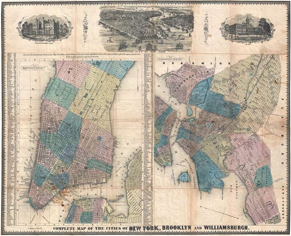
Complete Map of the Cities of New York, Brooklyn and Williamsburgh.
1852 (undated) 18 x 22.5 in (45.72 x 57.15 cm) 1 : 31000
1852 (undated) 18 x 22.5 in (45.72 x 57.15 cm) 1 : 31000
Description
An exceptionally scarce 1852 map of New York City by Charles Magnus. Essentially two maps on one sheet. The left-hand map focuses on Manhattan and adjacent parts of Brooklyn. It extends northwards as far as 51st street. The right-hand map focuses on Brooklyn and Williamsburg when they were separate cities. It depicts Williamsburg as far as Morril Street and extends westward south of Division Avenue (current day Broadway) as far as Gowanus Bay and 59th Street. It extends eastward as far as Montgomery Street and Greenwood cemetery. The map is bounded by Bushwick on the north and Flatbush on the east. Throughout, both maps illustrate streets, important buildings, parks, city wards, piers, ferries, and rail lines. Surmounting the map there are three engraved views illustrating the University, Washington Square (future NYU), Manhattan as seen from the south, and New York's City Hall.
Publication History and Census
This map was engraved and issued by Charles Magnus in 1852. We note approximately 8 examples held institutionally. Scarce to the market.Cartographer
Charles Magnus (1826 - 1900) was a New York City based stationer, illustrator, bookseller, and map and print publisher active in the middle to late 19th century. Magnus was born in Elberfeld, Germany, as Julian Carl Magnus. Fleeing the March Revolution in Germany, the Magnus family immigrated to New York City in 1848. In New York, Charles' brother Carl Emil had already established himself as the editor of a German weekly newspaper, Deutsche Schnellpost. It was through his brother that Magnus learnt the printing and publishing trade. The earliest work to bear the Magnus inscription dated to the 1850s and includes various pictorial broadsides and maps intended to commemorate important events - the most notable for map enthusiasts being his 1855 map of New York commemorating the '79th Year of Independence of the United States'. During the 1860s and years of the American Civil War, Magnus, through various political connections, became one of the few illustrators with unrestricted access to Union military camps. He is consequently particularly well known for his authentic view of Civil War cities, personages, and events. Following the war, Magnus began to develop a prosperous business creating and selling panoramic city views, song sheets, and patriotic envelopes. In all Charles Magnus, with over 1000 known works, was one of the most prolific American printers of broadsides and other lithographs. More by this mapmaker...
Condition
Very good. Backed on archival tissue for stability. Closed tear extending approximately 1.5 inches into the printed area from left margin along with other minor closed tears along left margin. Light soiling. Blank on verso.
References
Haskell, D., Manhattan Maps: A Co-operative List, 962. OCLC 40996790. Brooklyn Library, MAP_1852-01-01.