This item has been sold, but you can get on the Waitlist to be notified if another example becomes available, or purchase a digital scan.
1917 Rand McNally Railroad Map of the United States
NewYorkCentral-randmcnally-1917$87.50

Title
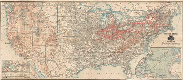
United States Showing the New York Central Railroad and Connections.
1917 (dated) 17 x 38.75 in (43.18 x 98.425 cm) 1 : 5385600
1917 (dated) 17 x 38.75 in (43.18 x 98.425 cm) 1 : 5385600
Description
This is a 1917 Rand McNally and New York Central Railroad map of the United States. The map depicts the United States from the Pacific Ocean to the Atlantic Ocean and from Canada to Mexico. A railroad map at its core, the entire rail network in the continental United States is illustrated and the New York Central Railroad is highlighted in thick red lines. Every stop along the lines operated by the New York Central is labeled, from Boston to St. Louis and from Montreal, Canada and Mackinaw City, Michigan to Cairo, Illinois. Major stops along rail lines throughout the United States are also labeled, and so are the companies responsible for their operation. Rivers, lakes, and mountain ranges throughout the U.S. are also labeled. 'Pleasure resorts throughout the country' are also indicated by small red dots. An inset map in the lower right corner illustrates the Atlantic Ocean and the surrounding countries. Transatlantic steamship lines are illustrated and labeled, with the majority running between New York or Boston and cities in England. There are several lines running from the United States to Panama as well, an area of particular interest as the Panama Canal opened only three years before this map was published. An inset map on the lower corner illustrates the Panama Canal Zone and provides a profile of the Canal Zone as well.
This map was produced by Rand McNally and published by the New York Central Railroad in 1917.
This map was produced by Rand McNally and published by the New York Central Railroad in 1917.
Cartographer
Rand, McNally and Co. (fl. 1856 - present) is an American publisher of maps, atlases and globes. The company was founded in 1856 when William H. Rand, a native of Quincy, Massachusetts, opened a print shop in Chicago. Rand hired the recent Irish immigrant Andrew McNally to assist in the shop giving him a wage of 9 USD per week. The duo landed several important contracts, including the Tribune's (later renamed the Chicago Tribune) printing operation. In 1872, Rand McNally produced its first map, a railroad guide, using a new cost effective printing technique known as wax process engraving. As Chicago developed as a railway hub, the Rand firm, now incorporated as Rand McNally, began producing a wide array of railroad maps and guides. Over time, the firm expanded into atlases, globes, educational material, and general literature. By embracing the wax engraving process, Rand McNally was able to dominate the map and atlas market, pushing more traditional American lithographic publishers like Colton, Johnson, and Mitchell out of business. Eventually Rand McNally opened an annex office in New York City headed by Caleb S. Hammond, whose name is today synonymous with maps and atlases, and who later started his own map company, C. S. Hammond & Co. Both firms remain in business. More by this mapmaker...
Condition
Good. Backed on archival tissue for stability. Slight loss along top margin. Blank on verso.
References
OCLC 884585921.