This item has been sold, but you can get on the Waitlist to be notified if another example becomes available, or purchase a digital scan.
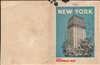
1926 Crosby Pictorial Map of Manhattan, New York City
NewYorkCity-arthurcrosby-1926$600.00


Title
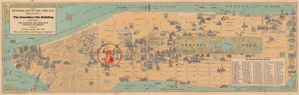
Pictorial Map of New York City Showing the Location of the Guardian Life Building Home of the Guardian Life Insurance Company of America.
1926 (dated) 11.5 x 37.5 in (29.21 x 95.25 cm) 1 : 32000
1926 (dated) 11.5 x 37.5 in (29.21 x 95.25 cm) 1 : 32000
Description
Created at the height of Prohibition in the United States, this 1926 Arthur Crosby Service and Guardian Life Insurance Company of America pictorial map of New York City highlights the locations of nearly two dozen speakeasies in Greenwich Village. Focusing on the island of Manhattan, signature buildings throughout the borough are illustrated in profile, with the Guardian Life Building highlighted in red overprinting. Streets are labeled, as are parks and the Holland Tunnel.
Speakeasies
Speakeasies proliferated in Greenwich Village during Prohibition (1920 - 1933). Twenty small icons dot the neighborhood and are curiously unlabeled, the only illustrations on the map not identified. Through our research, we have surmised that these must be some of the neighborhood's most famous speakeasies. For example, the horse at 11th and Hudson Streets is almost certainly the White Horse Tavern, while the pirate at 10 Sheridan Square must be the Pirate's Den owned by Don Dickerman. The cat at the corner of Bedford and Barrow Streets is likely the famous speakeasy Chumley's (of which there is a modern reincarnation at the same spot!). The pot on Charles Street between Bleecker and West 4th is likely Jack's, and the eagle on Hudson might be the Beatrice Inn, but we are not certain. Other icons that we haven't identified a witch riding a broomstick, an owl, a snake, and a teapot.Why Greenwich Village?
Greenwich Village and the West Village were popular for speakeasies because these neighborhoods had easy access to smuggled alcohol coming up the Hudson from the Atlantic. It also appears that it was easier for independent operators to gain police protection from organized crime syndicates in the Village than in other parts of the city.New York's Most Famous and Infamous Sites
Pictorial illustrations of New York's most well-known sites populate Manhattan, including The Metropolitan Museum of Art, the American Museum of Natural History, Pennsylvania Station (before it was demolished), Trinity Church, Columbia University, and Grand Central Station. Central Park is illustrated in detail and includes a profile view of the obelisk. Hotels, churches, and other monuments are also named. The most eye-catching of these, however, must be the Chase National Bank branches, which are all printed in red. The mansions of the rich and famous line Fifth Avenue and theatres throughout the Theatre District are labeled. The Tombs, an infamous prison, is also labeled.The S.S. Leviathan
The S.S. Leviathan is illustrated at Pier 84 along the Hudson River, one of two 'berths' set aside for her (the other was Pier 86). Leviathan was built as the Vaterland ('Fatherland' in German) and was the second of three sister ships built for transatlantic service for Germany's Hamburg America Line. She sailed for the German American Line for less than a year, making her maiden voyage in May 1914, before being stranded in New York Harbor by World War I, where she sat at a dock in Hoboken for nearly three years. When the U.S. entered the war in April 1917, she was seized by the U.S. government and soon handed over to the U.S. Navy. The Navy began operating her, and in September 1917, she was renamed USS Leviathan by President Woodrow Wilson. Leviathan made numerous transatlantic voyages during the war and was even painted with British 'dazzle' camouflage. By the end of the war, she had transported over 119,000 men. The USS Leviathan was decommissioned in 1919 and handed over to the U.S. Shipping Board in October of that year. Now, Leviathan was refitted as a luxury ocean liner and set out on her maiden voyage in July 1923 with 3,000 passengers. The SS Leviathan traversed the Atlantic numerous times a year until 1931, when, because of the Great Depression, it became evident that she could not turn a profit. Once again, Leviathan was relegated to a dock in Hoboken beginning in June 1933 and would sit there until 1937, when British Metal Industries Ltd bought her for scrap.Publication History and Census
This map was created by the Arthur Crosby Service and published by the Guardian Life Insurance Company of America in 1926. Several different editions of this map were published between at least 1926 and 1928 by Arthur Crosby Service for different organizations. One was published for Chase National Bank and red overprinting marked Chase Bank branches across Manhattan. Another used red overprinting to highlight the Paramount Building. This is the only known cataloged example of the present edition published by the Guardian Life Insurance Company of America.Cartographer
The Arthur Crosby Service Inc. (fl. c. 1921 - c. 1935) was an American publisher operating in New York City. The Arthur Crosby Service published folder, booklets, and general advertising. They specialized in writing advertising for restaurants, hotels, antique dealers, and decorators. More by this mapmaker...
Condition
Very good. Light wear along original fold lines. Small areas of infill at fold intersections and in margins.