
This item below is out of stock, but another example (left) is available. To view the available item, click "Details."
Details
1835 Burr Map of New York City and Vicinity (25 miles around)
1835 (dated) $600.00
1842 Burr City Map of New York City w/ manuscript farm boundaries
NewYorkCity-burr-1842$1,750.00

Title
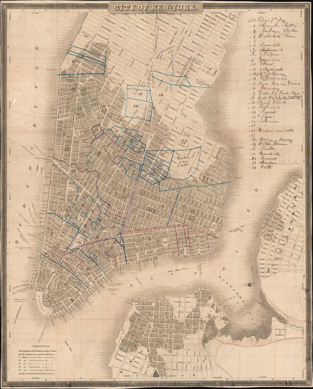
City of New York.
1842 (undated) 22 x 17.75 in (55.88 x 45.085 cm)
1842 (undated) 22 x 17.75 in (55.88 x 45.085 cm)
Description
This is a c. 1842 David Burr and Edward Walker pocket-style city map of southern Manhattan, New York City, with meticulous manuscript annotation detailing pre-grid farm boundaries. These unique annotations mark an important moment in Manhattan's history, when the city was being lotted according to the grid system, and fortunes could be made by savvy real-estate investors capable of capitalizing on the complex history of New York land ownership. In addition, this is one of the few known maps to name the African American Burial Ground between Duane and Reade Streets.
Manuscript Farm Boundaries
While the map itself is not uncommon, the addition of early farms in manuscript lends this piece considerable significance. After the adoption of the Commissioner's Plan in 1811, a real-estate boom began in New York, as old family estates, some dating to the Dutch period, were appropriated (with compensation) under eminent domain, and the city lotted for development. Those who understood the old farm boundaries, and the complex network of ownership changes and inheritances that divided them in the late 18th and early 19th centuries, could build fabulous real-estate fortunes. This map was likely previously owned and used by a lawyer, surveyor, or real-estate speculator. Here thirty-four estates, most associated with pre-grid farms, represent some of New York's most prominent names, including Bayard (22), Rutgers (8), Beekman (3), Roosevelt (11), Delancey (12 and 13), Grovesenor (9), and Herring (28), among others, many of which remain indelibly integrated into New York geography. Other noted locations include Trinity Church (20), and the 'Negro Burying Ground' (15).African American Burial Ground
This is one of the few historic maps to mark the African American Burial Ground, noted here as 'Negro Burying Ground' located between Duane and Reade Streets in Manhattan. Known today as the African Burial Ground National Monument, the excavation of this site was called the 'most important historic urban archeological project in the United States.' In the 17th and 18th centuries some 15000 African Americans were buried here, making it the largest and earliest known African American cemetery in the United States. The site was designated a National Historic Landmark in 1993 and a National Monument in 2006 by President George W. Bush.Publication History
This map was engraved by Samuel Stiles and Company and published by David H. Burr and Edward Walker c. 1842. Burr issued this map in various states from 1834 to 1845 in conjunction with two separate publishers, Edward Walker (114 Fulton Street) and J. H. Colton (172 William Street). The Colton variants are sometimes dated, but Walker did not put a date stamp on his issues, thus making this map very difficult to pinpoint. What we do know is that later issues contained a legend in the lower left, which appears here marking it as a later edition. The present example, due to the annotations, is unique.CartographerS
David Hugh Burr (August 18, 1803 - December 25, 1875) of one of the first and most important truly American cartographers and map publishers. Burr was born in Bridgeport Connecticut in August of 1803. In 1822 Burr moved to Kingsboro, New York to study law. A year and a half later he was admitted to the New York Bar association. Burr must have questioned his choice of careers because shortly after being admitted to the Bar, he joined the New York State Militia. Though largely untrained in the art of surveying, Burr was assigned to work under Surveyor General of New York, Simeon De Witt, to survey several New York Roadways. Seeing a window of opportunity, Burr was able to negotiate with the governor of New York at the time, De Witt Clinton, to obtain copies of other New York survey work in order to compile a map and Atlas of the state of New York. Recognizing the need for quality survey work of its territory, the government of New York heartily endorsed and financed Burr's efforts. The resulting 1829 Atlas of the State of New York was the second atlas of an individual U.S. state and one of the most important state atlases ever produced. Burr went on to issue other maps both of New York and of the United States in general. In cooperation with publishing firm of Illman & Pillbrow, he produced an important New Universal Atlas and, with J.H. Colton, several very important maps of New York City. In recognition of this work, Burr was appointed both "Topographer to the Post office" and "Geographer to the House of Representatives of the United States". Later, in 1855, Burr was assigned to the newly created position of Surveyor General to the State of Utah. Burr retired from the position and from cartographic work in general in 1857 when light of some of his financial misdeeds and frauds came to light. He was accused of submitting false expense reports and underpaying employees, among other indiscretions. More by this mapmaker...
Samuel Stiles (July 15, 1796 - April 3, 1861) was a New York based engraver of maps and bank notes active in the middle part of the 19th century. Stiles was born in East Windsor, Connecticut, and there served his apprenticeship as a line-engraver under self-taught master Abner Reed. In 1821, following his apprenticeship, Stiles relocated to Hartford, Connecticut, with is former master, Abner Reed, to form the firm of Reed and Stiles. Reed and Stiles worked in portrait, historical, landscape, and map engraving on wood and copper. Another former Reed apprentice, Pelton, joined the firm in 1822, changing the name of the firm to Reed, Stiles, and Pelton. Around this time, he also joined the Connecticut State Militia where he was commissioned as a corporal in the same Calvary regiment as his brother Asabel Chapin Stiles. In 1824, he relocated to Utica, New York, where worked with Vistus Balch, also a former Reed apprentice. Stiles and Balch moved to New York together in 1828 to found Balch and Stiles, banknote engravers. In 1833, Samuel Stiles partnered with Joseph Hutchins Colton, then a young man, to found Stiles and Company – Colton being the 'company.' This partnership lasted until 1836 when he and Colton published their great plan of New York City, known as the 'Colton Map.' Colton went his own way and became a major American map publisher. Stiles moved a few blocks away and partnered with George E. Sherman and Colin Smith to found Stiles, Sherman and Smith. The partnership dissolved in 1840 and Stiles took up again with J. H. Colton, who was already becoming prominent. In 1841, he joined the firm of Danforth, Ball, and Company, Bank Note Engravers. This firm eventually merged into the American Bank Note Company. In 1859 Stiles became a founding member of the National Banknote Company, which incorporated as the American Banknote Company. He was the treasurer of this successful firm until his death in 1861. On a side note, Stiles married the daughter of Abner Reed, Charlotte Sophia Reed, in 1825. Their son, Henry Reed Stiles attained fame of his own as historian and genealogist. Learn More...
Edward Walker (1804 - 1879) was a New York City based publisher active in the middle part of the 19th century. His printing house specialized in government documents and various maps sold by subscription. Edward Walker emigrated from England in 1832. A bookbinder by trade, he set up shop, called New York Book Bindery, at 114 Fulton Street, near the Fish Market. As one of New York's first bookbinders he attained considerable success and by 1850, built a huge four story building on his original Fulton Street premises. Walker is highly regarded among contemporary bookbinders for his work with marbled papers and his publication of the important text The Art of Bookbinding. (Wolfe, R. J., Marbled Paper; Its History ,Techniques, and Patterns, p. 106.) Learn More...
Condition
Good. Wear along original fold lines. Areas of infill at some fold intersections and in small area along left border. Manuscript ink notations marking farms and other locations. Close margins. Bottom margin trimmed which removed engraver and publisher imprint.
References
Haskell, D. C., Manhattan Maps; A Cooperative List, 758 - 759.