This item has been sold, but you can get on the Waitlist to be notified if another example becomes available, or purchase a digital scan.
1931 Harrison Pictorial Bird's Eye View of New York City
NewYorkCity-harrison-1931$87.50

Title
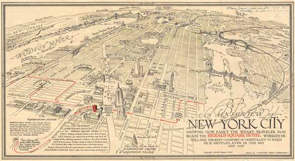
An Aeril View of New York City Showing How Easily the Weary Traveler May Reach the Herald Square Hotel Wherein He Will Find the Rest - Comfort - and Hospitality to Which He is Entitled, Even in this Day and Age.
1931 (undated) 9 x 16 in (22.86 x 40.64 cm)
1931 (undated) 9 x 16 in (22.86 x 40.64 cm)
Description
This is a 1931 Richard Edes Harrison pictorial bird's eye view of New York City. Oriented towards the north, the map depicts the city from the Hudson River to Queens and from Westchester County to Thirtieth Street. Wonderfully illustrated with numerous buildings drawn in profile, the Empire State Building, Macy's the Metropolitan Opera House, and the Chrysler Building take center stage, along with the Herald Square Hotel, which is shaded in red. Both the Pennsylvania Station (commonly referred to as Penn Station) and the Grand Central Terminal are present, along with Madison Square Garden (then located between Eighth and Ninth Avenue not far from Times Square), Carnegie Hall, and Rockefeller Center, which is only roughly shown, as it was still under construction. Central Park is beautifully illustrated and Columbus Circle, the American Museum of Natural History, and the Metropolitan Museum encircle the park. The Queensboro Bridge, the Tri-Borough Bridge, and the George Washington Bridge are illustrated in detail. Outside Manhattan, Astoria and Long Island City are labeled in Queens, and Yankee Stadium is illustrated in profile in the Bronx. The Boston Post Road is drawn and labeled as well.
This map was drawn by Richard Edes Harrison and published in 1931.
This map was drawn by Richard Edes Harrison and published in 1931.
Cartographer
Richard Edes Harrison (1902 - January 5, 1994) was an American cartographer and cartoonist active in the middle part of the 20th century. Harrison is credited with redefining cartography, especially journalistic cartography, by employing spherical perspective, bold shading, and graphic design to both make maps more publicly accessible and give them an artistic dimension. Harrison was born in Baltimore and studied design at Yale, graduating in 1923, before relocating to New York City at the height of the Great Depression. He made ends meet through industrial design work, creating everything from bottles to ashtrays. His first foray into the cartographic world was a fill-in job at Fortune magazine. The editors at Fortune must have admired his work for it launched a long-standing collaboration. His work, doubtless inspired by the age of air travel, became exceptionally popular during World War II, where his unique approach and political charged subject matter illustrated the seats of war with exceptional poignancy and clarity. After the war, Harrison continued to produce maps from his base in New York City. In his spare time he was an avid ornithologist and was commonly seen in Central Park in search of rare bird sightings. More by this mapmaker...
Condition
Very good. Even overall toning. Closed tear extending one inch into printed area from right margin professionally repaired on verso.Manuscript inscription in upper right corner. Text and illustration on verso.
References
Cornell University, Persuasive Maps: PJ Mode Collection, 2270.01. OCLC 45751129.