This item has been sold, but you can get on the Waitlist to be notified if another example becomes available, or purchase a digital scan.
1878 Bien and Johnson Map of New York City (Manhattan Island) During the Revolutionary War
NewYorkCity-johnsonbien-1878$175.00

Title
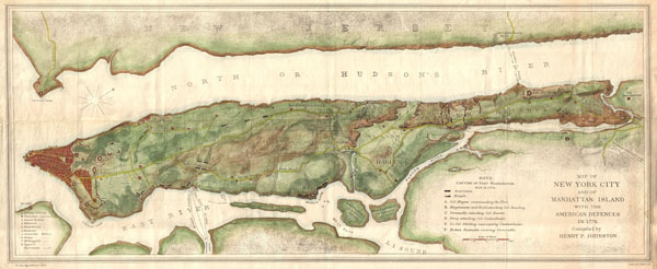
Map of New York City and of Manhattan Island with the American Defences in 1776.
1878 (undated) 14.5 x 35 in (36.83 x 88.9 cm)
1878 (undated) 14.5 x 35 in (36.83 x 88.9 cm)
Description
An unusual map of Manhattan Island will adjacent parts of Long Island and New Jersey drawn in 1878 for issue in Henry P. Johnson's history of the Battle of Long Island. In compiling his history Johnson was frustrated by the lack of a Revolutionary War period map detailing the entire Island of Manhattan. He thus compiled this map which he published with Julius Bien and incorporated into his book. Though quite late compared to colonial period information it presents, this map is significant in that it is possibly the first map to show the whole of Manhattan Island during the Revolutionary War. Cartographically it is based upon the work of Ratzer and Montressor with regard to the southern part of the Island as far north as 50th street. North of 50th street in incorporates data from the Commissioners plan of 1811 and from Sauthier's map of New York. Beyond the developed southern portions of the city that extend north only as far as modern day Canal Street the city is laid out topographically, with hills, river courses, and plains apparent. Bloomingdale Road (modern day Broadway) is identified as is the Kings Bridge or Post Road. Shows various fortifications throughout as well as military notations regarding the placement of British and American troops. Though fiercely fought the British ultimately won the Battle of Long Island and the Battle of Harlem Heights, thus seizing control of New York City, which they maintained until the end of the Revolutionary War.
Cartographer
Julius (Julien) Bien (September 27, 1826 - December 21, 1909) was a German-Jewish lithographer and engraver based in New York City. Bien was born in Naumburg, Germany. He was educated at the Academy of Fine Arts, Cassell and at Städel's Institute, Frankfurt-am-Main. Following the suppression of the anti-autocratic German Revolutions of 1848, Bien, who participated in the pan-German movement, found himself out of favor in his home country and joined the mass German immigration to the United States. Bien can be found in New York as early as 1849. He established the New York Lithographing, Engraving & Printing Company in New York that focused on the emergent chromo-lithograph process - a method of printing color using lithographic plates. His work drew the attention of the U.S. Government Printing Office which contracted him to produce countless government maps and surveys, including the Pacific Railroad Surveys, the census, numerous coast surveys, and various maps relating to the American Civil War. Bien also issued several atlases both privately and in conjunction with a relation, Joseph Bien. At the height of his career Bien was elected president of the American Lithographers Association. After his death in 1909, Bien's firm was taken over by his son who promptly ran it into insolvency. The firm was sold to Sheldon Franklin, who, as part of the deal, retained the right to publish under the Julius Bien imprint. In addition to his work as a printer, Bien was active in the New York German Jewish community. He was director of the New York Hebrew Technical Institute, the New York Hebrew Orphan Asylum, and president of the B'nai B'rith Order. More by this mapmaker...
Source
Johnson, H. P., The Campaign of 1776 around New York and Brooklyn.
Condition
Very good. Backed with linen by a previous owner.