This item has been sold, but you can get on the Waitlist to be notified if another example becomes available, or purchase a digital scan.
1860 Mitchell Map of New York City, New York (first edition)
NewYorkCity-mitchell-1860$125.00

Title
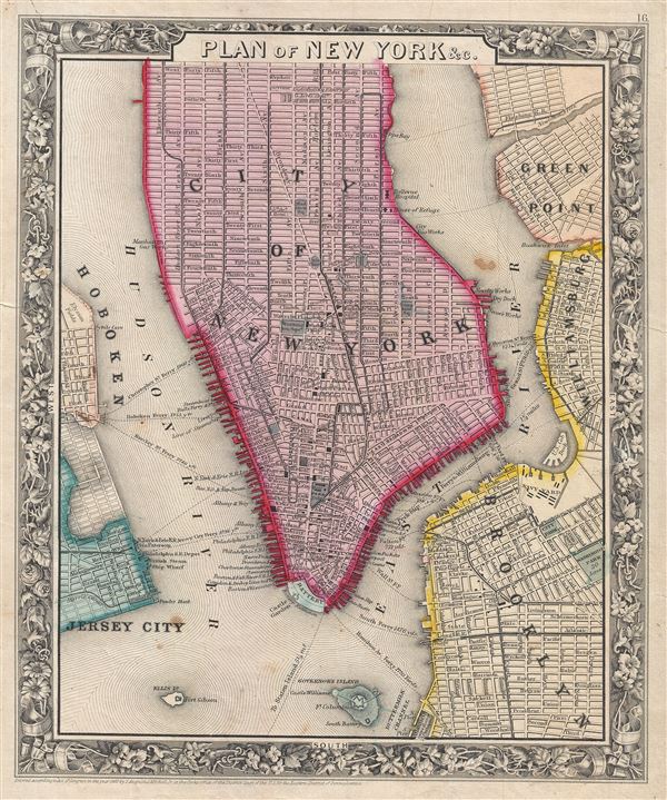
Plan of New York & c.
1860 (dated) 13 x 11 in (33.02 x 27.94 cm)
1860 (dated) 13 x 11 in (33.02 x 27.94 cm)
Description
A beautiful example of the first edition of S. A. Mitchell's 1860 map of New York City. The map depicts southern Manhattan, below 45th street, along with parts of Brooklyn, Williamsburg, Greenpoint, Hoboken, and Jersey City. Mitchell offers wonderful detail at the street level including references to parks, individual streets, piers, ferries, and important buildings. Colored coded with red, green, and yellow pastels according to political divisions. The whole is surrounded by the attractive floral border common to Mitchell atlases between 1860 and 1865. This variant differs from later examples (1861-2) of Mitchell's New York in that city wards are not defined. One of the more attractive atlas maps of New York to appear in the mid-19th century. Prepared by S. A. Mitchell Jr. for inclusion as plate 16 in the 1860 issue of Mitchell's New General Atlas. Dated and copyrighted, 'Entered according to Act of Congress in the Year 1860 by S. Augustus Mitchell Jr. in the Clerk's Office of the District Court of the U.S. for the Eastern District of Pennsylvania.'
Cartographer
Samuel Augustus Mitchell (March 20, 1792 - December 20, 1868) began his map publishing career in the early 1830s. Mitchell was born in Bristol, Connecticut. He relocated to Philadelphia in 1821. Having worked as a school teacher and a geographical writer, Mitchell was frustrated with the low quality and inaccuracy of school texts of the period. His first maps were an attempt to rectify this problem. In the next 20 years Mitchell would become the most prominent American map publisher of the mid-19th century. Mitchell worked with prominent engravers J. H. Young, H. S. Tanner, and H. N. Burroughs before attaining the full copyright on his maps in 1847. In 1849 Mitchell either partnered with or sold his plates to Thomas, Cowperthwait and Company who continued to publish the Mitchell's Universal Atlas. By about 1856 most of the Mitchell plates and copyrights were acquired by Charles Desilver who continued to publish the maps, many with modified borders and color schemes, until Mitchell's son, Samuel Augustus Mitchell Junior, entered the picture. In 1859, S.A. Mitchell Jr. purchased most of the plates back from Desilver and introduced his own floral motif border. From 1860 on, he published his own editions of the New General Atlas. The younger Mitchell became as prominent as his father, publishing maps and atlases until 1887, when most of the copyrights were again sold and the Mitchell firm closed its doors for the final time. More by this mapmaker...
Source
Mitchell Jr., S. A., Mitchell's New General Atlas, Containing Maps Of The Various Countries Of The World, Plans Of Cities, Etc. Embraced In Forty-Seven Quarto Maps, Forming A Series Of Seventy-Six Maps And Plans, Together With Valuable Statistical Tables. (1860 First Edition)
Condition
Very good condition. Blank on verso.
References
Rumsey 0565.010. Phillips (Atlases) 831-16. New York Public Library, Map Division, Digital ID: 1510801. Haskell, Manhattan Maps: A Co-operative List, 1104 & 1105.