This item has been sold, but you can get on the Waitlist to be notified if another example becomes available, or purchase a digital scan.
1933 Nostrand Map and Hotel Guide of New York City
NewYorkCity-nostrand-1933$225.00


Title
Nostrands Map of New York House Numbers Subway Guide / Visitors Map and Hotel Directory of New York.
1933 (undated) 30.75 x 20 in (78.105 x 50.8 cm) 1 : 17500
1933 (undated) 30.75 x 20 in (78.105 x 50.8 cm) 1 : 17500
Description
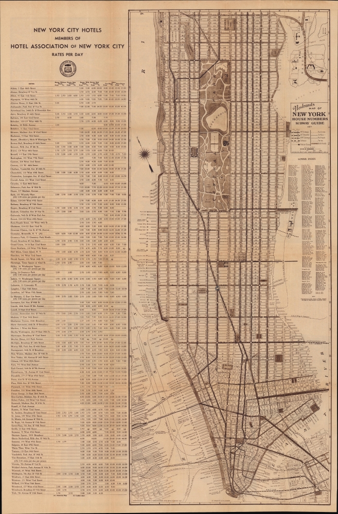
An eminently useful map and guide, this work was produced c. 1933 by George Nostrand of the Ohman Map Co. for the Hotel Association of New York City. It presents the city during the strange decade of the 1930s, when economic depression gripped the country but also when many of the city's distinctive buildings, bridges, and tunnels were built.
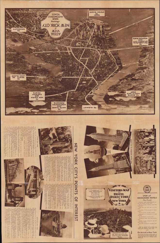
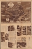
The verso is equally rich in information and images. On one half, a bird's eye aerial view (by Fairchild Aerial Surveys, Inc.) taken from the harbor to the south of the city looks northwards, with major connections in and out of the city indicated. Multiple photographs appear of major landmarks in the city, including the recently-built skyscrapers of Rockefeller Center, the Chrysler Building, and the Empire State Building, with the title panel displaying a view from the latter looking southwards towards downtown Manhattan and Brooklyn. A list is provided of major points of interest in different parts of the city.
A Closer Look
Covering Manhattan south of 125th St. along with portions of Brooklyn and New Jersey, this map notes streets, subway lines, elevated streetcar lines, bridges, tunnels, ferry lines, and piers. Prominent public buildings such as museums, train stations, government offices, and parks are also labelled. An alphanumeric grid surrounds the map, corresponding to a street index at right. At left, a list of hotels belonging to the Hotel Association of New York City appears, listing their nightly rates for various types of rooms (the city's poshest accommodations are included, such as the Astor, Ambassador, and Plaza Hotels).The verso is equally rich in information and images. On one half, a bird's eye aerial view (by Fairchild Aerial Surveys, Inc.) taken from the harbor to the south of the city looks northwards, with major connections in and out of the city indicated. Multiple photographs appear of major landmarks in the city, including the recently-built skyscrapers of Rockefeller Center, the Chrysler Building, and the Empire State Building, with the title panel displaying a view from the latter looking southwards towards downtown Manhattan and Brooklyn. A list is provided of major points of interest in different parts of the city.
Publication History and Census
This map was prepared by George Nostrand, working for the Ohman Map Co., for the Hotel Association of New York City. It is undated, but from the buildings and infrastructure present must date to 1933 or 1934; the photograph of a completed Rockefeller Center indicates a date of 1933 or later, while the lack of the Lincoln Tunnel would suggest a likely date before 1934 (when construction on the tunnel began) and certainly before 1937 (when the tunnel opened to traffic). The appearance of the Triboro Bridge may suggest a somewhat later date as it opened in 1936, but it had been under construction in some form since 1929, making it an unreliable guide for dating. Due to uncertainty over the date and title, this work looks to have been cataloged multiple times in the OCLC. Altogether, six institutions - Stanford University (Rumsey Historical Map Collection), the University of Michigan, the New York Public Library, the University of Wisconsin-Milwaukee, the University of Chicago, and Michigan State University - catalog maps with this title, with proposed dates between 1930 and 1939.CartographerS
George J. Nostrand (fl. 1920-30) was an American lithographer and publisher of maps and views, primarily of New York City. He appears to have been in the employ of the Arthur Ohman Map Co. until the firm’s closing in 1925. Thereafter he operated from the same location under his own name as late as 1939. More by this mapmaker...
August Reinhold Ohman (May 3, 1859 - April 22, 1934) was a Swedish-American map publisher, engraver, and draftsman. Ohman arrived in the United States in 1893. He married Alice Mary Colton (1868 - 193x), Charles B. Colton's daughter, on January 5, 1897. A year later, in 1898, Ohman began working with G.W. and C.B. Colton, when the firm became known as Colton, Ohman, and Company, which existed until about 1901. After that year, Ohman operated his own firm under his own name August R. Ohman, and advertised his firm as the 'successors to the Coltons'. The Ohman Map Company, as it became known, moved to 258 Broadway around 1914, where it operated until around 1925. George J. Nostrand, who became a major map publisher, operated in the same buiding and possibly even worked for Ohman. Some of Nostrand's work is very similar to Ohman's, particularly his bird's eye view of New York City. Learn More...
Sherman Mills Fairchild (April 7, 1896 – March 28, 1971) was an American inventor, entrepreneur, pilot, and photographer active in New York in the first half of the 20th century. He was the son of George Winthrop Fairchild, a Republican Congressman and Co-Founder of IBM. He inherited his father's vast estate in 1924, becoming IBM's largest shareholder. After studying at Harvard, the University of Arizona, and Columbia University, Fairchild invented the synchronized camera shutter and flash – a significant advancement in photography. Sherman was chronically in poor health, nonetheless, when World War I broke out he volunteered for the military. Due to his health, he was rejected by the military, so he decided to contribute to the war effort in another way. He took a contract with the U.S. Government to develop a new kind of aerial camera capable of taking sequentially timed photographs for advanced aerial terrain mapping. This invention led to the founding of the Fairchild Aerial Camera Corporation (later the Fairchild Camera and Instrument Company) in 1920. In 1921, he purchased a surplus World War I Fokker D. VII biplane and expanded with his own aerial survey company, Fairchild Aerial Surveys. His first map, the first aerial photo-survey of a major city, was of Newark, New Jersey. This was quickly followed by a large aerial survey of Manhattan, also completed in 1921. Other cities followed. Later the Fairchild Corporation developed even more advanced cameras, including the Fairchild Lunar Mapping Camera, used by NASA to take photos of the Moon from orbit. He also founded Fairchild Aviation Corporation, which built the FC-1 and FC-2 Aircraft. The firm went on to become one of the largest military and defense contractors in the world. Fairchild died in 1971, leaving behind a $200+ million dollar estate to varies charities and foundations. Learn More...
Condition
Good. Wear along original fold lines. Verso repairs to fold separations and at fold intersections. Slight loss at a few fold intersections. Text and printed images on verso.
References
Rumsey 8551.003. OCLC 1052567327, 774397105, 953572583.