This item has been sold, but you can get on the Waitlist to be notified if another example becomes available, or purchase a digital scan.
1845 Humphrey Phelps Map of New York City (Manhattan and Brooklyn)
NewYorkCity-phelps-1845$500.00

Title
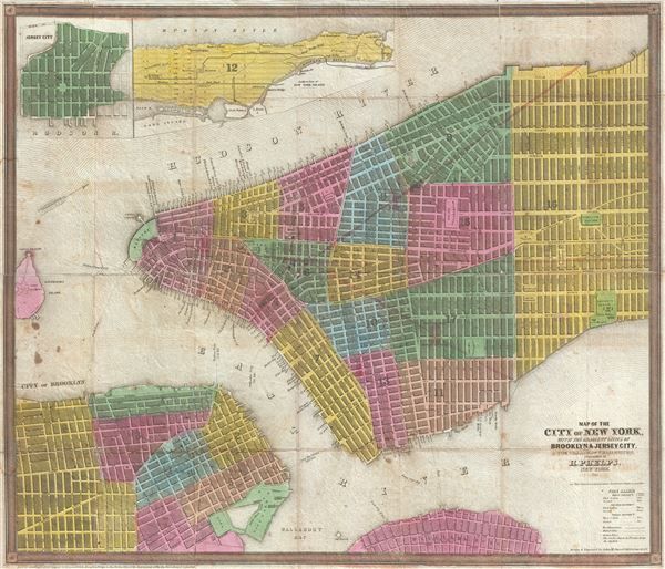
Map of the City of New York, with the adjacent Cities of Brooklyn & Jersey City, and the Village of Williamsburg.
1845 (dated) 17.25 x 20.25 in (43.815 x 51.435 cm) 1 : 10500
1845 (dated) 17.25 x 20.25 in (43.815 x 51.435 cm) 1 : 10500
Description
This scarce 1845 map of New York City and adjacent parts of Brooklyn was published by Humphrey Phelps. Oriented to the west, this map covers the lower parts of Manhattan from the Battery to 32nd Street. It additionally covers adjacent parts of Brooklyn from the East River to Nevins Street and South as far as Sackett Street. Williamsburg peeks out from the bottom of the map and is covered from south 11th Street to North 13th Street and from the waterfront to Third Avenue. An inset in the upper left quadrant details the upper portions of Manhattan, including the growing communities of Harlem, Yorkville, Bloomingdale, and Manhattanville. Croton Aqueduct is noted. A second inset details Jersey City. Governors Island, with Fort Columbus and Castle Williams, is noted. The whole is color coded by city ward. A table in the lower right quadrant elaborates upon the city's fire alarm system.
This map was published by Humphrey Phelps and is one of the few maps that Phelps produced without a partner. The engraving was contracted to John M. Atwood of 145 Fulton Street, a very active New York engraver who worked with most major map publishers of the period. The copyright is registered to Phelps in the year 1844, but no examples from this edition, if it exists, are known. This present edition, 1845, appears in only two collections, the New York Public Library, and the New York Historical Society. A scare and exceptional find. Later editions are known from 1848, 1849, 1850, and 1852 when Phelps partnered with Ensign.
This map was published by Humphrey Phelps and is one of the few maps that Phelps produced without a partner. The engraving was contracted to John M. Atwood of 145 Fulton Street, a very active New York engraver who worked with most major map publishers of the period. The copyright is registered to Phelps in the year 1844, but no examples from this edition, if it exists, are known. This present edition, 1845, appears in only two collections, the New York Public Library, and the New York Historical Society. A scare and exceptional find. Later editions are known from 1848, 1849, 1850, and 1852 when Phelps partnered with Ensign.
CartographerS
Humphrey Phelps (1799 - 1875) was an American map, broadside, and book publisher based in New York City. Phelps was born in 1799 in Hebron, Connecticut. Phelps' earliest work seems to be a plan of New York City for his Stranger's Guide, dating to about 1830. Between 183- and 1837 he published with Bela Scovil Squire (1786 - 1861) under the imprint of Phelps and Squire. The New York map publishing circle seems to have been quite close and Phelps commonly partnered with various other New York publishers and printers including Edward H. Ensign (1818 - 1871), Horace Thayer, Erastus Clark Bridgman (1817 - 1870), Thomas C. Fanning (1805 - 1873), Hooker, Peabody, Charles Magnus, Gaylord Watson, and George Walker, among others. The natural consequence of his rampant partnering is a vast and varied corpus of work including many scarce items with low print runs. Phelps is best known for his emigrant and tourist guides. More by this mapmaker...
John M. Atwood (1817 - October 12, 1884) was an American engraver based in Philadelphia and New York City during the middle part of the 19th century. Atwood was born in Georgetown, near Washington D.C. Little is known of Atwood's life but most of his work was completed in conjunction with the publishing firms of Horace Thayer and J. H. Colton. A review of Atwood's work suggests that he was a highly accomplished, stylistically distinct, and detail oriented engraver. Colton seems to have turned to Atwood to engrave some of his most important as well as decorative maps. His most influential map is most likely the 1856 De Cordova pocket map of Texas, however, he also engraved the Colton's well known and highly decorative Thirty Three Miles Around New York and Colton's important 1849 Map of the United States. Learn More...
Condition
Good. Backed on archival tissue. Minor wear to original fold lines. Light soiling.
References
Haskell, D., Manhattan Maps A Co-operative List, 872. New York Public Library, Map Division, Map Div. 01-1801.