
This item below is out of stock, but another example (left) is available. To view the available item, click "Details."
Details
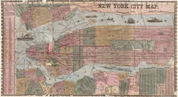
1857 Phelps City Map or Plan of New York City
1857 (dated) $1,500.00
1857 Phelps Map of New York City
NewYorkCity-phelps-1857$125.00

Title
New York City Map.
1857 (dated) 15.5 x 29 in (39.37 x 73.66 cm)
1857 (dated) 15.5 x 29 in (39.37 x 73.66 cm)
Description
An uncommon and colorful 1857 map of New York City by Humphrey Phelps. The map covers Manhattan south of 131st street as well as adjacent parts of Brooklyn, Queens, Hoboken, and Jersey City. Individual streets are named as are many individual buildings. The map notes various fery crossing, names piers, and shows shipping lanes. Various types of sailing, cargo, and stem vessels decorate the Hudson River. Where Columbia University now stands, this map reveals a 19th century Lunatic Asylum. Central Park, though only in the planning stages when this map was published, is rendered detail exhibiting the fully glory of Olmsted's plan.
The mid-19th century was a dynamic period in urban development of New York City. Under the governance of Tammany Hall and the corrupt 'Boss' Tweed, New York City had become a melange of extremes. By 1864 the Five Points had devolved into the world's most notoriously dangers slum, while further north the high ideals and design genius of Frederick Law Olmsted and Calvert Vaux created Central Park, the world's first and possibly finest planned public recreation area. Meanwhile, across the east River, Brooklyn, Greenpoint, and Williamsburg consolidated into a single city, becoming in the process the third largest city in the United States, and setting the stage for the emergence of the modern New York City.
Prepared for issue in Humphrey Phelps' Strangers and Citizens' Guide to New York City. This map has condition issues, please note the condition statement below.
Cartographer
Humphrey Phelps (1799 - 1875) was an American map, broadside, and book publisher based in New York City. Phelps was born in 1799 in Hebron, Connecticut. Phelps' earliest work seems to be a plan of New York City for his Stranger's Guide, dating to about 1830. Between 183- and 1837 he published with Bela Scovil Squire (1786 - 1861) under the imprint of Phelps and Squire. The New York map publishing circle seems to have been quite close and Phelps commonly partnered with various other New York publishers and printers including Edward H. Ensign (1818 - 1871), Horace Thayer, Erastus Clark Bridgman (1817 - 1870), Thomas C. Fanning (1805 - 1873), Hooker, Peabody, Charles Magnus, Gaylord Watson, and George Walker, among others. The natural consequence of his rampant partnering is a vast and varied corpus of work including many scarce items with low print runs. Phelps is best known for his emigrant and tourist guides. More by this mapmaker...
Source
Phelps, H., Strangers and Citizens' Guide to New York City, (New York) 1857.
Condition
Average. This map has been professionally restored with added margins on all sides. There are significant fill repairs in lower manhattan - see image. Price adjusted accordingly.
References
Haskell, D., Manhattan Maps: A Co-operative List, 1045.