This item has been sold, but you can get on the Waitlist to be notified if another example becomes available, or purchase a digital scan.
1910 U.S. Coast Survey Nautical Chart or Map of New York City and Harbor
NewYorkCity-uscs-1910$475.00

Title
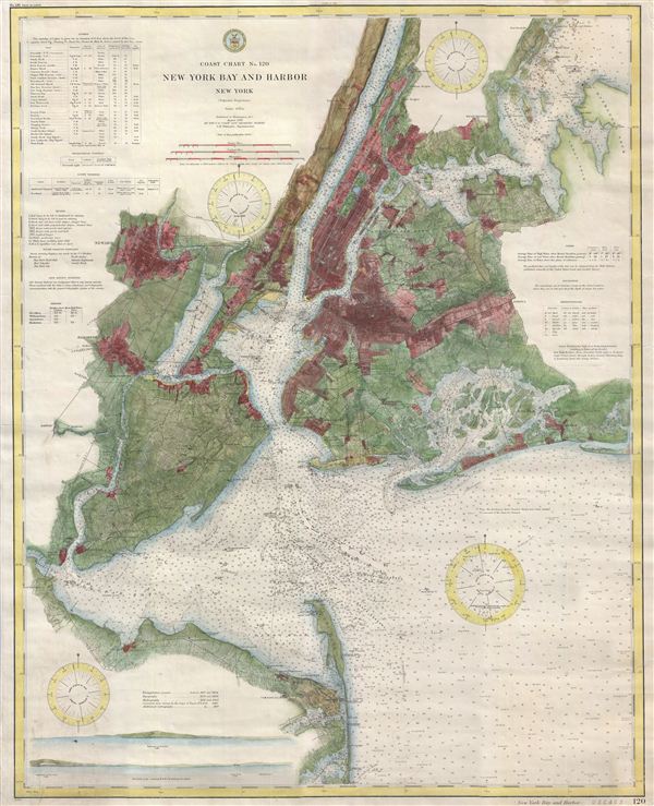
Coast Chart No. 120, New York Bay and Harbor, New York.
1910 (dated) 31 x 27 in (78.74 x 68.58 cm)
1910 (dated) 31 x 27 in (78.74 x 68.58 cm)
Description
This magnificent map is rare 1910 reissue of the 1866 U. S. Coast Survey chart of New York City, its harbor, and environs. The 1866 U. S. C. S. chart represents the culmination of the Coast Survey's work in the New York City areas. It was, consequently, one of the first 19th century carts to depict New York City as we know it today, including Manhattan, Queens, Brooklyn, the Bronx and Staten Island. The map also includes the adjacent Jersey City, Newark and Hoboken. This reissue updates the 1866 chart to reflect minor changes through 1910 and offers additional detail throughout, including several shore profiles in the lower left quadrant. In addition to inland details, this chart contains a wealth of practical information for the mariner from oceanic depths, to harbors and navigation tips on important channels. Map also includes tables of light houses and beacons, tides and magnetic declination as well as detailed sailing instructions. It is of note that this is not one of the delicate charts issued with the annual Superintendent's Reports, but is rather a high quality independent issue on thick paper and backed with linen.
The triangulation for this chart was prepared by J. Ferguson and E. Blunt. The topography by H. L. Whiting, S. A. Gilbert, A. M Harrison, F. W. Door, C. Rockwell and J. M E. Chan. The hydrography was accomplished by R. Wainwright and T. A. Craven. The entire 1866 production was supervised by A. D. Bache, Superintendent of the Survey of the Coast of the United States and one of the most influential American cartographers of the 19th century. This 1910 reissue was printed at the orders of O. H. TIttmann, Superintendent of the U.S. Coast and Geodetic Survey.
The triangulation for this chart was prepared by J. Ferguson and E. Blunt. The topography by H. L. Whiting, S. A. Gilbert, A. M Harrison, F. W. Door, C. Rockwell and J. M E. Chan. The hydrography was accomplished by R. Wainwright and T. A. Craven. The entire 1866 production was supervised by A. D. Bache, Superintendent of the Survey of the Coast of the United States and one of the most influential American cartographers of the 19th century. This 1910 reissue was printed at the orders of O. H. TIttmann, Superintendent of the U.S. Coast and Geodetic Survey.
Cartographer
The Office of the Coast Survey (1807 - present) founded in 1807 by President Thomas Jefferson and Secretary of Commerce Albert Gallatin, is the oldest scientific organization in the U.S. Federal Government. Jefferson created the "Survey of the Coast," as it was then called, in response to a need for accurate navigational charts of the new nation's coasts and harbors. The spirit of the Coast Survey was defined by its first two superintendents. The first superintendent of the Coast Survey was Swiss immigrant and West Point mathematics professor Ferdinand Hassler. Under the direction of Hassler, from 1816 to 1843, the ideological and scientific foundations for the Coast Survey were established. These included using the most advanced techniques and most sophisticated equipment as well as an unstinting attention to detail. Hassler devised a labor intensive triangulation system whereby the entire coast was divided into a series of enormous triangles. These were in turn subdivided into smaller triangulation units that were then individually surveyed. Employing this exacting technique on such a massive scale had never before been attempted. Consequently, Hassler and the Coast Survey under him developed a reputation for uncompromising dedication to the principles of accuracy and excellence. Unfortunately, despite being a masterful surveyor, Hassler was abrasive and politically unpopular, twice losing congressional funding for the Coast Survey. Nonetheless, Hassler led the Coast Survey until his death in 1843, at which time Alexander Dallas Bache, a great-grandson of Benjamin Franklin, took the helm. Bache was fully dedicated to the principles established by Hassler, but proved more politically astute and successfully lobbied Congress to liberally fund the endeavor. Under the leadership of A. D. Bache, the Coast Survey completed its most important work. Moreover, during his long tenure with the Coast Survey, from 1843 to 1865, Bache was a steadfast advocate of American science and navigation and in fact founded the American Academy of Sciences. Bache was succeeded by Benjamin Pierce who ran the Survey from 1867 to 1874. Pierce was in turn succeeded by Carlile Pollock Patterson who was Superintendent from 1874 to 1881. In 1878, under Patterson's superintendence, the U.S. Coast Survey was reorganized as the U.S. Coast and Geodetic Survey (C & GS) to accommodate topographic as well as nautical surveys. Today the Coast Survey is part of the National Oceanic and Atmospheric Administration or NOAA as the National Geodetic Survey. More by this mapmaker...
Condition
Very good condition. Issued on thick paper and backed with linen.
References
Rumsey 5328.000 (1866 edition), 1234.115 (1877 edition); Phillips, 2141; LeGear Atlases of the United States, L2307; Phillips, Philip Lee. A List of Maps of America in the Library of Congress, p. 492.