This item has been sold, but you can get on the Waitlist to be notified if another example becomes available, or purchase a digital scan.
1854 Mitchell Map of New York City
NewYorkCity2-mitchell-1854$125.00

Title
City of New York.
1850 (dated) 16 x 13 in (40.64 x 33.02 cm) 1 : 65000
1850 (dated) 16 x 13 in (40.64 x 33.02 cm) 1 : 65000
Description
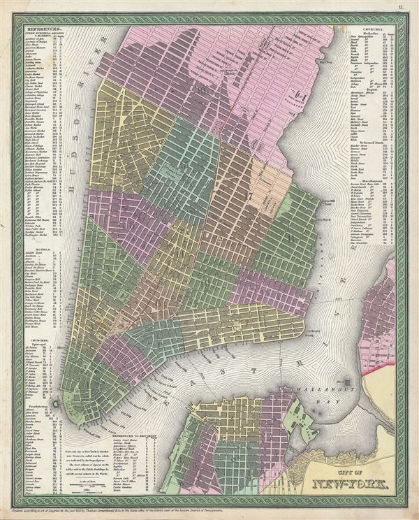
This is a beautiful example of S. A. Mitchell Junior's 1846 map of New York City. The map depicts southern Manhattan from 37th street (Kips Bay) south to Battery Park and Brooklyn from Williamsburg to Columbia St. Mitchell offers wonderful detail at the street level including references to parks, individual streets, piers, ferries, and important buildings. Color coded with red, green, and yellow pastels according to political divisions. An index of Churches, hotels, markets, squares, public buildings etc. is included along the left and right borders. The whole is engraved and colored in Mitchell's distinctive style with green border work and vivid pastels.
One of the more attractive atlas maps of New York to appear in the mid-19th century.
This map was prepared by S. A. Mitchell for publication as plate no. 11 in the 1854 edition of Mitchell's New General Atlas. Dated and copyrighted, 'Entered according to act of Congress in the year 1850 by Thomas Cowperthwait and Co. in the Clerk's office of the Eastern District of Pennsylvania.'
Cartographer
Samuel Augustus Mitchell (March 20, 1792 - December 20, 1868) began his map publishing career in the early 1830s. Mitchell was born in Bristol, Connecticut. He relocated to Philadelphia in 1821. Having worked as a school teacher and a geographical writer, Mitchell was frustrated with the low quality and inaccuracy of school texts of the period. His first maps were an attempt to rectify this problem. In the next 20 years Mitchell would become the most prominent American map publisher of the mid-19th century. Mitchell worked with prominent engravers J. H. Young, H. S. Tanner, and H. N. Burroughs before attaining the full copyright on his maps in 1847. In 1849 Mitchell either partnered with or sold his plates to Thomas, Cowperthwait and Company who continued to publish the Mitchell's Universal Atlas. By about 1856 most of the Mitchell plates and copyrights were acquired by Charles Desilver who continued to publish the maps, many with modified borders and color schemes, until Mitchell's son, Samuel Augustus Mitchell Junior, entered the picture. In 1859, S.A. Mitchell Jr. purchased most of the plates back from Desilver and introduced his own floral motif border. From 1860 on, he published his own editions of the New General Atlas. The younger Mitchell became as prominent as his father, publishing maps and atlases until 1887, when most of the copyrights were again sold and the Mitchell firm closed its doors for the final time. More by this mapmaker...
Source
Mitchell, S. A., A New Universal Atlas Containing Maps of the various Empires, Kingdoms, States and Republics Of The World, (Thomas Cowperthwait & Co., Philadelphia) 1854.
Condition
Very good. Overall age toning. Minor spotting at places. Minor repair in top left quadrant.
References
Rumsey 0537.012 (1846 edition). Phillips (Atlases) 6103-11. Haskell, D. C., Manhattan Maps: A Co-operative List, 901.