
This item below is out of stock, but another example (left) is available. To view the available item, click "Details."
Details
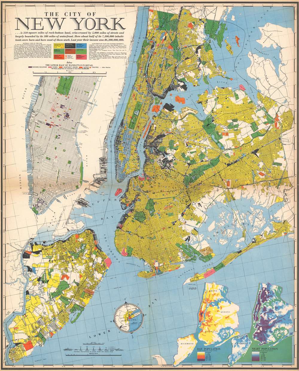
1939 Richard Edes Harrison Map of New York City
$500.00
1939 Richard Edes Harrison Map of New York City
NewYorkCity4-harrison-1939$275.00

Title
The City of New York.
1939 (dated) 27.5 x 22 in (69.85 x 55.88 cm) 1 : 76000
1939 (dated) 27.5 x 22 in (69.85 x 55.88 cm) 1 : 76000
Description
This 1939 Richard Edes Harrison map of New York City - published in conjunction with the New York World’s Fair – represents a triumph of the visual display of quantitative information. Its aesthetic impact is all the more impressive in its clear expression of municipal and demographic data, making this a map of the people of New York City, as much as of the physical city itself. All five boroughs are represented in the primary map. On it, Harrison’s masterful use of vivid color to distinguish between residential, commercial, industrial, and federal use of land is clear yet supple, able to make distinction (for example) of low-income housing projects using the same palette. Parks and cemeteries both appear as green spaces, with white spots - evoking headstones - indicating the difference between the two. The two major airports (Floyd Bennett Field and North Beach Airport) are given their own color as well. The city’s industrial areas, shown in black, dominate the East River and Hudson coastlines, a reminder of the centrality of trade to the city’s development and history.
In an old-world touch, the map sports a very elegant compass rose. But even this is packed full of useful detail: within its circuit is yet another inset map, showing the ‘limit of the main map’ in the context of the greater metropolitan area and the surrounding states.
The Lower Half of Manhattan in Detail
Underneath the map’s title, a detail of Manhattan from the middle of Central Park to The Battery allows for the presentation, in finer detail, of New York’s finer life: Using a new color code, Harrison marks the city’s most valuable real estate (structures assessed at 5 million dollars or more!) These include business buildings, stores, apartment houses, theatres… and ‘other theatres.’ (The precise nature of that last distinction is not made clear.)Day And Night
Though smaller and perhaps more abstract, the detail in the lower right-hand corner of the map matches the rest of it in fascination: a dual map of all five boroughs in miniature, using bright and dark palettes to show the changing population density of the city by day and by night. Never was the diurnal chaos of the New York City commute presented so cleanly.In an old-world touch, the map sports a very elegant compass rose. But even this is packed full of useful detail: within its circuit is yet another inset map, showing the ‘limit of the main map’ in the context of the greater metropolitan area and the surrounding states.
Publication History and Census
This map appeared in only one edition, as a supplement to the July issue of Fortune Magazine. OCLC lists five examples in institutional collections.Cartographer
Richard Edes Harrison (1902 - January 5, 1994) was an American cartographer and cartoonist active in the middle part of the 20th century. Harrison is credited with redefining cartography, especially journalistic cartography, by employing spherical perspective, bold shading, and graphic design to both make maps more publicly accessible and give them an artistic dimension. Harrison was born in Baltimore and studied design at Yale, graduating in 1923, before relocating to New York City at the height of the Great Depression. He made ends meet through industrial design work, creating everything from bottles to ashtrays. His first foray into the cartographic world was a fill-in job at Fortune magazine. The editors at Fortune must have admired his work for it launched a long-standing collaboration. His work, doubtless inspired by the age of air travel, became exceptionally popular during World War II, where his unique approach and political charged subject matter illustrated the seats of war with exceptional poignancy and clarity. After the war, Harrison continued to produce maps from his base in New York City. In his spare time he was an avid ornithologist and was commonly seen in Central Park in search of rare bird sightings. More by this mapmaker...
Condition
Very good condition. Color lithograph. Lightly toned at fold, mend to juncture of folds with no loss.
References
Rumsey 11077.000. OCLC 35173087.