
This item below is out of stock, but another example (left) is available. To view the available item, click "Details."
Details
1863 Johnson City Plan or Map of New York City and Brooklyn
1863 (undated) $350.00
1865 Johnson Map of New York City and Brooklyn
NewYorkCity4-johnson-1865$150.00

Title
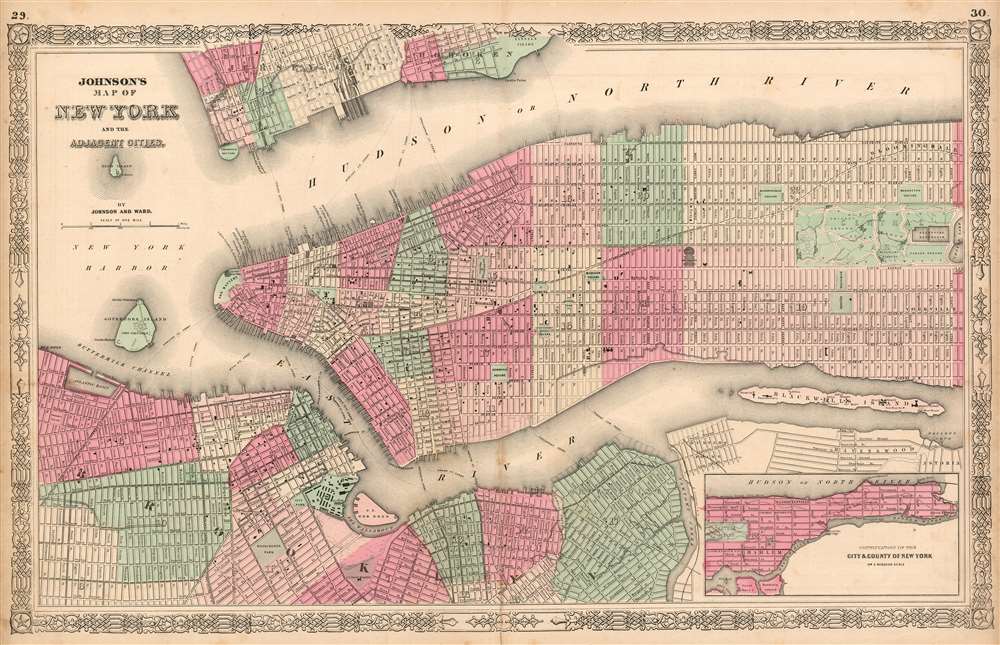
Johnson's Map of New York and the Adjacent Cities.
1865 (undated) 16 x 26 in (40.64 x 66.04 cm) 1 : 20000
1865 (undated) 16 x 26 in (40.64 x 66.04 cm) 1 : 20000
Description
This is Johnson and Ward's 1865 map of New York City. This lithograph map covers the island of Manhattan and the borough of Brooklyn as well as parts of Jersey City and Hoboken. The map reaches as far north as Eighty eighth street in Manhattan; an inset in the lower right shows the remainder of the island 'on a reduced scale.' The city's wards are numbered, and distinguished from each other with hand color. The map shows the city's grid in detail, including areas of planned landfill in both Manhattan and Brooklyn. The Hudson and the East River are spanned by ferries, which are marked and named. With the exception of the newly built Long Island Railroad (its Hunter's Point terminus is visible) no railways yet appear in New York. A burgeoning terminal can be seen in Jersey City, however.
New York's Parks Multiply
The map highlights many of the city's green spaces, which were a sharply-needed antidote to the city's boom in population density that began with the opening of the Erie Canal. City Hall Park, Tompkins Square, Washington Square, Union Square, Stuyvesant, Manhattan and Madison Square are all shown. Hamilton Square, long a neighborhood in the vicinity of Park Avenue and 66th Street, is shown. By the time this map was produced, however, the plot had been subdivided and sold in the wake of the recent creation of Central Park. The map also includes Bloomingdale Square, from 53rd to 57th Streets between Eighth and Ninth Avenues. Though this was included in the 1811 Commissioners' plan and appeared on many maps, it was actually never executed and was struck from the plan in 1857, also in deference to the newly-created Central Park only two blocks north of it. Central Park itself is shown in great detail in its earlier incarnation, with the receiving Reservoir in the place of today’s Great Lawn. In Brooklyn, Washington Park (Now Fort Greene Park) can be seen. Prospect Park was not yet proposed, and in any case would eventually appear outside the bounds of the present map.Municipal and Government Buildings
Throughout the map can be seen hospitals, fortifications and batteries; the Brooklyn Navy Yard is shown in detail. New York's long standing effort to keep its unfortunates at arm's length is evident in the details of Blackwell's Island. Later known as Welfare Island (and now known as Roosevelt Island,) it is shown to be home to a hospital, a penitentiary, men's and women's alms houses, and a work house. A large lunatic asylum neighbors both the 'New mad house' and the 'old mad house.'Publication History and Census
This map appeared in the 1865 Johnson and Ward edition of Johnson’s Family Atlas. This was the last edition of this map to bear the Johnson and Ward imprint.Cartographer
Alvin Jewett Johnson (September 23, 1827 - April 22, 1884) was a prolific American map publisher active from 1856 to the mid-1880s. Johnson was born into a poor family in Wallingford, Vermont, where he received only a basic public education. He is known to have worked as a school teacher for several years before moving to Richmond, Virginia. Johnson got his first taste of the map business as a salesman and book canvasser for J. H. Colton. The earliest Johnson maps were published with D. Griffing Johnson (no clear relation) and date to the mid-1850s; however, it was not until 1860 that the Johnson firm published its first significant work, the Johnson's New Illustrated (Steel Plate) Family Atlas. The publication of the Family Atlas followed a somewhat mysterious 1859 deal with the well-established but financially strapped J. H. Colton cartographic publishing firm. Although map historian Water Ristow speculates that Colton sold his copyrights to Johnson and his business partner, another Vermonter named Ross C. Browning (1822 - 1899), a more likely theory is that Johnson and Browning financially supported the Colton firm in exchange for the right to use Colton's existing copyrighted map plates. Regardless of which scenario actually occurred, it is indisputable that the first Johnson atlas maps were essentially reissues of earlier Colton maps. Early on, Johnson described his firm as the 'Successors to J. H. Colton and Company'. Johnson's business strategy involved transferring the original Colton steel plate engravings to cheaper lithographic stones, allowing his firm to produce more maps at a lower price point. In 1861, following the outbreak of the American Civil War (1861 - 1865) Johnson and Browning split their firm between two offices. Johnson moved from Richmond, Virginia, to New York City. Browning remained in Richmond, where he published at least one more edition of the atlas in 1862, at the height of the war. Johnson and Browning published two editions of the Johnson Atlas: 1860 (Richmond and New York) and 1861 (Richmond and New York). Sometime in 1861, Browning's portion of the firm (or perhaps the New York portion?) was purchased by Benjamin P. Ward, whose name subsequently replaced Browning's on the imprint. The 1863 issue of the Family Atlas was one of the most unusual, it being a compilation of older 'Johnson and Browning' maps, updated 1862 'Johnson and Ward' maps, and newer 1863 maps with a revised border design. The 1864 issue of the Family Atlas is the first fully 'Johnson and Ward' atlas. Johnson published one more edition of the atlas in partnership with Ward in 1865, after which Johnson bought out Ward. The next issue of the atlas, 1866, is the first purely 'Johnson' atlas with all new map plates, updated imprints, and copyrights. The Family Atlas went through roughly 27 years of publication, from 1860 to 1887, outliving Johnson himself, who died in 1884. Johnson maps from the Family Atlas are notable for their unique borders, of which there are four different designs, the 'strapwork border' from 1860 to 1863, the 'fretwork border' from 1863 to 1869, the 'spirograph border' in 1870 to 1882, and a more elaborate version of the same from 1880 to 1887. In addition to the Family Atlas, Johnson issued numerous wall maps, pocket maps, and in the 1880s, the Cyclopedia. Johnson maps are known for their size, accuracy, detail, and stunning, vivid hand coloring. Johnson's maps, purely American in their style and execution, chronicle some of the most important periods in American history, including the Civil War, the Westward Expansion, and the Indian Wars. Today Johnson's maps, especially those of the American West, are highly sought after by map collectors and historians. More by this mapmaker...
Source
Johnson, A. J., Johnson's New Illustrated (Steel Plate) Family Atlas with Descriptions, Geographical, Statistical, and Historical, (New York: Johnson and Ward) 1865.
Johnson's New Illustrated Family Atlas was produced in numerous editions from about 1860 to 1887. Johnson's first atlas was mostly likely the 1859 edition of Colton's General Atlas which both aesthetically and comprehensively very similar to the 1860 first edition of the New Illustrated Family Atlas. Johnson's atlas was noteworthy in its day as one of the few commercially produced American atlases that could compete with more established European Atlases. Although he called the atlas 'Steel Plate' on the title page for marketing purposes, Johnson in fact incorporated modern lithographic printing techniques and lower quality woven wood pulp paper to economically produce large format maps in quantity. He also began publishing the New Illustrated Family Atlas on the cusp of the American Civil War, a decision that proved fortuitous, as the war corresponded to a general increased interested in cartography. For the most part, Johnson's Atlas was sold by subscription; nonetheless it became so popular that for at time he was considered the largest publisher in the world. Other than the first edition, the atlas itself has no true editions. Rather, Johnson incorporated updated maps as they became available, so each example of the Johnson atlas might well contain unexpected and scarce individual maps. Johnson's map of the American Southwest, for example, appeared in more than 17 different states, each illustrating minor variations to the rapidly chasing geography of that region. Moreover, Johnson's offered a service whereby he would mail updated map pages that could be tipped into older atlases to keep them current. Generally speaking, Johnson's atlas was issued in four periods - each defined by a distinctive decorative border. The earliest edition featured a strapwork border that appears as rolled and decoratively cut leather. This border work remained in use until 1863. In 1864 Johnson started using an updated fretwork or grillwork border that resembles worked iron - as in a decorative fence. This border was in use from 1863 to 1869. The 1863 edition of Johnson's atlas used both borders and is considered transitional. From 1870 to 1882, Johnson introduced a new border that featured elaborate Spirograph style geometric designs, which was used from 1870 to 1882. After 1880 a new border different but aesthetically similar to the Spirograph border began appearing. Certain editions of the atlas issued from 1880 - 1882 were transitional.
Condition
Very good. Centerfold mend and minor toning.
References
Rumsey 0352.022 (1864 edition). Philips (Atlases) 843. Haskell, D., Manhattan Maps: A Co-operative List, 1119.