
This item below is out of stock, but another example (left) is available. To view the available item, click "Details."
Details
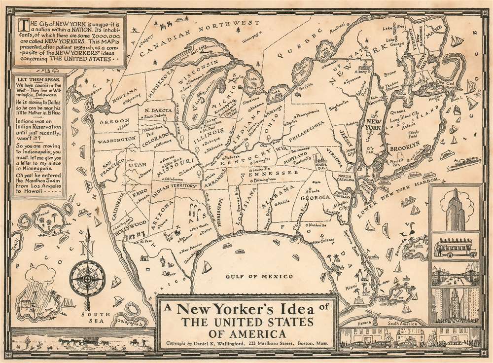
1939 Wallingford Map of the United States as seen by a New Yorker
1939 (dated) $495.00
1937 Wallingford Satirical Map of the United States
NewYorker-wallingford-1937$250.00

Title
A New Yorker's Idea of The United States of America
1937 (undated) 7 x 9.5 in (17.78 x 24.13 cm)
1937 (undated) 7 x 9.5 in (17.78 x 24.13 cm)
Description
This scarce and whimsical 1937 map depicts the United States, as seen by a 'typical' New Yorker - as envisaged by the Bostonian author, Daniel K. Wallingford. The map presents a highly distorted view of the country (and a similarly distorted view of the New Yorker), wherein New York State, and in particular Manhattan and Long Island are ludicrously out of proportion in relation to the rest of the country.
The map is a charming combination of humor and satire, depicting the provincialism of a New Yorker, to whom the rest of the country is unimportant. Names of places are either inaccurate or random, showing a New Yorker's supposed ignorance and disinterest in the rest of the country. The American southeast sports a massive Florida and four rivers, all named 'Swanee River'. Hollywood and San Francisco take up two-thirds of California and are shown as separate states. Minneapolis and Indianapolis are shown as 'twin cities' in Michigan, with Chicago, Milwaukee, St. Paul, Dubuque and Nebraska as cities in Illinois. Nevada is a city in Reno, and New Mexico is a city in Texas. The Great Salt Lake replaces Lake Superior, while Lake Michigan takes the name of Lake Superior. Lake Champlain is bigger than Lake Michigan, while Lake Erie is depicted as tiny lake in northern New York.
The map also includes beautiful illustrations of ships, whales, and islands; notable features of several states are also shown pictorially (e.g. the oil wells of Texas.) The lower right quadrant of the map includes four views of New York, including the Empire State building and the Fifth Avenue Coach. Another charming illustration along the lower border depicts a view of the desert and wagons on the left and a city and cars on the right. The upper left quadrant includes amusing text, attributed to actual New Yorkers: 'We have cousins in he west... they live in Wilmington, Delaware.' 'He is moving o Dallas so he can be near his mother in El Paso.' 'Indiana was an Indian Reservation until just recently, wasn't it?'.
Publication History and Census
This map was first published in 1936 by the Columbia University Press; Wallingford's imprint for that edition listed his address as 54 Falmouth Street. A second edition was produced in 1937 for the Times Book Fair, with the address changed to 222 Marlboro Street. (As is seen here.) A further edition was produced in a larger format for the occasion of the New York World's Fair on 1939.Cartographer
Daniel Kirkwood Wallingford (September 12, 1890 – January 11, 1964) was an American industrial designer and artist. He was born in St. Paul, Minnesota, the son of an architect. Wallingford, first came to national attention as a schoolboy in Indianapolis, when he was so moved by the 1898 explosion of the battleship Maine, off Cuba, that he he donated his life savings of 49 cents to the Dept. of the Navy with a note reading, 'I saved the money myself. I got part of it for having my tooth pulled and I save part of it from Christmas ... I wanted to help build a ship'. For his patriotism a steel-sheathed tugboat was named after him. Wallingford went on to attend Phillips Andover Academy, then Cornell University where studied Architecture and Industrial Design and was a member of the Sigma Chi Fraternity. From 1917 - 1919, he served in World War I (1914 - 1818) and as Lieutenant Colonel of Artillery in World War II (1939 - 1945). He is known for two important maps, New Yorker's View of the United States of America and The Bostonian's View of the United States of America. Both maps were revolutionary in the evolution of the American pictorial map for their satirical depiction of New York and Boston, respectively. The New Yorker's View, Wallingford's first map, was initially issued in 1932 in just 100 prints, which Wallingford distributed as Christmas gifts. The map proved so popular he revised it and proceed a second edition in 1935. Later, in March of 1976, a modified version appeared as a New Yorker cover. Shortly after moving to Boston in 1936, he issued his second map, the The Bostonian's View, also sold via mail order. A third less famous map, A Bookman's Idea of the United States was published in 1938. Wallingford was most likely inspired by John T. McCutcheon's 1922 New Yorker's View of the World and intern inspired a number of subsequent artists including John Roman (Cowboy America) and Ernest Dudley Chase (The United States as Viewed by California). Despite the near iconic popularity of his two famous maps, little is known of Wallingford's personal life. Wallingford died in 1964 and was survived by his wife, Margaret. More by this mapmaker...
Condition
Very good condition; margins close but complete.
References
OCLC 1029839422. Persuasive maps: PJ Mode Collection, Cornell University, PJM_1254_01.