
This item below is out of stock, but another example (left) is available. To view the available item, click "Details."
Details
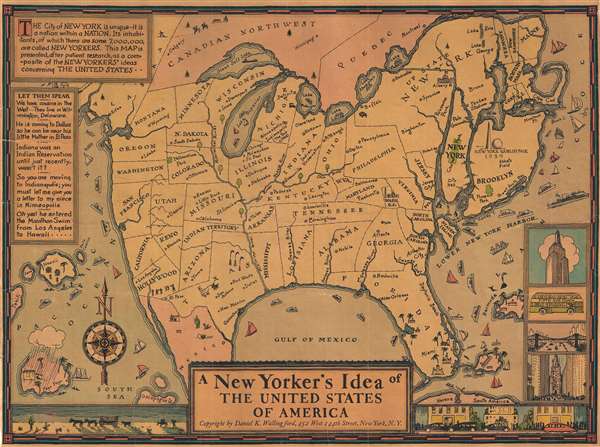
1939 Wallingford Map of the United States as seen by a New Yorker
$495.00
1939 Wallingford Map of the United States as seen by a New Yorker
NewYorker2-wallingford-1939$247.50

Title
A New Yorker's Idea of The United States of America
1939 (undated) 12 x 16 in (30.48 x 40.64 cm)
1939 (undated) 12 x 16 in (30.48 x 40.64 cm)
Description
This is a whimsical 1939 Daniel K. Wallingford pictorial map depicting a New Yorker's idea of the United States. Wallingford presents a humorously a distorted view of the United States, wherein New York State, Manhattan and Brooklyn, and other areas frequented by New Yorkers (Florida, Bermuda, etc.), are vastly outsized in proportion to the rest of the country. This edition was issued for the 1939 New York World's Fair, which is illustrated just north of Brooklyn.
The map also includes illustrations of ships, whales, islands etc. The lower right corner features four views of New York, including the Empire State building, St. Patrick's Cathedral, and the Fifth Avenue Coach. View's along the bottom incudes stylized depiction of the west as a land of stage coaches and desert, while on the right, the east features sleek futuristic cars and residential towers.
A Closer Look
The map is a charming combination of humor and satire, depicting the provincialism of 'some' New Yorkers, for whom certain part of the country are more significant than others. For example, southern United States is humorously depicted, with a massive Florida, and four rivers, each named 'Swanee River'. Hollywood and San Francisco take up two-thirds of California and are shown as separate states. Minneapolis and Indianapolis are shown as 'twin cities' in Michigan, with Chicago, Milwaukee, St. Paul, Dubuque and Nebraska as cities in Illinois. Nevada is a city in Reno, and New Mexico is a city in Texas. The Great Salt Lake replaces Lake Superior, while Lake Michigan takes the name of Lake Superior. Lake Champlain is bigger than Lake Michigan, while Lake Erie is depicted as tiny lake in northern New York.The map also includes illustrations of ships, whales, islands etc. The lower right corner features four views of New York, including the Empire State building, St. Patrick's Cathedral, and the Fifth Avenue Coach. View's along the bottom incudes stylized depiction of the west as a land of stage coaches and desert, while on the right, the east features sleek futuristic cars and residential towers.
Publication History and Census
This map has a confused and poorly understood publishing history. This earliest known state appeared in 1932, and is titled 'The New Yorker who has never been west of New Jersey…' The 1932 first state was revised with new border art in 1935. Relating to this revision, there is a signed letter by Wallingford, dated September 2, 1935, that included a black and white example of the map and a note that this is a 'revised' edition 'now available in three sizes' (8.5 x 6.6in, 12.5 x 10in, 20 x 15in). It is this edition that embraces the title 'A New Yorker's Idea…' The same letter also establishes Wallingford's address at the time as 119 Massachusetts Ave, Boston, suggesting that as the earliest address on record for the 1935 edition. Wallingford ultimately had multiple publication addresses, including: 231 Est 46th Street, New York (Copyright Wallingford 1932); 452 West 144th Street, New York (Copyright Wallingford, 1935); 119 Massachusetts Ave, Boston (Copyright Wallingford, c. 1936); 54 Falmouth Street, Boston (Wallingford c. 1946); 222 Marlborough Street, Boston (Copyright Wallingford, c. 1937); 452 West 144th Street, New York (Copyright Wallingford, c. 1939); New York (Columbia University Book Store, c. 1939). There is also a heavily revised edition issued in 1941. Additionally, Wallingford produced a similar map, the 'Bostonian's Idea of the United State of America', likewise in a confusing array of dates and editions.Cartographer
Daniel Kirkwood Wallingford (September 12, 1890 – January 11, 1964) was an American industrial designer and artist. He was born in St. Paul, Minnesota, the son of an architect. Wallingford, first came to national attention as a schoolboy in Indianapolis, when he was so moved by the 1898 explosion of the battleship Maine, off Cuba, that he he donated his life savings of 49 cents to the Dept. of the Navy with a note reading, 'I saved the money myself. I got part of it for having my tooth pulled and I save part of it from Christmas ... I wanted to help build a ship'. For his patriotism a steel-sheathed tugboat was named after him. Wallingford went on to attend Phillips Andover Academy, then Cornell University where studied Architecture and Industrial Design and was a member of the Sigma Chi Fraternity. From 1917 - 1919, he served in World War I (1914 - 1818) and as Lieutenant Colonel of Artillery in World War II (1939 - 1945). He is known for two important maps, New Yorker's View of the United States of America and The Bostonian's View of the United States of America. Both maps were revolutionary in the evolution of the American pictorial map for their satirical depiction of New York and Boston, respectively. The New Yorker's View, Wallingford's first map, was initially issued in 1932 in just 100 prints, which Wallingford distributed as Christmas gifts. The map proved so popular he revised it and proceed a second edition in 1935. Later, in March of 1976, a modified version appeared as a New Yorker cover. Shortly after moving to Boston in 1936, he issued his second map, the The Bostonian's View, also sold via mail order. A third less famous map, A Bookman's Idea of the United States was published in 1938. Wallingford was most likely inspired by John T. McCutcheon's 1922 New Yorker's View of the World and intern inspired a number of subsequent artists including John Roman (Cowboy America) and Ernest Dudley Chase (The United States as Viewed by California). Despite the near iconic popularity of his two famous maps, little is known of Wallingford's personal life. Wallingford died in 1964 and was survived by his wife, Margaret. More by this mapmaker...
Condition
Very good. Mounted on canvas, poster style. As with many examples of this map, the recto has been varnished producing an even toning.
References
OCLC 839295114. Persuasive maps: PJ Mode Collection, Cornell University, PJM_1254_01.