1917 Wanamaker Map of New York City and its Surrounds
NewYorkLongIsland-wanamaker-1917$250.00

Title
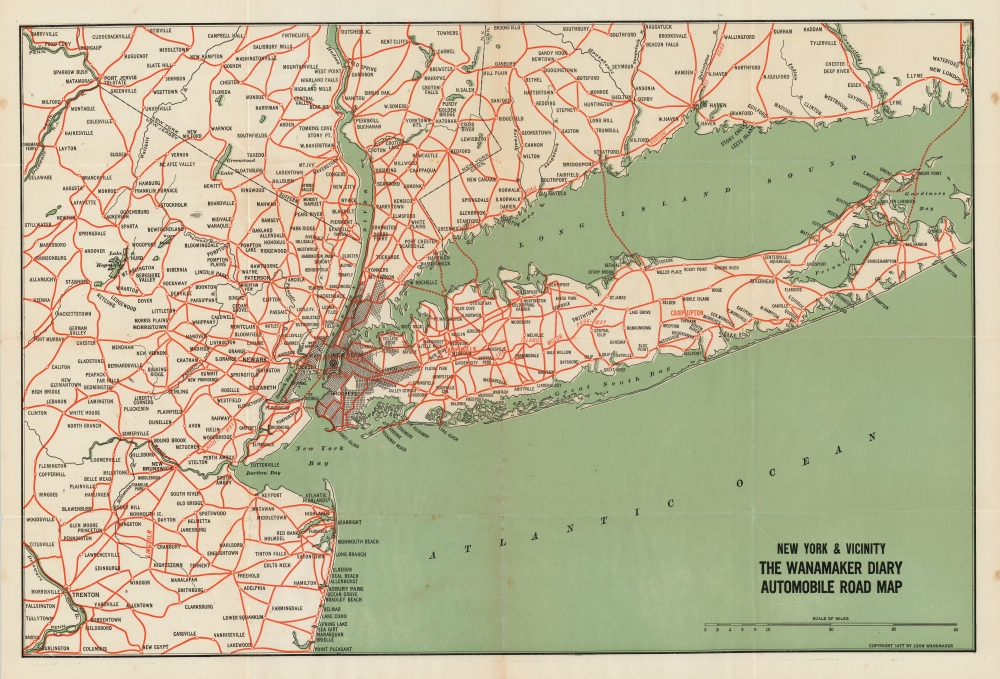
New York and Vicinity: The Wanamaker Diary Automobile Road Map.
1917 (dated) 16 x 24 in (40.64 x 60.96 cm) 1 : 400000
1917 (dated) 16 x 24 in (40.64 x 60.96 cm) 1 : 400000
Description
This is a fascinating 1917 map of the roads leading to New York City, published by the pioneer merchant and advertiser John Wanamaker. Wanamaker was among the first retailers to recognize the extent to which evolving technology and infrastructure would impact his businesses. When he opened the New York City branch of his Philadelphia-based department store, Wanamaker's, he located with direct access to the newly-opened New York City subway. Additionally, with the explosion of the automobile on the American landscape, Wanamaker was keen to show how easy it would be to drive to the store.
A Closer Look
The map extends as far east as New London, Connecticut (thus embracing all of Long Island) and as far west as the Delaware River; it reaches as far south as Burlington, New Jersey, and as far north as Barryville, New York (on the Hudson, both Cold Spring and West Point can be seen.)Wanamaker's Diary
One of Wanamakers' promotional products was an annual diary. This book contained space for daily entries, often with prompts (January 5: How are the resolutions coming along already?), and elements of an almanac, announcing expected events of the coming year. Other helpful features abounded: 'How to make a kitchen cabinet!' 'How to set a sundial!' Nonetheless, the diary most contained advertisements for Wanamaker's retail offerings. Wanamaker's produced separate Diaries for the New York and the Philadelphia stores, allowing for both regionally-specific features and advertisements. Beginning in 1916, the Philadelphia Diary included a plan of that city, and, beginning in 1917, the New York Diary contained the present map. From 1922, the New York Diary also included a Bird's Eye View of the city, produced by Hammond.The Roads
The map is printed in three colors: black outline, green for water, and red for roads. While no route numbers are given, several important early roads are named: the New Jersey portion of the Lincoln Highway (the first transcontinental highway in the United States) is labeled, as is the Long Island Motor Parkway, the first roadway designed exclusively for automobile use. Along the Long Island Sound, the Boston Post Road is labeled. Ferries from Long Island, Connecticut, and Staten Island are marked with red dotted lines. Of course, in Manhattan, both a black bulls-eye and red text highlight Wanamaker's East Village location.A Great War Connection
Also in red on Long Island are Camp Mills and Camp Upton. Camp Mills was a military installation established in September 1917 as a staging ground for the Army. It had a capacity of 40,000 soldiers intended for embarkation for Europe during World War I (1914 - 1918). With the end of the war, Camp Mills reversed direction and served to process returning troops. The camp ceased operations in 1920. Camp Upton, too, was created in 1917 to house troops en route to Europe. It would also serve to process demobilized soldiers at the war's end. In 1919 it became a Recruit Educational Center. This was an Army program to train foreign-born, non-English speaking, and illiterate soldiers - primarily immigrants from Eastern and Southern Europe - providing an education, eligibility for military service, and naturalization as American citizens. Ironically, at the outbreak of World War II (1939 - 1945), Camp Upton was employed as an internment site for German, Italian, and Japanese citizens who were in New York City at the war's outbreak. Internees remained confined there until 1943, when they were transferred to Fort Meade in Maryland. In 1946, the site was converted into a nuclear research facility, renamed the Brookhaven National Laboratory.Publication History and Census
The map was included in Wanamaker's Diary beginning in 1917 until about 1922. As no publisher is named, it was very likely entirely an in-house production by Wanamaker's, who appear to have had a printing operation as well as a full-time copywriter. The separate map is cataloged four times in OCLC.Cartographer
John Wanamaker (July 11, 1838 - December 12, 1922) was an American merchant and public figure, and a pioneer in advertising and marketing. Born in Philadelphia, Pennsylvania, he would found the famous department stores that carried his name. Later in life he served as U.S. Postmaster General during the term of President Benjamin Harrison, (1889 - 1893.) He opened his first, Philadelphia store - Oak Hall - in 1861; his second store opened in 1869, and this one would be named John Wanamaker and Co.; in 1875, he moved the growing business into an abandoned railroad depot and converted it into what is considered the first department store in Philadelphia. The 12-story Grand Depot, with its Grand Court, pipe organ, iconic Eagle statue, and holiday light shows became an institution. In 1896 Wanamaker expanded into New York City, taking over space that had been established by A. T Stewart. He expanded again into an adjacent, newly-built 14-story edifice which Wanamaker cannily had built with its 32 acres of retail space directly accessible via the new Astor Place subway station. A proponent of the power of advertising, he was the first retailer to place half and later full-page newspaper advertisements, eventually hiring the world's first full-time copywriter to fuel his circulars. The arrival of Wanamaker's stores in New York was spearheaded with a vigorous newspaper campaign, including the clever innovation of producing the first subway map intended for use by its ridership. More by this mapmaker...
Source
Wanamaker, John, The Wanamaker Diary,(Philadelphia: Wanamaker) 1917-1920.
Condition
Very good. Three-color printing. Original fold lines, mend at juncture of folds in water area not impacting body of map.
References
OCLC 5483685.