1747 Bowen Map of New Jersey, Pennsylvania, New York, and New England
NewYorkNewEngland-bowen-1747-2$1,200.00

Title
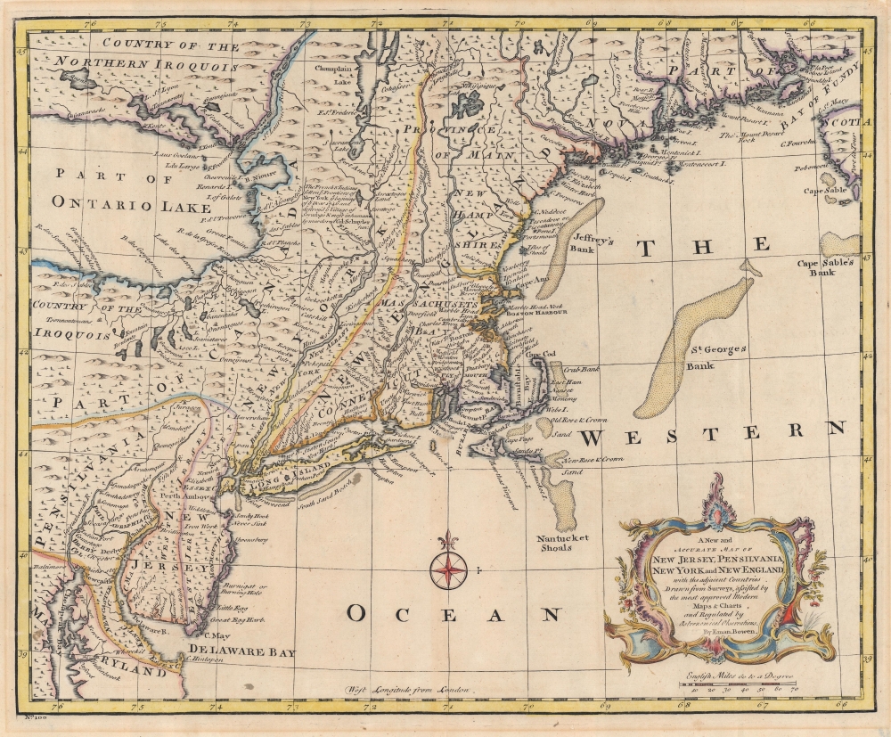
A New and Accurate Map of New Jersey, Pensilvania, New York and New England with the adjacent Countries.
1747 (undated) 14 x 17 in (35.56 x 43.18 cm) 1 : 2250000
1747 (undated) 14 x 17 in (35.56 x 43.18 cm) 1 : 2250000
Description
A 1747 Emmanuel Bowen map of the New England and Middle-Atlantic colonies, covering New Jersey, New York, Pennsylvania, Maine, New Hampshire, and Connecticut. Covering from the Chesapeake Bay to Lake Champlain and Lake Ontario to Nova Scotia, this map exemplifies the successes and failures of 18th-century English mapping in the American colonies. It also makes evident the challenges of the European map publisher in piecing together disparate reports and mappings into a single cohesive cartographic entity.
Successes and Failures
In this example, the contrast is most strikingly elucidated in Bowen's relatively accurate mapping of the coastlines in contrast to the vagueness of the interior. A simple overlay with a modern map reveals that while Bowen's longitudinal cartography along the coastline is slightly off from Cape Cod westward, his latitudinal reference points are dead on. Heading inland from the Atlantic, this precision quickly evaporates. Lake Ontario is proportionally massive and situated several hundred miles too far east. Despite Bowen's considerable errors in proportion and positioning, the Lake Ontario shoreline is surprisingly accurate in form, and detailed down to the Finger Lakes extending south from the main body.Intriguing Political Detail
Politically, Bowen offers interesting detail regarding the early boundary lines of the colonies. New Jersey is divided into the provinces of East and West Jersey. Pennsylvania is defined as the undeveloped lands to the west of the Susquehanna River. The lands to the east of the Susquehanna River, as far as the Delaware River, are assigned to the Philadelphia Company. The inland borders between the Massachusetts Bay Colony, Connecticut, and New York are indistinct. Canada extends south to the Pennsylvania border. Bowen identifies the important cod fishing shoals off New Hampshire, Cape Cod, and Nantucket. He also adds a number of notations regarding the events that occurred near Albany, New York, in 1746, during King George's War (1744 - 1748), the third of the four French and Indian Wars.Publication History and Census
This map was created and published by Emanuel Bowen for inclusion as plate no. 100 in the 1747 edition of A Complete System of Geography. Scarce to the market.Cartographer
Emanuel Bowen (1694 - May 8, 1767) had the high distinction to be named Royal Mapmaker to both to King George II of England and Louis XV of France. Bowen was born in Talley, Carmarthen, Wales, to a distinguished but not noble family. He apprenticed to Charles Price, Merchant Taylor, from 1709. He was admitted to the Merchant Taylors Livery Company on October 3, 1716, but had been active in London from about 1714. A early as 1726 he was noted as one of the leading London engravers. Bowen is highly regarded for producing some of the largest, most detailed, most accurate and most attractive maps of his era. He is known to have worked with most British cartographic figures of the period including Herman Moll and John Owen. Among his multiple apprentices, the most notable were Thomas Kitchin, Thomas Jeffreys, and John Lodge. Another apprentice, John Oakman (1748 - 1793) who had an affair with and eventually married, Bowen's daughter. Other Bowen apprentices include Thomas Buss, John Pryer, Samuel Lyne, his son Thomas Bowen, and William Fowler. Despite achieving peer respect, renown, and royal patronage, Bowen, like many cartographers, died in poverty. Upon Emanuel Bowen's death, his cartographic work was taken over by his son, Thomas Bowen (1733 - 1790) who also died in poverty. More by this mapmaker...
Source
Bowen, E., A complete system of geography. Being a description of all the countries, islands, cities, chief towns, harbours, lakes, and rivers, mountains, mines, etc. of the known world, (London) 1747.
Condition
Very good. Centerfold reinforcement. Verso repair to centerfold separation. Small areas of infill in margins.
References
Library of Congress, Map Division, G3710 1747 .B6 Vault. National Maritime Museum, p. 356. Phillips (America), p. 469. Rumsey 3733.061. McCorkle, B. B., A Carto-Bibliography of the Maps in Eighteenth-Century British and American Geography Books, 744.4. OCLC 49703793.