1846 Bradford Map of New York
NewYorkState-bradford-1846$250.00

Title
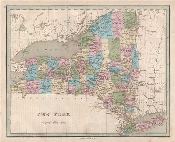
New York.
1846 (dated) 12 x 14.75 in (30.48 x 37.465 cm) 1 : 1850000
1846 (dated) 12 x 14.75 in (30.48 x 37.465 cm) 1 : 1850000
Description
This is an 1846 Thomas G. Bradford map of New York. The map depicts the region from Lake Erie and Ontario, Canada to Vermont and from Canada to Pennsylvania and New Jersey. As is prevalent among many maps from Bradford's A Universal Illustrated Atlas, the transportation network in New York is prominently featured, especially the network of canals and the newly-constructed railroads.
Canals in New York
The centerpiece of transportation in New York during this time in American history was the Erie Canal. Completed in 1825, the Canal connected the Hudson River at Albany to Lake Erie and Buffalo. At the time, the Erie Canal was the longest canal in the world. Upon its completion, goods could be transported by water from New York City to Chicago, a much less hazardous and time-consuming voyage than overland treks. Numerous other canals are illustrated, although they are not labeled. These include the Erie and Champlain Canal which connected the Erie Canal with Lake Champlain at Whitehall, the Oswego Canal between Syracuse and Oswego, the Chenango Canal between the Erie Canal at Utica to Binghampton, and several others. The construction of this extensive canal system led officials in New York to try and protect their investment by seriously restricting the construction of railroads within the state. In doing so, that would, theoretically, guarantee that the transport of goods would be carried out using the canals.
Highly detailed, each county is illustrated, labeled, and shaded a different color to allow for easy differentiation. Numerous cities and towns are labeled, including New York, Brooklyn, Albany, Syracuse, and Buffalo. Myriad rivers and lakes are depicted and labeled throughout the state as well.
Canals in New York
The centerpiece of transportation in New York during this time in American history was the Erie Canal. Completed in 1825, the Canal connected the Hudson River at Albany to Lake Erie and Buffalo. At the time, the Erie Canal was the longest canal in the world. Upon its completion, goods could be transported by water from New York City to Chicago, a much less hazardous and time-consuming voyage than overland treks. Numerous other canals are illustrated, although they are not labeled. These include the Erie and Champlain Canal which connected the Erie Canal with Lake Champlain at Whitehall, the Oswego Canal between Syracuse and Oswego, the Chenango Canal between the Erie Canal at Utica to Binghampton, and several others. The construction of this extensive canal system led officials in New York to try and protect their investment by seriously restricting the construction of railroads within the state. In doing so, that would, theoretically, guarantee that the transport of goods would be carried out using the canals.
Railroads in New York
A handful of railroads, however, were constructed, such as the Long Island Railroad (illustrated here in red) and the lines that would become the New York, New Haven, and Hartford Railroad. The New York and Harlem Railroad (now Metro-North's Harlem Line), one of the first railroads in the United States, is also illustrated. Incorporated in 1831, the first section of track, along Bowery from Prince Street to 14th Street, opened in 1832.Highly detailed, each county is illustrated, labeled, and shaded a different color to allow for easy differentiation. Numerous cities and towns are labeled, including New York, Brooklyn, Albany, Syracuse, and Buffalo. Myriad rivers and lakes are depicted and labeled throughout the state as well.
Publication History
This map was engraved by George Boynton and published in the 1846 edition of Bradford and Goodrich's A Universal Illustrated Atlas.CartographerS
Thomas Gamaliel Bradford (1802 - 1887) was born in Boston, Massachusetts, where he worked as an assistant editor for the Encyclopedia Americana. Bradford's first major cartographic work was his revision and subsequent republishing of an important French geography by Adrian Balbi, Abrege de Geographie published in America as Atlas Designed to Illustrate the Abridgment of Universal Geography, Modern and Ancient. Afterwards Bradford revised and expanded this work into his own important contributions to American cartography, the 1838 An Illustrated Atlas Geographical, Statistical and Historical of the United States and Adjacent Countries. Bradford's cartographic work is significant as among the first to record Texas as an independent nation. In his long career as a map publisher Bradford worked with William Davis Ticknor of Boston, Freeman Hunt of New York, Charles De Silver of Philadelphia, John Hinton, George Washington Boynton, and others. We have been able to discover little of Bradford's personal life. More by this mapmaker...
George Washington Boynton (fl. c. 1830 - 1850) was a Boston based cartographer and map engraver active in the first half of the 19th century. Boynton engraved and compiled maps for numerous publishers including Thomas Bradford, Nathaniel Dearborn, Daniel Adams, and S. G. Goodrich. His most significant work is most likely his engraving of various maps for Bradford's Illustrated Atlas, Geographical, Statistical, and Historical, of the United States and the Adjacent Countries and Universal Illustrated Atlas. He also engraved for the Boston Almanac. In 1835, Boynton is listed as an employee of the Boston Bewick Company, an engraving, stereotype, and printing concern based at no. 47 Court Street, Boston. Little else is known of his life. Learn More...
Source
Bradford, T. G. and Goodrich, S. G., A Universal Illustrated Atlas, exhibiting a Geographical, Statistical, and Historical view of the World, (Boston: Charles D. Strong) 1846.
The Universal Illustrated Atlas is one of the great American atlases of the first half of the 19th century. The atlas was first published in 1838 under the imprint of Charles D. Strong. It replaced and superseded Bradford's earlier smaller format Illustrated Atlas, Geographical, Statistical, and Historical, of the United States and the Adjacent Countries. Numerous reissues of the Universal Illustrated Atlas followed until about 1848. Although there are minor variations between the editions, most contain about 50 maps, the majority of which focus on the United States. Bradford's atlases are significant for recording North America during the Republic of Texas Era. In later editions, particularly the 1846 edition, Bradford illustrates the boom in railroad construction, possibly with the idea that his maps would aid travelers in planning journeys by rail. It was compiled by Thomas Gamaliel Bradford and Samuel Griswold Goodrich with most of the plates engraved by George Washington Boynton (fl. c. 1830 - 1850). Other contributors include Thomas Gordon (1778 - 1848), Fielding Lucas Jr. (1781 - 1854), Samuel Edward Stiles (1844 - 1901), Sherman and Smith (fl. c. 1829 - 1855), and Horace Thayer (1811 - c. 1874).
Condition
Very good. Even overall toning. Blank on verso.
References
Rumsey 0089.014 (1838 edition).