1966 Hagstrom Map of Midtown Manhattan Theatres, New York City
NewYorkTheatres-hagstrom-1966$400.00

Title
Hagstrom's Map of New York Area of Greatest Interest: Theatres, Hotels, Motels, Shopping District
1966 (undated) 33.25 x 26.5 in (84.455 x 67.31 cm) 1 : 4350
1966 (undated) 33.25 x 26.5 in (84.455 x 67.31 cm) 1 : 4350
Description
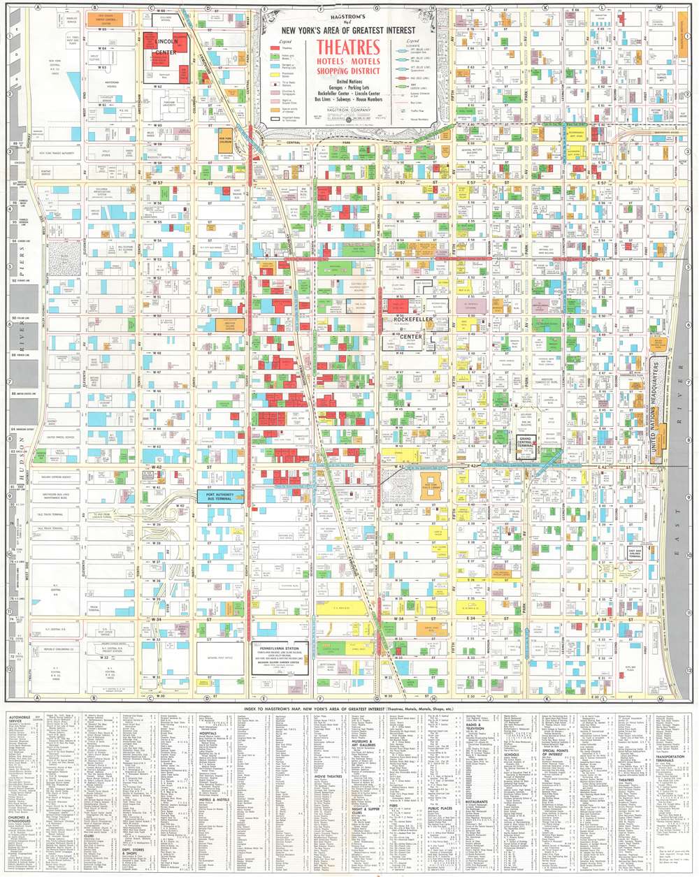
This is a c. 1966 Hagstrom map of Midtown Manhattan highlighting the Theatre District and its many theatres. The map depicts the city from the West Side Highway and the Hudson River Piers to the East River and from West 66th Street, Central Park, and East 66th Street to 30th Street. Although myriad buildings are illustrated, not all the city blocks are filled. Theatres, hotels and motels, garages or parking lots, prominent stores, tv or radio stations, churches and synagogues, night or supper clubs, and special points of interest are shaded using various colors to allow for easy differentiation and identification.
Theatres, Museums, and More
The focus, of course, is on the areas many theatres, which are shaded red. Numerous theatres still in operation today are labeled here, including the New Amsterdam, Lyric, Majestic, Broadhurst, Booth, Golden, Barrymore, and the Music Box. Lincoln Center, where the Metropolitan Opera House would open the following year, appears in the upper left quadrant. Numerous others illustrated here have since been closed or repurposed. The United Nations Headquarters, located along the East River between East 42nd Street and East 48th Street, is illustrated and the Secretariat Building, the Meeting Halls, and the Assembly Hall are all labeled. Other New York City landmarks that fall within the map's borders include the Empire State Building, the central branch of the New York Public Library, the Museum of Modern Art (MoMA), Bryant Park, Grand Central Station, and Herald Square. Both Macy's and Bloomingdale's are labeled, as are the Waldorf Astoria Hotel and the Plaza Hotel. An index, situated along the bottom of the map, lists the identified locations and each building's location on the map's grid. Streets and avenues are also labeled and subway lines are illustrated and identified as well.Publication History and Census
This map was created by the Hagstrom Company and published c. 1966. We have identified at least three different editions of this map that were published between c. 1940 and c. 1966. Each of these editions vary in rarity.Cartographer
Andrew Gunnar Hagstrom (1890 - September 24, 1977) was a map publisher based in Maspeth, Queens. Hagstrom was a Swedish immigrant who came to new York in 1909 where took work milking cows at a farm near Coney Island, Brooklyn. He then worked in the meat packing industry while taking a degree in commercial art at the New York Mechanics Institute. Afterwords he founded a drafting business in Manhattan, creating a map to illustrate his drafting skill help customers locate his shop. His map proved popular and he expanded operations, founding the Hagstrom Map Company (1916 - 1968) and issuing additional maps of various parts of New York City and the surrounding regions. By 1949, Hagstrom had issued more than 150 maps, guides, and atlases, most of which focused on New York. Hagstrom pioneered a cartographic style that exaggerated street size to increase clarity and create additional room for large print readable labeling. Even the New York Subway system hired Hagstrom to produce its map, which was in use from the 1940s to 1958. Hagstrom died in 1977, at the age of 81. Hagstrom was knighted by the King of Sweden. His company flourished until 1968 when it was acquired by Macmillan. The brand has since passed through multiple corporate portfolios and is currently the property by Kappa Publishing Group. More by this mapmaker...
Condition
Good. Exhibits light wear along original fold lines. Exhibits closed tears, reinforced weak areas, and other wear where once attached to a binder. Closed tear extending two-and-three-quarters (2.75) inches into printed area from top margin professionally repaired on verso.