This item has been sold, but you can get on the Waitlist to be notified if another example becomes available, or purchase a digital scan.
1865 Viele Waterway Map of New York City
NewYorkWaterways-viele-1865$4,500.00

Title
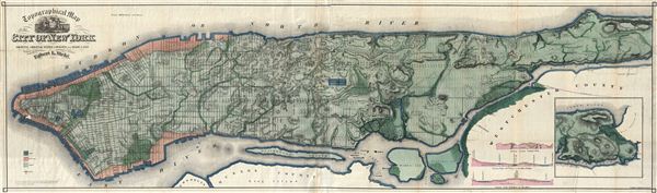
Topographical Map of the City of New York Showing Original Water Courses and Made Land.
1865 (dated) 17.5 x 63 in (44.45 x 160.02 cm)
1865 (dated) 17.5 x 63 in (44.45 x 160.02 cm)
Description
 This is Egbert L. Viele's 1865 topography and waterways map of Manhattan, one of the scarcest, most important and most enduring maps of New York City ever published. Covering the entirety of Manhattan Island, Viele's map details the canals, swamps, rivers, ditches, ponds, meadows, and drainage basins of Manhattan as they existed prior to the city's urban development. A version of the Viele map remains in use today by architects and contractors who need to be certain they are not building over underground rivers and swamps that may destabilize a new construction's foundation.
Roughly translated 'Manhattan' is an American Indian term meaning 'Island of Hills.' The American Indians living in the region prior to the Dutch settlement of Manhattan treated the island as a huge hunting and fishing reserve full of trout streams, bass swamps, and sunfish ponds. Viele contended that as streets and buildings were constructed the city's natural drainage retreated underground where, stagnating, it led to a 'humid miasmic state of the atmosphere' conducive to yellow fever, malaria, plague, and other epidemic illnesses.
Viele dedicated nearly 20 years to researching and perfecting this masterpiece of cartography. The basic map and above ground topography of the Viele map is drawn from John Randel's surveys of 1807 and the Commissioner's Plan of 1811, which formally laid out New York City's grid system. Viele then used early survey work, new survey work, and studies of older maps to recreate Manhattan's water system as it must have existed when the first Dutch settlers built a fur trading post of the tip of the island. Viele presented an unfinished early state of his map, covering only lower Manhattan to the New York State Senate in 1859, claiming, 'The Sanitary condition of any city or district or country is intimately connected with its proper drainage . . . that any inquiry into causes or remedies for sanitary evils . . . shall be based upon a thorough knowledge of the topography of the island.' It took another six years of meticulous study to produce the final product – this extraordinary achievement.
Though Viele may never have imaged his map's most important legacy would be as a construction aid, architects, engineers, and contractors were quick to grasp the usefulness of the map. Paul Starett, who built the Empire State Building and Stuyvesant Town, used this map to prepare estimates of construction costs. Melvin Febish, part of the team constructing the Citicorp Center, 'found that it's accurate within feet.' The builders of our own apartment building, at 105th and Amsterdam, may not have consulted this map, for had they done so they may have noticed the underground river that has caused innumerable foundation problems in the 80 plus years since it was built.
This edition of Viele's 'Topographical Map of the City of New York' was issued to accompany his manifesto calling for future city development to take natural waterways and drainage into account when planning expansion. It is the first complete state of Viele's map and comes with its original green leatherette binder and text, which the author (Viele) has inscribed to a mysterious 'Ches Davis.' Haskell, in his cartobibliography of Manhattan maps, for some reason identifies this map as being issued in 1864, but no known example exists from that date, nor are there any recorded copyrights on this map from 1864. The first complete edition is this, 1865.
In closing we would like to make a final comment on condition. This map was issued on two joined panels, printed on fine bank note paper, and folded for issue in various publications. Consequently most examples exhibit considerable wear and damage along the original fold lines as well as cropped or off-center borders, general wear, soiling, water damage, and color loss. This example, on the other hand, is in near pristine condition. We have had it professionally removed from its original binder and flatted with archival tissue added for backing and support. Its color is original and remarkably vivid with no signs of the degradation typical on maps from this period. If you hope to add an example of this map to your collection, this is a once in a lifetime opportunity.
Cartographer
Egbert Ludovicus Vielé (June 17, 1825 - April 22, 1902) was an American civil engineer, cartographer, businessman, and politician active in New York City during the second half of the 19th century. Born in Saratoga County, Vielé attended the United States Military Academy at West Point. Graduating in 1847, he was commissioned as a brevet second lieutenant in the 2nd United States Infantry. He served in the Mexican-American War before resigning form military duty to pursue a career as a Civil Engineer in New York City. When the call came to plan New York City's Central Park in 1856, Vielé was established as Engineer-in-Chief of the project, and it was he who set down the guidelines by which Vaux and Olmstead ultimately planned the park. He held a similar position as engineer of Prospect Park, Brooklyn from 1860. It was most likely during his tenure with the park commissions that Vielé developed his theories connecting compromised natural drainage with sanitation and infectious disease. Vielé's great cartographic masterpiece, the Topographical Map of the City of New-York, euphemistically known as the 'Vielé Map' or 'Waterways Map' evolved out of the notion that epidemic level disease evolved from excess moisture in the soil. He contended that, as New York City expanded northwards, paving over stream beds and leveling out natural drainage channels, the underground waterways would stagnate and lead to plague or worse. Though intended for the purpose of urban planning, the Vielé Map's (as it came to be known) greatest legacy is as a construction tool. To this day, contractors, architects, and engineers consult the Vielé map to determine if unseen subterranean waterways need to be taken into account when preparing building foundations. He was elected as a Democratic representative to the Forty-ninth Congress (March 4, 1885 – March 3, 1887) and ran unsuccessfully for re-election in 1886. He was heavily involved in New York real-estate interests, but also owned shares of mining and railroad companies as far off as Colorado. Vielé died in April of 1902 and was buried in an elaborate Egyptian Revival tomb at West Point. Legend tells that Vielé, paranoid that he would be buried alive, an unfortunate but surprisingly common problem in the 19th century, installed a buzzer inside his coffin that would allow him to ring the school's commanding officer should the need arise. Apparently, it did not. More by this mapmaker...
Source
Viele, E. L, Topography & Hydrology of theCity of New-York, (Robert Craighead, New York) 1865.
Condition
Very good condition. Professionally removed from binder, flattened, and archivally backed with Japanese tissue. Minor area of loss in lower Manhattan - see image. Original green leatherette binder with author's inscription included. The finest example of this extremely rare map we have encountered.
References
Rumsey 3723.000. Augustyn, R. T. and Cohen, P. E., Manhattan in Maps, p. 136 - 139. Haskell, Daniel, Manhattan Maps, A Co-operative List, 1132. Stokes, I. N. P., The Iconography of Manhattan Island, 1498-1909, Compiled from Original Sources and Illustrated by Photo-Intaglio Reproductions of Important Maps, Plans, Views and Documents in Public and Private Collections, vol 3, p.777-778.