This item has been sold, but you can get on the Waitlist to be notified if another example becomes available, or purchase a digital scan.
1850 John Arrowsmith Map of New Zealand
NewZealand-arrowsmith-1850$825.00

Title
Map of the colony of New Zealand, from official documents.
1850 (dated) 22.25 x 19.25 in (56.515 x 48.895 cm) 1 : 1800000
1850 (dated) 22.25 x 19.25 in (56.515 x 48.895 cm) 1 : 1800000
Description
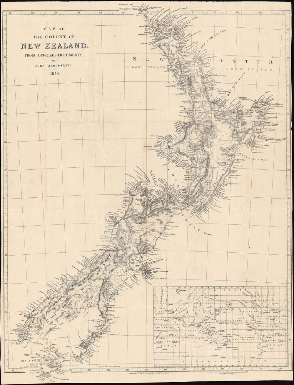
This is a striking 1850 map of New Zealand by John Arrowsmith. It shows the colony in the early days of a surge of immigration from Britain and other British colonies that would drastically alter New Zealand society and environment.
This map was made during a period when New Zealand was undergoing dramatic changes. Having started out as an offshoot of New South Wales where trade and relations with the Māori were generally amicable, interests in both commerce and colonial settlement ramped up with the royal chartering of the New Zealand Company in 1840. Afterwards, thousands of settlers arrived, many of whom were young couples who built large families in the new colony, growing the White population, causing land disputes with the Māori, and completely transforming the landscape to accommodate European-style agriculture. Meanwhile, disease, warfare, and cultural assimilation reduced the Māori population with similar rapidity.
Soon after this map's publication, New Zealand gained a Parliament and local administration. Despite holding a royal charter, the company was often at odds with royal representatives, including governors of New South Wales and later local governors, who were primarily interested in maintaining peace with the Māori and reining in the lawlessness among settlers and European and American whalers who operated in the waters off the islands.
A Closer Look
This map covers the islands composing the colony of New Zealand, indicating from the Three Kings (Manawatāwhi), just beyond the scope of this map to the north, down through Stewart Island (Rakiura) to the south. The coastline along with coastal mountains and rivers are covered with especially close attention to detail. On the other hand, the geography of some of the interior parts of the islands were not well understood, including Otago, at bottom, which would soon see a rapid influx of outsiders during a gold rush in the 1860s. An inset map of the world centered on the western Pacific is located at bottom-right.This map was made during a period when New Zealand was undergoing dramatic changes. Having started out as an offshoot of New South Wales where trade and relations with the Māori were generally amicable, interests in both commerce and colonial settlement ramped up with the royal chartering of the New Zealand Company in 1840. Afterwards, thousands of settlers arrived, many of whom were young couples who built large families in the new colony, growing the White population, causing land disputes with the Māori, and completely transforming the landscape to accommodate European-style agriculture. Meanwhile, disease, warfare, and cultural assimilation reduced the Māori population with similar rapidity.
Soon after this map's publication, New Zealand gained a Parliament and local administration. Despite holding a royal charter, the company was often at odds with royal representatives, including governors of New South Wales and later local governors, who were primarily interested in maintaining peace with the Māori and reining in the lawlessness among settlers and European and American whalers who operated in the waters off the islands.
Publication History and Census
This map was made by John Arrowsmith in 1850. An earlier edition appeared in the 1844 edition of Arrowsmith's London Atlas of Universal Geography, though the engraving in the present example is considerably more elaborate and appears to be a separate issue rather than an atlas map (no subsequent edition of the London Atlas was published before 1858). We note 14 listings of this map in the OCLC and it is scarce to the market.Cartographer
Aaron Arrowsmith (1750-1823), John Arrowsmith (1790-1873), and Samuel Arrowsmith. The Arrowsmith family were noted map engravers, publishers, geographers, and cartographers active in the late 18th and early 19th century. The Arrowsmith firm was founded by Aaron Arrowsmith, who was trained in surveying and engraving under John Cary and William Faden. Arrowsmith founded the Arrowsmith firm as a side business while employed by Cary. The firm specialized in large format individual issue maps containing the most up to date and sophisticated information available. Arrowsmith's work drew the attention of the Prince of Wales who, in 1810, named him Hydrographer to the Prince of Wales, and subsequently, in 1820, Hydrographer to the King. Aaron Arrowsmith was succeeded by two sons, Aaron and Samuel, who followed him in the map publication business. The Arrowsmith firm eventually fell to John Arrowsmith (1790-1873), nephew of the elder Aaron. John was a founding member of the Royal Geographical Society. The firm is best known for their phenomenal large format mappings of North America. Mount Arrowsmith, situated east of Port Alberni on Vancouver Island, British Columbia, is named for Aaron Arrowsmith and his nephew John Arrowsmith. More by this mapmaker...
Condition
Very good. Fold lines visible. Offsetting present, especially at top-left.