This item has been sold, but you can get on the Waitlist to be notified if another example becomes available, or purchase a digital scan.
1896 Calvert Map of Lake Winnipesaukee and the Lakes Region, New Hampshire
NHLakesRegion-calvert-1896$200.00

Title
Calvert's Map of the Lake Region in New Hampshire, U. S. A.
1896 (dated) 17.75 x 27.75 in (45.085 x 70.485 cm) 1 : 63360
1896 (dated) 17.75 x 27.75 in (45.085 x 70.485 cm) 1 : 63360
Description
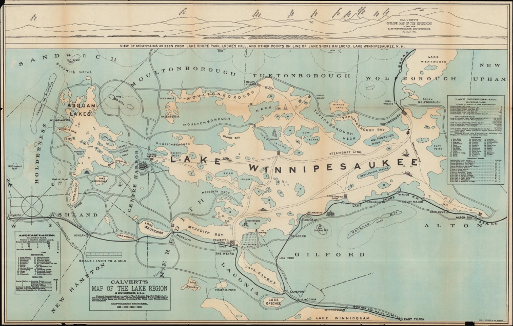
A fascinating 1896 map of the Lakes Region of New Hampshire, prepared by M. H. Calvert and printed by George H. Walker and Co. It is designed with tourists in mind, emphasizing hotels, attractions, and rail lines.
Hotels, boats, wharves, rail lines, roads, steamboat lines, and other features, including the location of Calvert's Weirs Times, are illustrated throughout. A view along the top displays the peaks of the White Mountains to the north, while on the map, the elevations of smaller peaks near the lakes are noted. Statistical tables of Lake Winnipesaukee and Asquam Lakes at right and left, respectively, provide information on the lakes, tables of distances between major points, and indexes of island names corresponding to numbers on the map (larger islands and necks are named on the map itself). The Boston and Maine Railroad, which acquired earlier regional lines (namely the Boston and Lowell), and the Lake Shore Railroad, are traced in black. In the late 19th century, railroads and steamships worked in tandem to transport passengers from Boston and New York City, primarily, and shuttle them around Lake Winnipesaukee. The connection was so close that the Boston and Maine Railroad built a paddle-steamer, the Mount Washington, in 1872 to carry passengers, goods, and mail around Lake Winnipesaukee. (A passenger service still operates under this name, albeit using a more recent ship equipped with diesel engines.)
A Closer Look
Oriented towards the northeast, this map covers much of the Lakes Region of New Hampshire, including Lake Winnipesaukee and the 'Asquam Lakes' (also known as Squam Lake and Little Squam Lake) in their entirety. Portions of neighboring lakes, including Lake Winnisquam and Lake Wentworth, are also included, as is Lake Paugus, now considered a bay within Lake Winnipesaukee. The map adopts an unusual coloration, whereby land is shaded blue, and the lakes and other waterways are white. Towns are named, with their borders outlined, while stops along the rail lines are marked with circles.Hotels, boats, wharves, rail lines, roads, steamboat lines, and other features, including the location of Calvert's Weirs Times, are illustrated throughout. A view along the top displays the peaks of the White Mountains to the north, while on the map, the elevations of smaller peaks near the lakes are noted. Statistical tables of Lake Winnipesaukee and Asquam Lakes at right and left, respectively, provide information on the lakes, tables of distances between major points, and indexes of island names corresponding to numbers on the map (larger islands and necks are named on the map itself). The Boston and Maine Railroad, which acquired earlier regional lines (namely the Boston and Lowell), and the Lake Shore Railroad, are traced in black. In the late 19th century, railroads and steamships worked in tandem to transport passengers from Boston and New York City, primarily, and shuttle them around Lake Winnipesaukee. The connection was so close that the Boston and Maine Railroad built a paddle-steamer, the Mount Washington, in 1872 to carry passengers, goods, and mail around Lake Winnipesaukee. (A passenger service still operates under this name, albeit using a more recent ship equipped with diesel engines.)
Boston and Maine Railroad
Commonly known as the 'B and M', the Boston and Maine Railroad was chartered in New Hampshire on June 27, 1835. The firm consolidated several smaller companies, including the Andover and Haverhill Railroad and later the Boston and Portland Railroad. It merged with the Maine, New Hampshire and Massachusetts Railroad in 1842, but retained the Boston and Maine operating name. In the subsequent decades, it acquired or leased several other railroads, including the Boston and Lowell (1887), Northern (1884), Connecticut River (1893), Concord and Montreal (1887), and Fitchburg (1900). In 1910, J. P. Morgan and his New York, New Haven and Hartford Railroad acquired the Boston and Maine Railroad. The firm initially prospered on the development of mill towns throughout New England and later capitalized on tourism from urban centers, such as Boston and New York. Nonetheless, the railroad declined during the Great Depression and when most of the old textile mills closed. Part of the Boston and Maine network remains in operation today under the Pan Am Railways (PAS) brand.Publication History and Census
This map was prepared by Matthew H. Calvert, publisher of Calvert's Weirs Times and Tourists' Gazette, a seasonal publication produced during summer months. It is based on surveys undertaken by William P. Crocker (in the 1840s) and was printed by George H. Walker and Co. in Boston in 1896. This map was published in multiple editions, as indicated in the copyright information in the title box, though these appear to have varied considerably in size and style. The Boston Public Library holds an example identical to the present one except that it has a yellow coloration rather than blue, whereas Harvard University and the New Hampshire Historical Society hold smaller black-and-white examples where the Asquam Lakes table is replaced by advertising. We are only aware of these three examples in institutional collections or on the market.CartographerS
Matthew H. Calvert (November 21, 1861 - April 7, 1922) was an English-born editor and publisher based in 'the Weirs' or Weirs Beach, on the shores of Lake Winnipesaukee in New Hampshire. Calvert's Weirs Times and Tourists' Gazette was an important resource for tourists to the Lakes Region in the closing years of the 19th century. Little is known about Calvert's life and other work. He is noted as having immigrated to the U.S. in 1883. His publishing enterprise may not have been successful, as he is noted as working as a farmer in the last years of his life. More by this mapmaker...
George Hiram Walker (January 4, 1852 - November 14, 1927) was a Boston based publisher of books, views, and maps active in the late 19th and early 20th centuries. Born in Springfield, Vermont, Walker started his life as a dry goods merchant but developed an active interest in publishing during the early 1870s. Walker began publishing in 1878 when he partnered with an unknown New York Firm. Two years later, Walker brought the operation in house by partnering with his brother, Oscar W. Walker, in the opening of a lithography studio at 81 Milk Street, Boston. Shortly thereafter the firm expanded to new offices at 160 Tremont Street, Boston. The Walker brothers produced a large corpus of works, most of which focused on travel and tourism in New England. Walker also established the Walker-Gordon Milk Laboratory with Dr. Thomas Morgan Rotch and Gustave Gordon. This interesting investment was based on the premise that infant deaths could be avoided by providing higher quality milk. The company eventually became a great success, producing a high-quality cow milk that closely resembled human breast milk. In the process the Walker-Gordon laboratory developed many of the dairy health standards that are still with us today. Walker married Irene L. Loud on March 25, 1885. Learn More...
Condition
Good. Light wear along original folds. Several instances of slight loss along edge. Several tears professionally repaired. Areas of discoloration and soiling.
References
OCLC 57621553. New Hampshire Historical Society Accession / Call Number: 69961.