This item has been sold, but you can get on the Waitlist to be notified if another example becomes available, or purchase a digital scan.
1913 U.S. Geological Survey Areal Geology Map of Niagara River, New York (with Niagara Falls)
NiagaraRiver-usgs-1913$300.00

Title
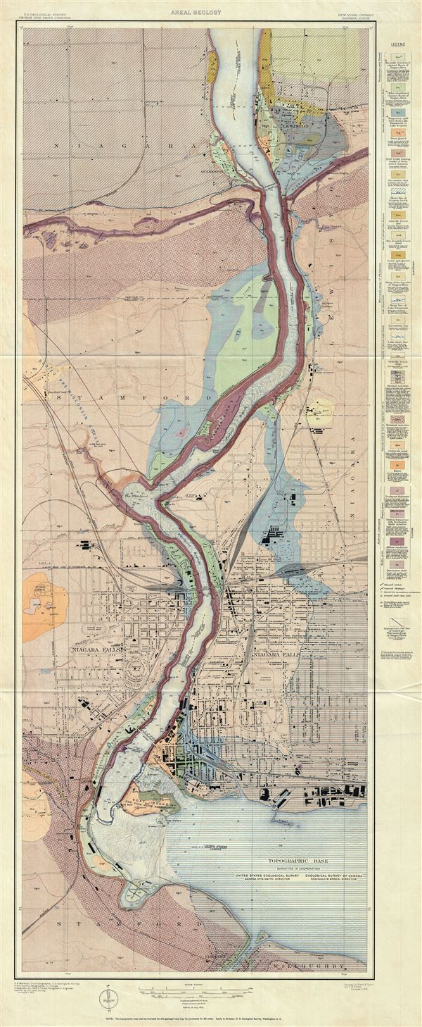
New York - Ontario. Niagara Gorge. Areal Geology.
1913 (dated) 49 x 20.5 in (124.46 x 52.07 cm) 1 : 12000
1913 (dated) 49 x 20.5 in (124.46 x 52.07 cm) 1 : 12000
Description
This is a fascinating 1913 U.S. Geological Survey map of the Niagara River, New York. The map shows the distribution of the different types of rocks and geological formations along the river and its vicinity. It covers from Lewiston in New York, southward following the Niagara River to Chippawa in Ontario, Canada. Throughout the map is beautifully detailed and color coded, with a legend along the right margin. Individual streets, buildings, bridges, railways, islands and other features are noted. The map also identifies the Horseshoe Falls in Canada and the American Falls on the American side of the river. The landings of the famous 'Maid of the Mist' boat tours are also noted.
This map is based on the geology survey conducted by Frank B. Taylor and E.M. Kindle. Topography is by Chas E. Cooke, topographic engineer, with Frank Sutton as geographer in charge and R. B. Marshall as chief geographer, U.S. Geological Survey. Issued in 1913 by the U.S. Geological Survey with George Otis Smith, Director, as part of Geological Atlas of the United States, Niagara Folio, New York, by E.M. Kindle and Frank. B. Taylor.
This map is based on the geology survey conducted by Frank B. Taylor and E.M. Kindle. Topography is by Chas E. Cooke, topographic engineer, with Frank Sutton as geographer in charge and R. B. Marshall as chief geographer, U.S. Geological Survey. Issued in 1913 by the U.S. Geological Survey with George Otis Smith, Director, as part of Geological Atlas of the United States, Niagara Folio, New York, by E.M. Kindle and Frank. B. Taylor.
Cartographer
The Office of the Coast Survey (later the U.S. Geodetic Survey) (1807 - present), founded in 1807 by President Thomas Jefferson and Secretary of Commerce Albert Gallatin, is the oldest scientific organization in the U.S. Federal Government. Jefferson created the "Survey of the Coast," as it was then called, in response to a need for accurate navigational charts of the new nation's coasts and harbors. The first superintendent of the Coast Survey was Swiss immigrant and West Point mathematics professor Ferdinand Hassler. Under the direction of Hassler, from 1816 to 1843, the ideological and scientific foundations for the Coast Survey were established. Hassler, and the Coast Survey under him developed a reputation for uncompromising dedication to the principles of accuracy and excellence. Hassler lead the Coast Survey until his death in 1843, at which time Alexander Dallas Bache, a great-grandson of Benjamin Franklin, took the helm. Under the leadership A. D. Bache, the Coast Survey did most of its most important work. During his Superintendence, from 1843 to 1865, Bache was steadfast advocate of American science and navigation and in fact founded the American Academy of Sciences. Bache was succeeded by Benjamin Pierce who ran the Survey from 1867 to 1874. Pierce was in turn succeeded by Carlile Pollock Patterson who was Superintendent from 1874 to 1881. In 1878, under Patterson's superintendence, the U.S. Coast Survey was reorganized as the U.S. Coast and Geodetic Survey (C & GS or USGS) to accommodate topographic as well as nautical surveys. Today the Coast Survey is part of the National Oceanic and Atmospheric Administration or NOAA. More by this mapmaker...
Source
U.S. Geological Survey, Geological Atlas of the United States, Niagara Folio, New York, by E.M. Kindle and Frank. B. Taylor, Washington D.C., 1913.
Condition
Very good. Minor wear along original fold lines. Blank on verso.