This item has been sold, but you can get on the Waitlist to be notified if another example becomes available, or purchase a digital scan.
1899 Julius Bien View of the Proposed Nicaragua Canal Route
NicaraguaCanal-bien-1899$600.00


Title
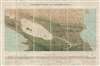
Panoramic View of the Nicaragua Canal.
1899 (undated) 23 x 35 in (58.42 x 88.9 cm) 1 : 500000
1899 (undated) 23 x 35 in (58.42 x 88.9 cm) 1 : 500000
Description
A fascinating c. 1899 Julius Bien chromolithograph view of the proposed Nicaragua Canal. The development of an intercontinental canal connecting the Caribbean (and therefore the Atlantic) with the Pacific in Central America was one of the major engineering goals of the late 19th and early 20th centuries. While the French were focusing on the Panama Canal, Americans were looking to Nicaragua. As early as 1899, United States Navy Bureau of Navigation Captain A. S. Crownshield visited the region and published a defense of the Nicaragua Route as the only reasonable route for an intercontinental canal. It was perhaps general interest spurred by Crownshild's article that inspired Bien to create this view.
Historical Context
Beginning on the Caribbean Sea not far from the modern-day Nicaragua / Costa Rica border, the route would proceed inland through a series of locks and an excavated channel to the San Juan River, from which it would proceed to Lake Nicaragua (Cocibolca) near San Carlos. Lake Nicaragua is a massive inland lake covering nearly half of the width of the isthmus. From Lake Nicaragua, another excavated channel and more locks would lower ships some 45 feet to San Juan del Sur and the Pacific. The presentation of the map makes the route seem exceptionally practical and vastly easier to construct than competing efforts further south in Panama.Volcanic Intervention
Nonetheless, a number of factors worked against the Nicaragua Route. The Panama Canal was already under construction and, despite its own problems, attracted a great deal of investment. Moreover, lobbyists in the United States warned of Nicaragua's earthquake prone landscape, heavy rainfall, and political instability. Just as investors seemed to be lining up, in spring of 1902, the volcano Momotombo, conveniently located just beyond the scope of this view, erupted, leading investors to turn their attentions to the more geologically stable Panama. Nonetheless, efforts continue to this day to complete a Nicaragua Canal and construction is currently underway by the Hong Kong Nicaragua Canal Development Investment Company (HKND Group).Visuals in the Map
Cartographically, Bien's view extends from Lago Xolotlán to the modern-day Nicaragua / Costa Rica border, and from the Pacific Ocean to the Caribbean Sea. It includes all of Lake Nicaragua, as well as Lago Xolotlán and the capital of Managua. Cities are shown, but few are named save along the bottom of the amp. Also along the bottom of the map there is an elevation profile of the canal, along with additional statistics, intended to illustrate the practicality of the route.Publication History and Census
This view was printed by Julius Bien of New York. The map bears a pastedown stamp for Edward Stanford LTD, Charing Cross, London and was likely sold at Stanford's shop. We note five examples cataloged in OCLC which are part of the institutional collections at the American Museum of Natural History in New York City, Princeton University, Harvard University, the Library of Congress, and the University of Illinois at Urbana Champaign.Cartographer
Julius (Julien) Bien (September 27, 1826 - December 21, 1909) was a German-Jewish lithographer and engraver based in New York City. Bien was born in Naumburg, Germany. He was educated at the Academy of Fine Arts, Cassell and at Städel's Institute, Frankfurt-am-Main. Following the suppression of the anti-autocratic German Revolutions of 1848, Bien, who participated in the pan-German movement, found himself out of favor in his home country and joined the mass German immigration to the United States. Bien can be found in New York as early as 1849. He established the New York Lithographing, Engraving & Printing Company in New York that focused on the emergent chromo-lithograph process - a method of printing color using lithographic plates. His work drew the attention of the U.S. Government Printing Office which contracted him to produce countless government maps and surveys, including the Pacific Railroad Surveys, the census, numerous coast surveys, and various maps relating to the American Civil War. Bien also issued several atlases both privately and in conjunction with a relation, Joseph Bien. At the height of his career Bien was elected president of the American Lithographers Association. After his death in 1909, Bien's firm was taken over by his son who promptly ran it into insolvency. The firm was sold to Sheldon Franklin, who, as part of the deal, retained the right to publish under the Julius Bien imprint. In addition to his work as a printer, Bien was active in the New York German Jewish community. He was director of the New York Hebrew Technical Institute, the New York Hebrew Orphan Asylum, and president of the B'nai B'rith Order. More by this mapmaker...
Condition
Very good. Dissected and mounted on linen.
References
OCLC 15864159. Library of Congress, G4852.N55 187- .P3.