This item has been sold, but you can get on the Waitlist to be notified if another example becomes available, or purchase a digital scan.
1666 Goos Map of Virginia, New York, New England: w/ Chesapeake Bay, Cape Cod
NieuNederlandtVirginies-goos-1666$3,750.00

Title
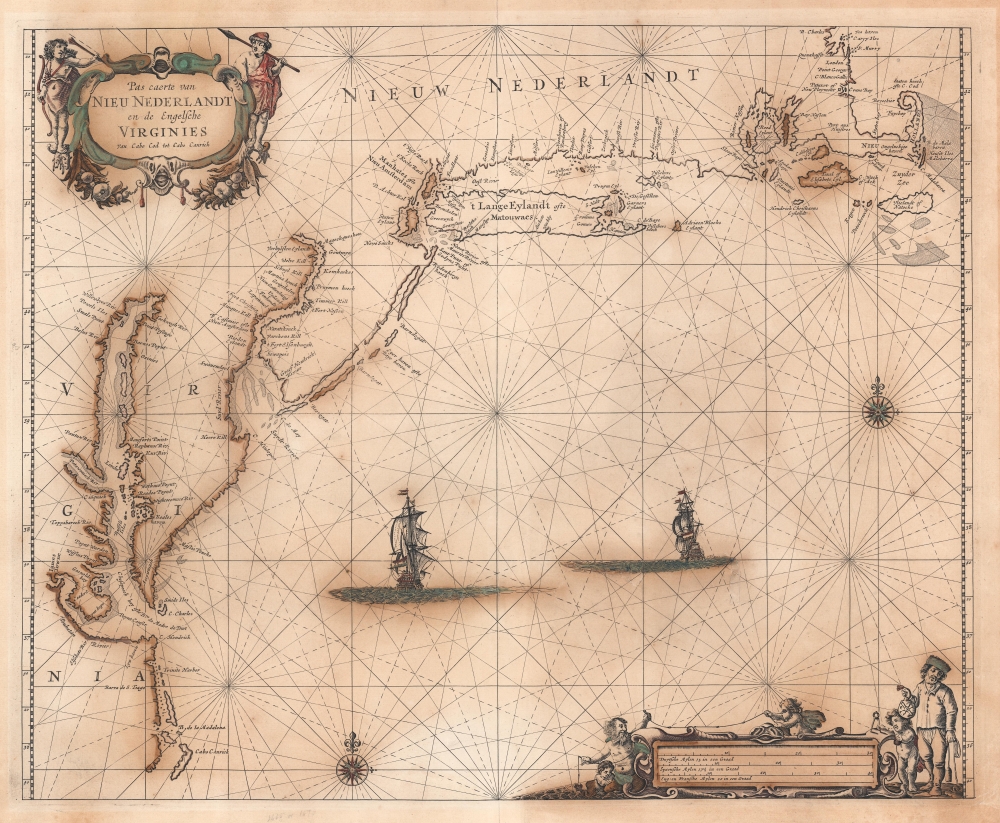
Pas Caerte van Nieu Nederlandt en de Engelsche Virginies van Capo Cod to Cabo Canrick.
1666 (undated) 16.75 x 20.5 in (42.545 x 52.07 cm) 1 : 1800000
1666 (undated) 16.75 x 20.5 in (42.545 x 52.07 cm) 1 : 1800000
Description
A striking original color 1666 Pieter Goos nautical chart or maritime map of New England, New York, New Jersey, and Virginia. Coverage follows the coast of North America from Boston Harbor to Cape Hatteras, thus embracing one of the more active mid-17th century maritime corridors in North America. At the center of the map, two Dutch ships ply the seas. Finely engraved decorative cartouche work in the upper left and lower right emphasizes the region's rich fur trade and abundant fisheries.
The Cartography
Much of the cartography is derived from the 1661 Joannes van Loon chart of the same region, but with numerous minor updates and revisions. It is one of the earliest acquirable charts to show a recognizable Cape Cod, and it includes Nantucket, Martha's Vineyard, and Long Island. Both 'Adriaen Blocks Island (Block Island) and Garners Eylant (Gardiner's Island) are illustrated and named. Although Boston Bay and the River Charles are present, Boston itself is not named on the map - although Plymouth just to the south is. New York City, by 1666 firmly in English hands and reincorporated in 1665 as 'New York', here retains the Dutch nomenclature, 'Niew Amsterdam', reflecting Dutch opinions on the matter. Along the Connecticut coast, a host of new English settlements are noted, including Gilfort, Stamfort, Stratfort, Milfort, etc. On the Delaware River, both the Dutch Fort Casimier and the Swedish Fort Christina are noted. Philadelphia, not founded until 1682, is not present. The Chesapeake Bay is prominent with considerable efforts to define major river connections, particularly the Potomac (Patawonieck) and James Rivers. Jamestown is noted.Publication History and Census
This map was engraved in Amsterdam and published in 1666 by Pieter Goos. Cartographically it reflects the 1661 map of Joannes van Loon. Being one of the better nautical charts of the region, it had a long life, appearing in atlases until about 1692. The present example appeared in Goos' De Zee-Atlas oste Water-Weerld. Nonetheless, there is only one state, with no major or minor updates during its long print run. Moreover, despite a long run on the market, the map is today quite rare. We note some 6 examples of the original 1666 map in the OCLC, although the atlas is well represented, particularly in European collections.Cartographer
Pieter Goos (1616 - 1675) was a Dutch cartographer, engraver, publisher and bookseller. Goos was born in Amsterdam, the son of cartographer, globemaker, and engraver Abraham Goos (1590 - 1643). Goos followed in his father's footsteps as a mapmaker and engraver, working with Petrus Kaerius, C.J. Visscher, John Speed, Henricus Hondius, and Johannes Janssonius, among others. Goos began publishing on his own account in 1657 and, from 1666, began issuing a series of well-received nautical atlases. His De Zee-Atlas Ofte Water-Wereld is considered one of the most extraordinary maritime atlases of the Dutch Golden Age. His most famous and elusive atlas, however, was 'The Burning Fen,' Het brandende veen verlichtende de kust van Africa ende America, a collaboration with the mathematician Arent Roggeveen (1658 - 1679). When Goos died in 1675, his widow, Margareta van den Keere, sold his copper printing plates to the publisher Jacobus Robijn (c. 1649 - 1707), who reissued many of them. More by this mapmaker...
Source
Goos, P., De Zee-Atlas oste Water-Weerld, (Amsterdam) 1666.
Condition
Good. Map exhibits highly oxidized old color - which both gives the map an old world charm and makes it extremely brittle where the color is most heavy, leading to cracking in places. The whole has consequently been stabilized on archival tissue.
References
OCLC 321056948. Burden, P., The Mapping of North America, 387. Deak, Gloria Gilda, Picturing America: 1497-1899, no. 48.