This item has been sold, but you can get on the Waitlist to be notified if another example becomes available, or purchase a digital scan.
1765 Isaak Tirion Map of Baja California and Arizona
NieuwMexicoCalifornia2-tirion-1765$450.00

Title
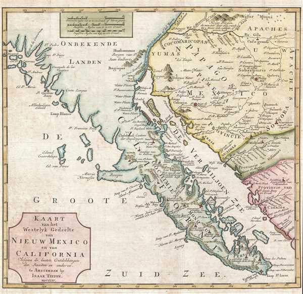
Kaart van het Westelyk Gedeelte van Nieuw Mexico en van California Volgens de Laatste Ontdekkingen der Jesuiten en Anderen.
1765 (dated) 13 x 13.75 in (33.02 x 34.925 cm) 1 : 5000000
1765 (dated) 13 x 13.75 in (33.02 x 34.925 cm) 1 : 5000000
Description
A scarce and important 1765 map detailing the Spanish/Mexican borderlands in the California-New Mexico (including modern-day Arizona) region. Despite its title, this map does not cover New Mexico, instead, it focuses on the Gulf of California, Baja California, parts of Southern California (including San Diego), and modern-day Arizona. Tirion denotes towns, indigenous villages, missions, fortifications, and some offshore detail, with mountain ranges rendered in profile.
Cartographically this map falls between the seminal mapping of Father Kino, which reattached insular California to the mainland, and the important discoveries of the Miera-Escalante Expedition. Tiron's work is a significant advancement over Kino's 1705 map, with significant new data derived from Jesuit missions and explorations throughout the region. On this map, the various Jesuit settlements are identified as little churches. These are particularly notable on the Baja Peninsula and on the Mexican mainland. Of note is the site of Casa Grande, on the River Gila. Though marked here as a mission, Casa Grande is in fact an indigenous American Indian ruin of incredible size and complexity. It was Kino who identified it as 'Casa Grande,' citing its architectural enormity. Casa Grande was not visited again until Lt. Col. Juan Bautista de Anza's expedition in 1775. Today it is protected by the National Park Service. Other sites of note include St. Diego de Pitquin, St. Philip de JHS, and, along the Colorado River, St. Dionysio, St. Pablo, St. Philip, and others. In California, the Bay of San Diego is noted, as are the badly misprojected Santa Catalina Islands.
This map was created in 1765 and issued in various formats through 1770.
Cartographer
Isaak Tirion (1705 - 1765) was a Dutch publisher in Amsterdam. Born in Utrecht, Tirion quickly rose to prominence by publishing pamphlets, historical works, and most importantly, maps and atlases. He produced several atlases and Dutch town plans. His maps are mainly based on those of Guillaume de l'Isle. Tirion eventually relocated his printing house to the prestigious Kalverstraat. In his long career, he produced eight atlases in multiple editions, some of which were published posthumously until about 1784. More by this mapmaker...
Condition
Very good. Light wear along original fold lines. Blank on verso.
References
OCLC 82678749.