This item has been sold, but you can get on the Waitlist to be notified if another example becomes available, or purchase a digital scan.
1688 Hennepin Map of North America (first map to name Louisiana)
NieuwVrankryk-hennepin-1688$1,750.00

Title
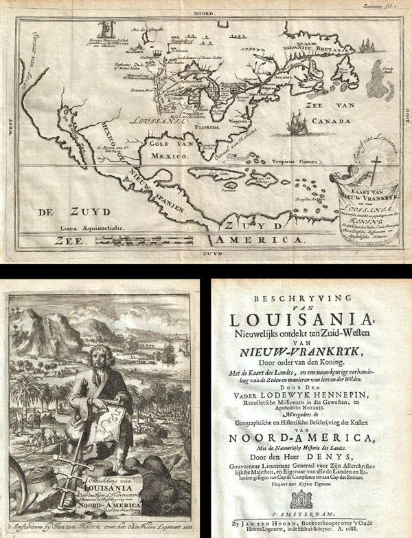
Kaart van Nieuw Vrankryk, en van Louisania Nieuwelyks Ontdekt.
1788 (dated) 7.5 x 11.5 in (19.05 x 29.21 cm)
1788 (dated) 7.5 x 11.5 in (19.05 x 29.21 cm)
Description
A work that fundamentally impacted the cartographic history of America, this is the 1688 first Dutch edition of Friar Hennepin's most important work describing his explorations through the Great Lakes and the upper Mississippi valley. This book includes the first map to name Louisiana as well as some of the earliest descriptions and depictions of the regions, including Niagara Falls. The enclosed map, entitled Kaart van Nieuw Vrankryk en van Louisiana, covers all north American from the Strait of Anian and California (which is attached to the mainland) as far east as the Grand Banks, as far north as Lake Assenipoils (Winnipeg), and as far south as Antilles and the Spanish Main. It also includes Denys' description of New France and the coasts of North America. Unlike earlier editions of this work, which only had two image plates (Niagara Falls and a Bison) this edition of Hennepin's book contains four plates depicting indigenous life and interactions with the explorers. This book is considered 'One of the most important volumes in the early history of North America' (Lande) being the first printed description of La Salle's explorations.
In 1679 the French lord René-Robert Cavelier de La Salle set out from Fort Frontenac, on Lake Ontario, to explore the Great Lakes and eventually make their way to the Mississippi River. La Salle was of the belief that the Mississippi connected to other water routes that would eventually lead to the Pacific. His scribe and chronicler on this expedition was a Dutch Friar of the Franciscan Recollect order, Antoine Louis Hennepin. Hennepin, who had a passion for 'pure and severe virtue' and La Salle, who had a passion for 'moral weaknesses' never quite saw eye to eye. Nonetheless, the expedition sailed (and were the first to do so) through Lake Ontario, Lake Erie, and Lake Huron into Lake Michigan, then followed the St. Joseph River to what is today South Bend Indiana, where they constructed Fort Crevecoeur, present day Peoria, Illinois. At this point the explorers parted ways with La Salle returning on foot to Frontenac to resupply and Hennepin continuing onward via the Illinois River to the Mississippi.
Hennepin attempted to explore southwards towards the mouth of the Mississippi but, in his own words, 'the nations did not give us the time to navigate up and down this river.' Instead he traveled northward past St. Anthony Falls and modern day Minneapolis to Lac des Issatis (Leech Lake), a source of the Mississippi. From here Hennepin attempted a return to Fort Crevecoeur, but was instead captured by a band of wandering Sioux who took him to the Mille Lacs region of Minnesota, near Lake Superior. Hennepin remained in Sioux custody until the adventurer Daneil Greysolon Delhut, who had negotiated a peace treaty with the Sioux, ransomed him.
Hennepin and La Salle never met again. La Salle went on to explore the length of the Mississippi, named Louisiana, claimed it for France, and established a short lived colony near Matagorda Bay, Texas. Hennepin, who had enough adventure, returned to France where he published an enormously popular book, Description de la Louisiane, of which this is the first Dutch edition.
This book features a map that depicts much of the upper Mississippi valley but does not suggest exploration as far as the Gulf of Mexico – as do Hennepin's two later maps. This map is believed to be the first printed map made from actual observations to bear the name 'Louisiana.' In this work Hennepin claims to have coined the term 'Louisiane' but, it was in fact La Salle who had first named the region.
This edition of Hennepin's map features a curious title cartouche in the lower right quadrant intended to represent the triumph of Christianity in Louisiana. The words 'Trumf van Louisiana' surround a cross radiating the power of god. A putto to the left of the cross supports a tapestry containing the title of the map. The armorial crest of France's House of Bourbon appears the upper left quadrant.
This book also contains a description of coastal North America by Nicolas Denys, who wrote his entire account from first person experience. Denys claimed that he is the proprietor of all lands and islands between Cap de Campseaux and Cap des Roziers (Penobscot Bay). Denys includes geographic and anthropological descriptions of the French territory, discusses native attire and customs, the lucrative bakkeljauw (codfish) fishery, and a chapter on the cold, snowy winters. One of the two plates illustrates the 'Strange history of a Sea- or Merman' in Canso harbor.
Cartographer
Antoine Louis Hennepin (May 12, 1626 - December 5, 1704) was a Catholic priest and missionary of the Franciscan Recollect order. Born in 1626 in Ath in the Spanish Netherlands, the son of a butcher. He joined the Franciscan covenant of Béthune (Pas-de-Calais) at 17, where he studied under Father Gabriel de la Ribourde. Latter he transferred to the convent of Maontargis (Loriet), where he completed his religious studies under Father Paul Huet. He entered the priesthood immediacy after. He is best known as an explorer of the interior of North America. After entering the Catholic Church he was assigned to the coast of France, where he remained until 1675. The stories he heard from sailors returning from North America intrigued him to such degree that he himself made the journey across the Atlantic. Hennepin arrived in New France as a Recollect Missionary and was selected as the scribe and chronicler for Robert Cavelier La Salle's 1678 expedition from Fort Frontenac to the Great Lakes. Hennepin, who had a passion for 'pure and severe virtue' and La Salle, who had a passion for 'moral weaknesses' never quite saw eye to eye. Nonetheless, in 1680 La Salle sent Hennepin, along with two woodsmen, to search out the source of the Mississippi. Hennepin travelled down the Illinois River as far as the Mississippi, where he passed present-day Minneapolis. Among the many firsts on this journey was the discovery and naming of St. Anthony Falls, the only cataract on the Mississippi. Hennepin then traveled northwards to Lac des Issatis, or Leach Lake, which he asserted was the source of the Father of Rivers, a term he also claims (falsely) to have coined. Though Leach Lake is a source of the Mississippi it is not generally considered to be the source. On his return journey Hennepin was taken prisoner by a wandering band of Sioux Indians who took him into the Mille Lacs region of Minnesota. Hennepin remained in Sioux custody until September of 1680 when the adventurer Daneil Greysolon Delhut, who had negotiated a peace treaty with the Sioux, ransomed him. In 1681, Hennepin began writing his first book, Description de la Louisiane, which he dedicated to Louis XIV of France, and which described the achievements of the La Salle Expedition. Hennepin's book proved to be an enormous success that significantly impact on the cartographic history of America. It is also contains the first European image of Niagara Falls. Ten years later La Salle was assassinated in modern day Texas by Pierre Duhaut. Meanwhile, Hennepin, perhaps seeing an opportunity for self-aggrandizement, fled to England where he published another book, Nouvelle Decouverte d'un tres grand Pays Situe dans L'Amerique, dedicated to William III of England. This book reaffirmed, with some controversy, Hennepin's own contribution to the discovery of North America. The false claims in Decouverte include, among other absurdities, spurious assertion that Hennepin explored the entire length of the Mississippi River. Like the first, Hennepin's second book also proved enormously popular and was influential in the mis-mapping of the Mississippi far westward of its actual location for the next 50 years. Decouverte also earned Hennepin the enmity of the French Crown and Louis XIV ordered that he be arrested if he ever attempted to return to New France. He later published a third, less important work that reasserted some of the content of the first two. Louis Hennepin died in Rome in 1705. More by this mapmaker...
Source
Hennepin, Louis, Beschryving van Louisania, nieuwelijks ontdekt ten Zuid-Westen van Nieuw-Vrankrik, door order van den Koning : met de kaart des landts, en een nauwkeurige verhandeling van de zeden en manieren van leeven der wilden door den Vader Lodewyk Hennepin..., 1688 (Jan Ten Hoorn, Dutch Edition).
Condition
Very good. Book is complete with new leather binding. The map, all engravings, and the text of this book are in very good condition.
References
Henkels, S. V. , The Bibliographer's Manual of America History: F-L. nos. 1601-3103, #2247. Sabin, J., Biblioteca Americana. A Dictionary of Books Relating to America, from its Discovery to the Present Time, #31357. Delanglez, J., Hennepin's Description of Louisiana: A Critical Essay.