This item has been sold, but you can get on the Waitlist to be notified if another example becomes available, or purchase a digital scan.
1702 Van Keulen Map of New York City, Long Island, Hudson River (New Amsterdam)
NiewNederlandNiewYork-vankeulen-1702$3,500.00

Title
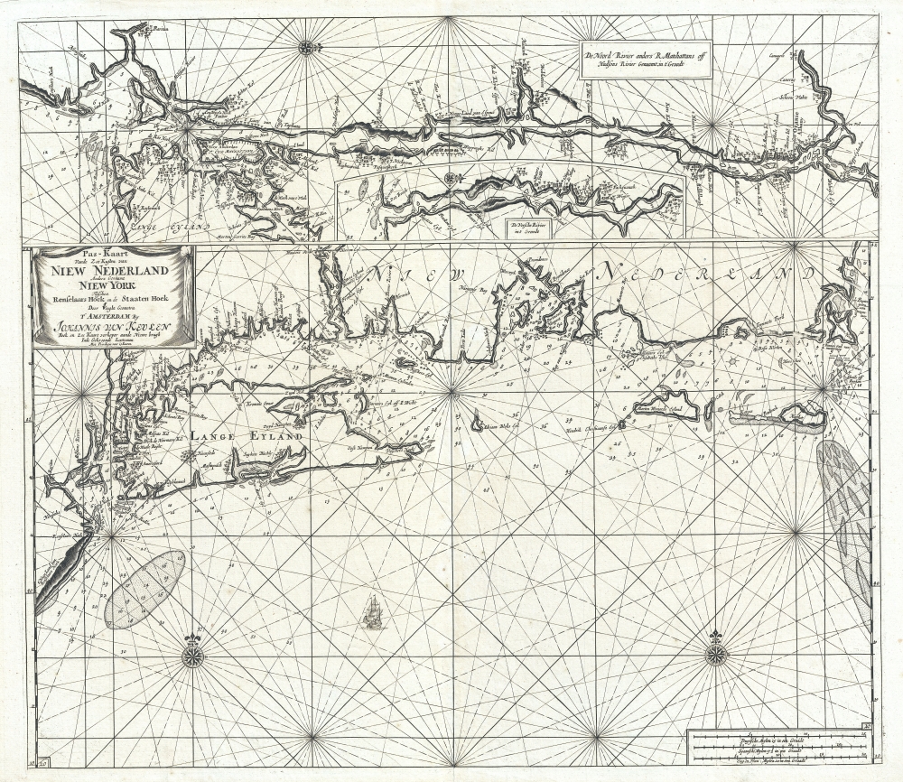
Pas-kaart vande zee kusten van Niew Nederland anders genaamt Niew York tusschen Renselaars Hock en de Staaten Hoek.
1702 (undated) 20 x 22.75 in (50.8 x 57.785 cm) 1 : 950000
1702 (undated) 20 x 22.75 in (50.8 x 57.785 cm) 1 : 950000
Description
This is Johannes van Keulen and Claes Janszoon Vooght's 1702 map of New York, Long Island, the Hudson River, and the Connecticut River. First appearing in 1684, this is the second earliest published map to detail the coast between Long Island and Cape Cod. It also features the earliest published maps of any American River. Furthermore, many of the place names throughout make their first appearance here. As such, it may be considered the high point of Dutch knowledge about New Amsterdam before the British takeover.
A Closer Look
This is essentially three maps on a single sheet. The main map, occupying the lower two-thirds of the document, illustrates the coast of New Netherland from, roughly, Sandy Hook and Staten Island eastward, along the Long Island Sound and Connecticut coast, to Martha's Vineyard and Nantucket. This is, as noted, the second earliest specific map of this region, being superseded only by Arent Roggeveen's Pascaerte van Nieu Nederland. While some aspects of the map are clearly drawn from Roggeveen, such as the dramatically foreshortened form of Long Island, other aspects, such as the sophisticated toponymy exhibited throughout reference unknown sources. As one of Amsterdam's premier cartographers, van Keulen doubtless had access to manuscript maps controlled by the Geoctroyeerde Westindische Compagnie (Dutch West Indian Company / GWIC), and we can assume that much of the new toponymy is drawn from such sources. Among the place names identified on Long Island are Breukelen (Brooklyn), Heemstede (Hempstead), Amersfoord, Oyster Bay, Zuyd Hampton (Southampton), and Oost Hampton (East Hampton); and along the Connecticut coast are Grenwits (Greenwich), Stamford, Strafford, Milford, and Gilford, among other towns. Many of these do not appear on the Roggeveen or any other earlier chart.Early Maps of American Rivers: The Hudson
Despite its important and highly influential mapping of New York and Long Island, this map's true claim to fame are the upper insets which represent the earliest specific maps of an American River (in this case 2 rivers). The main inset, which covers the entire upper quarter of the map details the course of the Hudson River from, roughly, New York Harbor to Albany. This inset is oriented to the west and offers a larger scale presentation of Manhattan and western Long Island. Here, unlike on the larger map below, New Amsterdam is specifically named. It is noteworthy that, although New York appears in the map's title, the term has not found its way onto the map itself. Perhaps van Keulen had hopes the Dutch would reclaim their colony? A number of settlements along the Hudson, including Albany, are identified.American Rivers: The Connecticut River
Within the larger inset of the Hudson River, a smaller map illustrates the course of the Connecticut River (Versche or Fresh River). Unlike the Hudson River, which was well known to the Dutch, the Connecticut River, despite being initially explored by Adriaen Block in 1614, was almost entirely dominated by English settlers and trappers. Nonetheless, Van Keulen successfully maps four known settlements, Veldt (Weathersfield), Hereford (Hartford), Zee Brock (Sea Brook), and Winser.Publication History and Census
There are four known states of this map, the present example represents state 4, issued in 1702. It is identifiable as such by the addition of drapery around the title cartouche and the number '20' in the lower left corner. All states are cartographically identical and extremely scarce on the market.CartographerS
Johannes Van Keulen (1654 – 1715) was a Dutch cartographer active in Amsterdam during the late 17th century. Van Keulen was the son of Lucas van Keulen. Van Keulen's firm, ‘In de Gekroonde Lootsman' (In the Crowned Pilot), was founded in 1678 and registered with the Amsterdam bookseller's guild as 'Cross staff-maker and bookseller.' (The cross-staff is a nautical instrument used to determine latitude.) Two years later, in 1680, they obtained a patent from the States General of Holland and West Friesland to publish nautical charts and atlases. Together with his partner, the cartographer Claes Janz Vooght, Van Keulen published numerous atlases and nautical charts, including the Zee Atlas and Nieuwe Lichtende Zee-Fakkel. It was a massive five-volume atlas containing more than 130 nautical charts. The Zee-Fakkel established the Van Keulen firm as the pre-eminent maker of Dutch sea charts in the late 17th and early 18th century. In 1714, one year before Johannes Van Keulen's death, his son, Gerard van Keulen (1678 - 1726), took charge. Gerard continued to update and republish the Zee-Fakkel until his own death in 1726. The firm was later passed on to Gerard's son, Johannes II Van Keulen (1704 - 1755), who significantly updated the atlas, especially with regard to Asia, issuing the 1753 4th Volume, known as the 'Secret Atlas'. The final editions of the atlas were published by Gerard Hulst van Keulen (1733 - 1801), Joannes II's son. The final true Van Keulen edition of the Zee-Fakkel was published posthumously in 1803. It is noteworthy that though ostensibly controlled by the Van Keulen men, it was the Van Keulen widows who maintained and managed the firm in the periods following their husbands' deaths. After the death of Gerard Hulst Van Keulen's son, Johannes Hulst Van Keulen, ownership of the family plates and business fell into the hands of the Swart family, who continued to publish until the company closed its doors 1885, ending a cartographic legacy spanning nearly 207 years. More by this mapmaker...
Claes Jansz Vooght (1638 – 1696) was a Dutch astronomer, mathematician, teacher, surveyor and cartographer active in Amsterdam during the 17th century. Vooght described himself as a 'surveyor and teacher of mathematics and the art of navigation' and published extensively on these subjects. His is known to have been a surveyor for the Council of Holland and co-authored several books with Rembrantsz Dirck van Nierop. Though little is known of Vooght's life, his most important cartographic work appeared in conjunction with the prominent Johannes Van Keulen firm, with whom he partnered in 1680. Vooght was responsible for creating and compiling most of the maps in Van Keulen's seminal Nieuwe Lichtende Zee-Fakkel, with many early editions bearing only his name. Learn More...
Source
Van Keulen, J., De Nieuwe Groote Lichtende Zee-Fakkel, Part IV, (Amsterdam: Van Keulen) 1702.
Nieuwe Lichtende Zee-Fakkel was the premier Dutch nautical atlas of the late 17th and 18th century. First introduced in 1681, over the course of its more than 100 years in production, the Zee-Fakkel expanded to six volumes. The first five volumes were published in Amsterdam by Johannes van Keulen (1654 - 1715). His son, Gerard van Keulen (1678 - 1726), reissued it in several editions with minor updates.
Grandson, Johannes II van Keulen (1704 - 1755) expanded the atlas in 1753 with Volume VI, illustrating Asian waters. This was a revolutionary addition. For three generations the Van Keulen's were the official cartographers of the VOC (Vereenigde Oostindische Compagnie / United Dutch East India Company). Until 1753, to protect their long-standing trade monopoly, the VOC jealously guarded their hydrographic data on East Asian waters, refusing the allow charts to be printed and requiring oaths of secrecy from the Van Keulens (and Bleaus before them). This led to dangerously inaccurate often contradictory charts. Thus, in 1744 Jan Harmenszoon de Marre (1696 - 1763), the VOC's Amsterdam Examiner, was instructed to work with van Keulen to publish compile, compare, and resolve the VOC's hoard of jealously guarded manuscript charts of East Asian waters. Johannes II and de Marre published the sixth volume of the Zee-Fakkel, focusing on Asian waters - if only for internal VOC use.
This was likely an attempt to consolidate and improve the general hydrography. Previously, VOC charts in manuscript were disseminated to ship captains on an as-needed basis, to be returned upon a voyage's completion. They were rarely compared or amended. A study of several VOC manuscript charts issued between 1720 and 1760 reveal striking disparities, likely resulting either from the charts being updated or copied from earlier less accurate charts. Such led to avoidable navigational and thus trade risks. A printed nautical atlas, whose hydrography was built upon the most recent and up-to-date charts, reassessed by the greatest chartmaker of the age, was a natural solution.
The new atlas, ostensibly an extension (Volume VI) of the existing commercially issued Nieuwe Lichtende Zee-Fakkel, was intended only for VOC use, and so became known as the 'Secret Atlas'. The printing run was extremely small, and access tightly controlled. VOC ship captains navigating to the Far East were given a copy on departure and expected to return it in good condition on return. Even so, the maps of the 'Secret Atlas' were disseminated, perhaps by the van Keulen's themselves. We note evidence of 'secret' Dutch hydrography in charts of the English Pilot as well as in other Dutch charts. Nonetheless, original maps from 'Secret' Zee-Fakkel volume VI remain of the utmost rarity.The firm passed to great-grandson Gerard Hulst van Keulen (1733 - 1801) under whose imprint the final 1803 van Keulen edition was published posthumously.
Grandson, Johannes II van Keulen (1704 - 1755) expanded the atlas in 1753 with Volume VI, illustrating Asian waters. This was a revolutionary addition. For three generations the Van Keulen's were the official cartographers of the VOC (Vereenigde Oostindische Compagnie / United Dutch East India Company). Until 1753, to protect their long-standing trade monopoly, the VOC jealously guarded their hydrographic data on East Asian waters, refusing the allow charts to be printed and requiring oaths of secrecy from the Van Keulens (and Bleaus before them). This led to dangerously inaccurate often contradictory charts. Thus, in 1744 Jan Harmenszoon de Marre (1696 - 1763), the VOC's Amsterdam Examiner, was instructed to work with van Keulen to publish compile, compare, and resolve the VOC's hoard of jealously guarded manuscript charts of East Asian waters. Johannes II and de Marre published the sixth volume of the Zee-Fakkel, focusing on Asian waters - if only for internal VOC use.
This was likely an attempt to consolidate and improve the general hydrography. Previously, VOC charts in manuscript were disseminated to ship captains on an as-needed basis, to be returned upon a voyage's completion. They were rarely compared or amended. A study of several VOC manuscript charts issued between 1720 and 1760 reveal striking disparities, likely resulting either from the charts being updated or copied from earlier less accurate charts. Such led to avoidable navigational and thus trade risks. A printed nautical atlas, whose hydrography was built upon the most recent and up-to-date charts, reassessed by the greatest chartmaker of the age, was a natural solution.
The new atlas, ostensibly an extension (Volume VI) of the existing commercially issued Nieuwe Lichtende Zee-Fakkel, was intended only for VOC use, and so became known as the 'Secret Atlas'. The printing run was extremely small, and access tightly controlled. VOC ship captains navigating to the Far East were given a copy on departure and expected to return it in good condition on return. Even so, the maps of the 'Secret Atlas' were disseminated, perhaps by the van Keulen's themselves. We note evidence of 'secret' Dutch hydrography in charts of the English Pilot as well as in other Dutch charts. Nonetheless, original maps from 'Secret' Zee-Fakkel volume VI remain of the utmost rarity.
Condition
Very good condition. Strong impression. Original centerfold. Blank on verso. There is a slight scuff at the at the center of the map along the Hudson River.
References
Burden, P., The Mapping of America: A List of Printed Maps, 1151-1670, 587, State 4. McCorkle, B. B, New England in Early Printed Maps 1513 - 1800, 684.3. Stokes, I. N. P., The Iconography of Manhattan Island, 1498-1909, vol. II pp. 158-159 (ill. plate 57). OCLC 48861403, 166645448, 881445491.