This item has been sold, but you can get on the Waitlist to be notified if another example becomes available, or purchase a digital scan.
1942 Owens and Minneapolis Morning Tribune Map of Tunisia
NorthAfricanArea-owens-1942$150.00

Title
North African Area Where Allies Battle Axis Forces.
1942 (dated) 22 x 15.75 in (55.88 x 40.005 cm) 1 : 1404000
1942 (dated) 22 x 15.75 in (55.88 x 40.005 cm) 1 : 1404000
Description
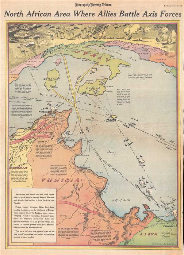
This is a Tuesday, December 22, 1942 Charles Hamilton Owens and Minneapolis Morning Tribune pictorial map of Tunisia and the Mediterranean Sea. The map depicts the region from southern Europe, including France, Italy, and the Balkans to Tunisia, Algeria, and Libya.
World War II in North Africa
At the time of its publication, Operation Torch (the Allied invasion of Morocco and Algeria) had happed six weeks before and the American, British, and French forces that participated in the landings had since marched across Morocco and Algeria to Tunisia. General Sir Bernard Law Montgomery and his 8th Army had been fighting Axis forces in a back-and-forth campaign in the western portion of North Africa since 1940. Now, the 8th Army was approaching Tunisia from the east, squeezing Axis forces between the two armies. Unfortunately for the Allies, delays in the drive across Algeria allowed the Axis forces in Tunisia time to move in reinforcements that more than tripled their overall strength. The cities of Tunis and Bizerte in northern Tunisia had been fortified and the Allies faced an unknown foe in the form of five brand new Pz. VI (Tiger) tanks, which had not yet been combat tested. Per the Encyclopedia Britannica, 'The Allies had lost the race to Tunis, but that tactical failure would yield an enormous strategic victory; Hitler and Mussolini were thus induced to pour significant resources into Tunisia at a time when those assets were desperately needed elsewhere.' The fighting in North Africa would resume two days later, on December 24th and would drag on for another five months, as Axis forces would not surrender until May 13, 1943.
A Closer Look at the Map
One of the most striking features of this map is how apparent Owens renders the vital Mediterranean transportation and supply lines. Critical to both Axis and Allied armies, the close proximity of Sicily, Sardinia, and peninsular Italy gives the viewer the opportunity to visually understand the ease with which Axis forces could be sent to Tunisia. The Allied advance from Algeria is illustrated by large red arrows, while Axis reinforcements from Italy are show by one large yellow arrow. The road network along the coast of Libya and Tunisia is illustrated, and coastal cities from Tripoli to Sfax, Sousse, Tunis, Bizerte, and Bone are all illustrated and labeled. An incredible vignette of Axis forces being airlifted into the combat zone occupies the top portion of the map, complete with tanks being flown in attached to the bellies of Nazi aircraft and paratroopers jumping into the fight.
This map was drawn by Charles Hamilton Owens and published by the Minneapolis Morning Tribue onDecember 22, 1942.
CartographerS
Charles Hamilton Owens (Feb 16, 1881 - March 3, 1958) was an American painter and illustrator and staff illustrator for the Los Angeles Times. Born in San Francisco, he had a passion for drawing from a young age. After landing a job as a messenger for The San Francisco Examiner, Owens began being taught his trade by the newspaper's illustrators. Although it is unclear exactly where Owens started his career as a newspaper staff artist, his reputation was launched by his detailed sketches of the 1906 San Francisco earthquake and fire for a New York paper, using only wire reports and his knowledge of the city. By 1910, Owens was working for the Los Angeles Examiner. Even at this point in his career, Owens was known for experimenting with new forms of illustration, fusing drawings of events with photographs. Owens's map of the Titanic disaster used a high oblique perspective, 'capturing the earth's sphericity and showing the polar regions on a curving horizon.' By the 1920s, Owens reputation as an artist in Los Angeles had grown beyond the realm of journalism. He had a studio and received commissions for landscapes and had exhibited watercolors of California and Hawaii landscapes. Thus, when Owens began creating his war series in April/May 1942, he had all the necessary skills to create visually striking works. The Los Angeles Times began a series of maps for its readers, which were full-page inserts that would appear every Monday and Saturday. Owens's maps would be included in the Monday issues, and a Rand McNally map would be included on Saturdays. The Rand McNally maps, however, were discontinued on June 27, 1942, but Owens's maps continued to be printed. His last war map was published on September 10, 1945, a little over a week after the Japanese surrender. Owens died in Los Angeles on March 3, 1958. More by this mapmaker...
The Minneapolis Tribune (1867 - present) was founded by Colonel William S. King, William D. Washburn, and Dorilus Morrison and the first issue was published on May 25, 1867. In 1941, the Cowles family of Des Moines, Iowa bought the Tribune and merged it with their other holdings in Minneapolis, giving the Cowles family ownership of all the city's major newspapers. The Tribune became the city's morning newspaper, and the Star-Journal was the evening newspaper. The two published a joint Sunday edition. The newspaper is still published today, under the name Star Tribune. Learn More...
Condition
Good. Newsprint. Verso repair to bottom right corner. Closed margin tears professionally repaired on verso. Text on verso.