This item has been sold, but you can get on the Waitlist to be notified if another example becomes available, or purchase a digital scan.
1740 Albrizzi Map of North America
NorthAmerica-albrizzi-1740$650.00

Title
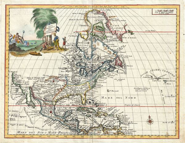
Carta Geografica Dell' America Settentrionale.
1740 (undated) 13.5 x 17.5 in (34.29 x 44.45 cm) 1 : 26000000
1740 (undated) 13.5 x 17.5 in (34.29 x 44.45 cm) 1 : 26000000
Description
An attractive 1740 map of North American by Giambattista Albrizzi. Based upon an earlier map by Guillaume Delisle, this map covers all of North America from Baffin Bay to Panama and the Spanish Main and from the Atlantic to the Pacific. The western coast of North America is mapped as far north as Cape Mendocino, beyond which no explores had yet ventured.
The presentation of California is of exceptional interest. Despite the discoveries of Eusebio Kino the early 18th century in favor of Baja's peninsularity, many mid-18th century mapmakers still debated the fact. Here Albrizzi commits to neither idea, instead leaving the northern extremis of the Gulf of California open and unexplored. He does however, including a secondary gulf further north on the Pacific side of the Baja peninsula which he notes, in Italian, 'has not yet been discovered.' The Sierra Nevada mountains are noted just north of Nova Albion, the lands claimed by Francis Drake for the British crown in 1759.
Although an Italian map the political geography leans heavily in favor of the French, possibly due to Albrizzi's borrowing of the map from Delisle. The British colonies are restricted to a narrow strip of land between Charlestown and Maine and limited on the west by the Appalachian Mountains. Spain naturally controls New Mexico, Mexico, and California. The remainder is dominated by France, including much of modern day Texas, Florida, Carolina, Georgia, all of the Great Lakes, the Upper Mississippi Valley, and most of modern day Canada. France's claims to Florida, Carolina, and Georgia date to colonial efforts in the 16th century, but as in the present case, persist on maps until the treaties at the end of the French and Indian War.
The phantom island of Borondon appear as the eastern edge of the map just beyond the Saragasso Sea. Better known as St. Brendan's Island, Borondon appears in texts as early as the 9th century. According to the legend, St. Brenden was and Irish monk who, along with his confederates, sailed westward into the Atlantic in the hopes of evangelizing to undiscovered island peoples. Some claim that Brenden made it all the way to Newfoundland in the 6th century, on the way discovering his namesake island. Traditionally the island is located to the west of the Canaries, where it is called the 'Eighth Canary Island,' and it appears only to the Blessed, earning it another name, 'the Isle of the Blessed.'
Albrizzi's incorporation of a large decorative cartouche in the upper left quadrant is of special note. The graphic, which includes Poseiden alongside stylized American Indians, was most likely drawn by the well-known Italian artist Giovanni Battista Piazetta (c. 1682 - 1754). Piazetta's graphic elements are in this case rather innovative in that they attempt to include both allegorical (Poseidon) and descriptive elements. The transition to more descriptive cartouche work thus illustrated marks important advancement in 18th century Italian school cartographic publishing and set the stage for the later work of Antonio Zatta, among others.
This map was drawn and prepared for issued in G. Albrizzi's 1740 Atlante Novissimo che Contiene Tutte le Parti del Mondo. The work is essentially a decorative Italian reissue of Isaak Tirion's 1730 reissue of G. Delisle's c. 1700 atlas.
CartographerS
Giambattista Albrizzi (1698 - 1777), a.k.a. Giovanni Battista Albrizzi, was an Italian publisher and journalist active in Venice during the mid-18th century. Albrizzi was the scion of a well-established Venetian publishing dynasty and followed in the footsteps of his father, Girolamo Albrizzi, who founded the family printing business and is known for publishing the work the great Venetian cartography Vincenzo Coronelli. Giambattista Albrizzi is generally considered to be the most prominent 18th century Venetian publisher. Today he is best known for his friendship and collaboration with Giovanni Battista Piazzeta (1683 - 1754), a well know Venetian artist and engraver, whose drawings and engravings appear in many of Albrizzi's publications, including his maps. Giambattista Albrizzi's cartographic work, while not particularly innovative in terms of content, often featured elaborate decorative elements designed by Piazzeta. Through the integration of such decorative elements, Albrizzi hopped to revive the reputation of Venetian publishing, which since the late 17th century, had fallen in regard since the days of Girolamo. His work helped lay the foundations for Italian school decorative cartography in the late 18th and early 19th century, including the work of Antonio Zatta, among others. In addition to Albrizzi's work as a map and book publisher, he also issued a weekly journal, Novelle della Repubblica delle Lettere, a kind of early newspaper that played an important role in Venetian business and intellectual life. More by this mapmaker...
The De L'Isle family (fl. c. 1700 - c. 1760) (also written Delisle) were, in composite, a mapmaking tour de force who redefined early 18th century European cartography. Claude De L'Isle (1644 -1720), the family patriarch, was Paris based a historian and geographer under Nicholas Sanson. De L'Isle and his sons were proponents of the school of "positive geography" and were definitive figures, defining the heights of the Golden Age of French Cartography. Of his twelve sons, four, Guillaume (1675 - 1726), Simon Claude (1675 - 1726), Joseph Nicholas (1688 - 1768) and Louis (1720 - 1745), made a significant contributions to cartography. Without a doubt Guillaume was the most remarkable member of the family. It is said that Guillaume's skill as a cartographer was so prodigious that he drew his first map at just nine years of age. He was tutored by J. D. Cassini in astronomy, science, mathematics and cartography. By applying these diverse disciplines to the vast stores of information provided by 18th century navigators, Guillaume created the technique that came to be known as "scientific cartography", essentially an extension of Sanson's "positive geography". This revolutionary approach transformed the field of cartography and created a more accurate picture of the world. Among Guillaume's many firsts are the first naming of Texas, the first correct map of the Mississippi, the final rejection of the insular California fallacy, and the first identification of the correct longitudes of America. Stylistically De L'Isle also initiated important changes to the medium, eschewing the flamboyant Dutch style of the previous century in favor of a highly detailed yet still decorative approach that yielded map both beautiful and informative. Guillaume was elected to the French Academie Royale des Sciences at 27. Later, in 1718, he was also appointed "Premier Geographe du Roi", an office created especially for him. De L'Isle personally financed the publication of most of his maps, hoping to make heavy royalties on their sales. Unfortunately he met an untimely death in 1728, leaving considerable debt and an impoverished child and widow. De L'Isle's publishing firm was taken over by his assistant, Phillipe Buache who became, posthumously, his son in law. The other De L'Isle brothers, Joseph Nicholas and Louis De L'Isle, were employed in the Service of Peter the Great of Russia as astronomers and surveyors. They are responsible for cataloguing and compiling the data obtained from Russian expeditions in the Pacific and along the northwest coast of America, including the seminal explorations of Vitus Bering and Aleksei Chirikov. The De L'Isles, like their rivals the Vaugondys , must be considered speculative geographers. Speculative geography was a genre of mapmaking that evolved in Europe, particularly Paris, in the middle to late 18th century. Cartographers in this genre would fill in unknown areas on their maps with speculations based upon their vast knowledge of cartography, personal geographical theories, and often dubious primary source material gathered by explorers and navigators. This approach, which attempted to use the known to validate the unknown, naturally engendered many rivalries. The era of speculatively cartography effectively ended with the late 18th century explorations of Captain Cook, Jean Francois de Galaup de La Perouse, and George Vancouver. Learn More...
Source
Albrizzi, G. B., Atlante Novissimo che Contiene Tutte le Parti del Mondo, (Venice: Albrizzi) 1740.
Condition
Very good. Original Platemark visible. Wide clean margins. Blank on verso.
References
Library of Congress, Geography and Map Division, G3300 1750 .L4. Phillips (Atlases) 594.